Early Map of the Dutch
Colony of New Netherland
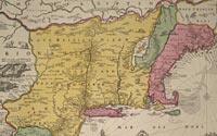
Nicolaes Visscher (1618-1679)
Novi Belgii Novaeque Angliae
nec non partis Virginae tabula
[Amsterdam, ca. 1685]
Hand-colored engraving
Geography & Map Division
(21B.7)
|
Based on the explorations of Henry Hudson, the Dutch claimed the
territory extending from the Delaware Bay to Connecticut River,
establishing the colony known as New Netherland. Nicolaes Visscher's
mid-seventeenth century map of this Dutch colony is one of the best
known maps of the region. It also boasts a vignette, in the lower
right hand corner, with one of the earliest views of New Amsterdam,
renamed New York City in 1664.
|