George Washington,
Mapmaker
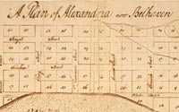
A Plan of Alexandria, now Belhaven
Manuscript Map
1749
Geography & Map Division
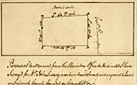
[Plat of a survey for John Lindsey
of 223 acres in Frederick Co., VA]
Manuscript Map
1750
Geography & Map Division
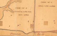
A Plan of My Farm on Little
Huntg. Creek & Potomak, R.
Manuscript Map
1766
Geography & Map Division
|
George Washington, best known as a planter, soldier,
and statesman, was trained as a surveyor during his late teenage
years and practiced surveying in the western part of Virginia
during the 1750s. Recent inventories indicate that he drew or
annotated at least 150 maps during his lifetime. Of these, more
than forty are found in various collections of the Library of
Congress. Most of these pertain to land surveys in western Virginia,
military operations in southwestern Pennsylvania, and surveys
of his lands near Mount Vernon, Virginia.
Here are examples of Washington's exemplary mapmaking
skills. The first map was drawn by Washington when he was about
seventeen years old. He prepared this manuscript plan of Alexandria,
Virginia, as well as a similar map of the town site before the
streets and lots were laid out. The town, which was formally established
on July 13, 1749, consisted of eighty-four lots, most of which
were one-half acre in size. The site for this new town focused
on a tobacco inspection warehouse and the stores of several Scottish
merchants, located on the Potomac River just north of Great Hunting
Creek in a small community that was originally known as Belhaven.
It is possible that Washington prepared this map while he was
apprenticed to the county surveyor John West, whom he assisted
in surveying the town boundaries and lots. He apparently prepared
the map to send to his half-brother Lawrence, who was in England
at the time, to show him the two town lots that had been purchased
for him.
During the early 1750's Washington was employed
as a surveyor for several counties in western Virginia. An example
of his work is this "metes and bounds" survey for a tract of land
in Frederick County, Virginia.
Washington prepared this manuscript plan of lands
he had recently purchased adjacent to his ancestral home of Mount
Vernon. This is one of the few examples of colonial-era plantation
maps in the Library's collection.
|