A Colonial Road Atlas
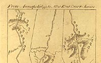
"Annapolis to New Kent Court House"
A Survey of the Roads of the United
States of America. New York: 1789.
Additional images:
Page 1 - Page
2 - Page 3 - Page
4 - Page 5 - Page
6 - Page 7 -
Page 8 - Page
9 - Page 10 - Page
11 - Page 12 - Page
13 - Page
14 - Page 15 - Page
16 - Page 17 - Page 18
Geography & Map
Division
|
Irish-born engineer and surveyor, Christopher
Colles produced what is considered the first road map or guide
book of the U.S. It uses a format familiar to modern travelers
with each plate consisting of two to three strip maps arranged
side by side, covering approximately 12 miles. Colles began this
work in 1789, but brought the project to an end in 1792 after
obtaining relatively few subscriptions. But in that time, he compiled
an atlas covering approximately 1,000 miles from Albany to Williamsburg,
and is invaluable today for understanding the developing road
network in the new nation.
|

