Postal Memory Maps
Frank H. Galbraith
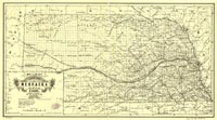
"Nebraska,
NE quadrant," Galbraith's Railway Mail Service Maps.
Chicago: McEwen Map Co., 1897
Hand-colored manuscript map
Geography & Map Division (133.12a)
[ G&M Digital ID# g4191 rr002520 ]
|
Frank H. Galbraith, a clerk with the Railway Mail Service, developed
training maps in the late 1800s to assist company clerks sorting
mail on the railroads in learning complex railway mail distribution
networks for civil service examinations required by the Post Office
Department. His hand-drawn pictorial maps were based on the premise
of associating easily recognized cultural, historical and regional
icons with post office names in order to create strong first impressions
when memorizing spatial relationships along various rail lines.
Galbraith focused on the mid-western railroad expansion, preparing
maps for eight states, including this portion of Nebraska.
|