|
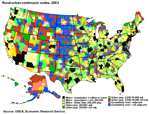
Rural-Urban Continuum Codes form a classification
scheme that distinguishes metropolitan (metro) counties by the population
size of their metro area, and nonmetropolitan (nonmetro) counties by degree
of urbanization and adjacency to a metro area or areas. The metro and
nonmetro categories have been subdivided into three metro and six nonmetro
groupings, resulting in a nine-part county codification. The codes allow
researchers working with county data to break such data into finer residential
groups beyond a simple metro-nonmetro dichotomy, particularly for the
analysis of trends in nonmetro areas that may be related to degree of
rurality and metro proximity.
All U.S. counties and county equivalents are grouped according
to their official metro-nonmetro status announced by the Office
of Management and Budget (OMB) in June 2003, when the population
and worker commuting criteria used to identify metro counties
were
applied to results of the 2000 Census. Metro counties are distinguished
by population size of the Metropolitan Statistical Area of which
they are part. Nonmetro counties are classified according to the
aggregate size of their urban population. Within the three urban
size categories, nonmetro counties are further identified by whether
or not they have some functional adjacency to a metro area or
areas.
A nonmetro county is defined as adjacent if it physically adjoins
one or more metro areas, and has at least 2 percent of its employed
labor force commuting to central metro counties. Nonmetro counties
that do not meet these criteria are classed as nonadjacent.
Find the Rural-Urban
continuum codes for the counties in your State.
In concept, the 2003 version of the Rural-Urban Continuum Codes is comparable
with that of earlier decades. However, OMB made major changes in its metro
area delineation procedures for the 2000 Census, and the Census Bureau
changed the way in which rural and urban are measured. Therefore, the
new Rural-Urban Continuum Codes are not fully comparable with those of
earlier years. OMB's changes added some additional metro areas by no longer
requiring that a metro area must have at least 100,000 population if its
urbanized area has no place of at least 50,000 people. More importantly,
simplifying the worker commuting criteria that determine outlying metro
counties had the effect of both adding numerous new outlying counties
to metro status while deleting a smaller number that were previously metro.
The Census Bureau made a radical shift in determining Rural-Urban
boundaries by changing and liberalizing the procedures for delineating
urbanized areas of 50,000 or more people, and abandoning place
boundaries in measuring urban or rural population. The procedures
used in defining
Urbanized Areas were extended down to clusters of 2,500 or more
people, based solely on population density per square mile. In
this
manner, lightly settled sections of municipalities were treated
as rural and densely settled areas adjoining urban cores were
treated
as urban, regardless of whether they were incorporated or not.
Thus
"urban clusters" need not necessarily have at least one
incorporated or unincorporated place of 2,500 population, and
not
all incorporated or unincorporated places of 2,500 population constitute
urban clusters. On balance, these completely computerized techniques
for identifying and bounding urban areas have enlarged the urban
population. It is not possible to redefine Rural-Urban Continuum
Codes for prior censuses in a manner consistent with those of 2003.
In earlier versions of the Rural-Urban
Continuum Codes, metro areas with 1 million population or more were subdivided
between central counties (Code 0) and fringe counties (Code 1). The Code
1 group has become much less meaningful in the last two censuses as more
and more counties of large metro areas have been rated as central counties
by OMB procedures. In 2000, only 1.6 percent of the population of large
metro areas was in fringe counties. Therefore, this distinction has been
dropped. Codes 0 and 1 have been combined, and the new code 1 represents
all counties in metro areas of 1 million or more population.
All told, the 2003 Rural-Urban continuum code scheme includes
1,089 metro counties and 2,052 nonmetro counties. Independent cities
of
Virginia have been combined with their counties of origin.
| 2003 Rural-Urban Continuum Codes |
| Code |
Description |
| Metro counties: |
| 1 |
Counties in metro areas of 1 million population or more |
| 2 |
Counties in metro areas of 250,000 to 1 million population |
| 3 |
Counties in metro areas of fewer than 250,000 population |
| Nonmetro counties: |
| 4 |
Urban population of 20,000 or more, adjacent to a metro area |
| 5 |
Urban population of 20,000 or more, not adjacent to a metro area |
| 6 |
Urban population of 2,500 to 19,999, adjacent to a metro area |
| 7 |
Urban population of 2,500 to 19,999, not adjacent to a metro area |
| 8 |
Completely rural or less than 2,500 urban population, adjacent to
a metro area |
| 9 |
Completely rural or less than 2,500 urban population, not adjacent
to a metro area |
| Rural-Urban Continuum Codes,
number of counties and population |
| Code |
Number of counties |
2000 population
|
| Metro counties: |
|
1 |
413
|
149,224,067
|
|
2 |
325
|
55,514,159
|
|
3 |
351
|
27,841,714
|
| Nonmetro counties: |
|
4 |
218
|
14,442,161
|
|
5 |
105
|
5,573,273
|
|
6 |
609
|
15,134,357
|
|
7 |
450
|
8,463,700
|
|
8 |
235
|
2,425,743
|
|
9 |
435
|
2,802,732
|
| |
|
U.S. total |
3,141
|
281,421,906
|
This coding scheme was originated in 1975 by David L. Brown, Fred
K. Hines, and John M. Zimmer, then of the Economic Research Service,
for a report Social and Economic Characteristics of the Population
in Metro and Nonmetro Counties: 1970. It was updated after
both the 1980 and 1990 censuses, with a somewhat more restrictive
procedure
for determining metro adjacency. The versions based on the 1970,
1980, and 1990 Censuses are all found on this ERS website:
|