Civil War Maps
Jedediah Hotchkiss (1828-1899)
Manuscript notebooks and map,
[1862-65]
Geography & Map Division
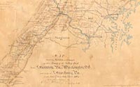
Map showing Routes and Camps of the Army
of the Valley District from Staunton, Virginia
to Washington, D.C. and back to Strasburg, Virginia
from June 27th to July 22nd, 1864
Geography & Map Division
![Manuscript notebook [1862-65]](images/s47.1a-th.jpg)
Jedediah Hotchkiss (1828-1899)
Manuscript notebook [1862-65]
Geography & Map Division
Purchase from Mrs. R.E. Christian, 1948 (47.1a)
Jedediah Hotchkiss (1828-1899)
Map of Chancellorsville, 1863]
Hand-colored manuscript
Geography & Map
Division
Purchase from Mrs. R.E. Christian, 1948 (42A.6)
[ G&M Digital ID #g3884c cwh00129 ]
|
Jedediah Hotchkiss, a topographic engineer in the Confederate States
Army, prepared maps and provided geographic intelligence for Thomas
J. "Stonewall" Jackson, Robert E. Lee, Richard Ewell, Jubal Early,
and John B. Gordon. His collection is the jewel among the more than
2,200 Civil War maps in the Library, containing 341 field notebooks,
detailed reconnaissance maps, and finely drawn after-battle maps,
some annotated by Jackson, Lee, and others, indicating their use
in planning campaigns. The Library also holds a 27,000-item manuscript
collection with diaries, correspondence, and notebooks compiled
by Hotchkiss.
Born and educated in New York State, Hotchkiss moved to Virginia's
Shenandoah Valley in 1847. At the outbreak of the Civil War, he
offered his services to the Confederate army and was assigned to
the staff of General Jackson as a topographic engineer of the Valley
District, Department of Virginia. One of his most remarkable achievements
was the preparation of a detailed topographic map of the Shenandoah
Valley, measuring 71/2 by 3 feet.
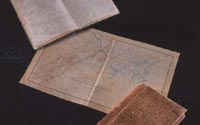
Three items representative of Hotchkiss's work are illustrated
here. The closed field notebook shows his inscription on the cover:
"This volume is my field sketch book that I used during the Civil
War. Most of the sketches were made on horseback just as they now
appear. The colored pencils used were kept in the places fixed on
the outside of the other cover. These topographical sketches were
often used in conferences with Generals Jackson, Ewell and Early."
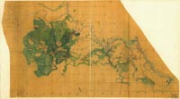
Another field notebook, recording the positions of the Second Corps
of the Army of Northern Virginia during 1864-65 engagements, is
open to a page of rough sketch notes. The finished manuscript map
covers the area from the southern Shenandoah Valley to Washington,
D.C., and was one of the maps prepared for an atlas to accompany
the final report on the Campaign of 1864. The atlas was not published,
but a number of the maps were reproduced in the Atlas to Accompany
the Official Records of the Union and Confederate Armies, 1891-95.
The collection was purchased by the Library in 1948, from Mrs.
R. E. Christian of Deerfield, Virginia, the granddaughter and last
surviving descendant of Hotchkiss.
|


![Manuscript notebook [1862-65]](images/s47.1a.jpg)
