Stephen Austin's Map
of
Texas
Stephen F. Austin (1793B1836)
Mapa
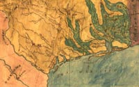
topográfico de la provincia de Texas, ca. 1822
Hand-colored manuscript map
Geography and Map Division (114.12)
[ G&M digital ID# g4030 ct000005 ]
|
Texas, the sparsely settled northeastern frontier of Mexico, was
inadequately mapped when Stephen Austin visited there in 1821-1822
to locate and confirm a colonization grant originally made to his
father. As a result of his travels, he prepared a manuscript map
showing settlements in eastern Texas, annotated to show vegetation
-- prairie land in yellow and wood land in green -- making it one
of the earliest
examples of American thematic mapping.
|