The Kansas and Nebraska
Territories
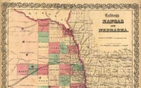
J. H. Colton (1800-1893)
Nebraska and Kansas. New York, 1855
Hand-colored and annotated lithograph map
Geography & Map Division (49.9)
[ G&M Digital ID # g4200 ct00089 ]
|
Focusing on the new territories of Kansas and Nebraska established
by Congress in 1854, this commercially published map also reflects
U.S. interest in western expansion and the construction of a transcontinental
railroad. Not only are several proposed transcontinental routes
boldly marked across the Great Plains, but two insets show the
results of the 1854 Gadsden Purchase that finalized the boundaries
of the conterminous United States. Like early maps of discovery,
empty spaces are filled pictures--not of sea monsters but indigenous
wildlife and Native Americans who populated the area.
|