Surveying Grand Canyon
William H. Holmes
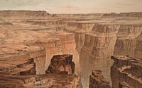
"Foot of Toroweap Looking East"
from Capt. Clarence E. Dutton.
Monograph of the Tertiary History of the Grand Cañon District.
Washington, D.C.: Government Printing Office, 1882
Offset lithograph
Geography & Map Division
(48A.1)
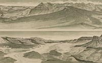
William H. Holmes
"Panoramic View of the Grand Canyon"
from Capt. Clarence E. Dutton.
Monograph of the Tertiary History
of the Grand Cañon District
Washington, D.C.: Government
Printing Office, 1882
Offset lithograph
Geography & Map Division
(48A.4)]
|
This panoramic view of the Grand Canyon by William H. Holmes was
published in Clarence E. Dutton's 1882 Atlas to Accompany
the Monograph on the Tertiary History of the Grand Cañon
District. This map was made as part of a government-sponsored
survey of the canyon, which was the first attempt at stratigraphic
mapping in the United States. Holmes was the leading scientific
illustrator of topographic and geologic phenomena for the Great
Western Surveys following the Civil War. He later became the first
director of the National Gallery of Art in Washington, D.C.
|