Surveying
the West
![Explorations in 1859 [showing Mullan Road in Eastern Columbia River Plateau]](images/at0114_10as-th.jpg)
Gustavus Sohon (1825-1903)
Explorations in 1859 [showing Mullan
Road in Eastern Columbia River Plateau]
Gift of the Sohon Family
Geography & Map Division
(114.10a)
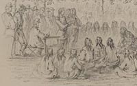
Council with Friendly Nez Perces
Indians Held by Col. G. Wright, U.S.A, August 4, 1858, near Fort
Walla Walla
Pencil on paper
Purchased from Leigh Carter
Geography & Map Division
(114.10b)
|
Gustavus Sohon, a German immigrant, was employed by the U.S. government
between 1852 and 1863 as an illustrator and cartographer of explorations
of the Rockies and Pacific Northwest. During his last five years
of federal service, he worked under Col. George Wright, who headed
a military expedition associated with the building of the Mullan
Road, a 624-mile long military wagon road constructed to connect
the Columbia and Missouri rivers. Sohon, a gifted illustrator, captures
the Nez Perce Indians in council with Col. Wright, near Fort Walla
Walla, Washington, prior to his campaign over the Columbia River
Plateau in late summer 1858.
|

![Explorations in 1859 [showing Mullan Road in Eastern Columbia River Plateau]](images/at0114_10as.jpg)
