

Urban Landscapes
Long before 1492, great civilizations rose and declined in the Americas, completely unknown to the rest of the world. One of the earliest was the Maya, which reached its height between AD 300 and 900, a period that included the end of the Roman Empire and the beginning of the Middle Ages in Europe. The Aztec of Mexico and the Inca of Peru flourished during the fourteenth, fifteenth, and early sixteenth centuries before being destroyed by the Spanish conquistadors. These and other civilizations built sophisticated and complex cities comparable to urban centers in other parts of the world at that time. They included large stone buildings, such as temples, athletic facilities, and large spaces for public ceremonies. This section compares views of two Native American cities, the Inca capital, Cusco, and the Aztec capital, Tenochtitlán (now Mexico City), with fifteenth- and sixteenth-century urban centers from Europe, Asia, the Middle East, and Africa.

Miniature Village Scene
House model.
West Mexico. Nayarit.
200 BC–AD 300.
Painted buff ceramic.
Jay I. Kislak Collection, Rare Book and Special Collections Division, Library of Congress (1A)
 Enlarge
Miniature Village Scene
This is one of the smallest West Mexican ceramic “village scenes” known. Mounted on a circular slab of clay is a tiny thatched roof house model of typical proportion and six oversized (in relation to the house) seated human figures. In the center is a multi-pronged cactus effigy and some stacked foodstuffs.

House Model with Occupants
House model.
West Mexico. Nayarit.
200 BC–AD 300.
Painted red ceramic.
Jay I. Kislak Collection, Rare Book and Special Collections Division, Library of Congress (1B)
Enlarge
House Model with Occupants
The simple-pitched, “eared” roof on this domestic house has a modeled bird on the ridge between the two-housepost prongs. The dwelling is enclosed on three sides, with another partition covering one-third of the front. Inside, three seated figures eat from a large central bowl, while their dog looks on.

House Model with Musicians
House model.
West Mexico. Nayarit. 200 BC–AD 300.
Ceramic with traces of pre-fired paint.
Jay I. Kislak Collection, Rare Book and Special Collections Division, Library of Congress (1C)
Enlarge
House Model with Musicians
The form and style of this house model is unusual. A tall structure open on two sides is occupied by three figures. One holds a striped staff or stick and faces the back while the other two figures face the front, one holding a bowl and the other blowing into a gourd-like object. Below them sit three musicians who appear to sing while playing instruments. A vertical ladder with seven steps connects the porch with the upper floor.

Mexican Antiquities
José Luciano Castañeda.
Monumentos antiguos existentes en la República Mexicana [Existing antique monuments in the Republic of Mexico]. [1824].
Jay I. Kislak Collection, Rare Book and Special Collections Division, Library of Congress (2)
Enlarge
Mexican Antiquities
José Luciano Castañeda was the artist on three archeological expeditions in Mexico led by Guillermo Dupaix (ca. 1750–1817) in the service of the crown. The carefully executed ink-and-wash drawings in this handsome leather-bound volume depict fragments of sculpture and ornaments, as well as buildings at sites such as Palenque and Mitla. This drawing emphasizes the geometric designs of a palace facade at Mitla.

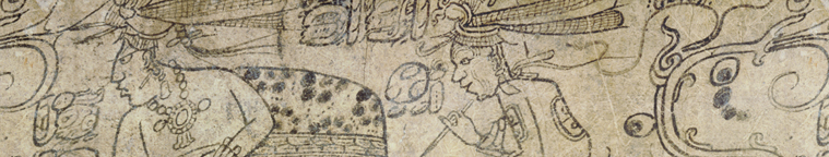
Seeing Maya Splendor
Frederick Catherwood (1799–1854).
Study for Mayan Monument, ca. 1842.
Pencil and brown wash drawing on paper.
Jay I. Kislak Collection, Rare Book and Special Collections Division, Library of Congress (3)
Enlarge
Seeing Maya Splendor
This drawing is one of only a few originals not destroyed by a disastrous fire in a New York gallery in July 1842. John Lloyd Stephens, an outgoing American writer, and Frederick Catherwood, a quiet English artist, were the first explorers to accurately describe and illustrate the art of the pre-Hispanic Maya of Mexico and Central America. Through their highly popular publications (first published in 1841 and 1843 and still in print today), they introduced the ancient Maya to a world that knew little of their existence and stimulated research on the Maya for generations.
Heroic Archaeologist
French archaeologist Claude-Joseph-Desiré Charnay and his team carried heavy photographic equipment into jungles and barely cleared terrain to take these images of the ruins at Uxmal, Mitla, and Chichen Itza (now designated one of the “Seven Wonders of the World”) during the first systematic photographic expeditions to Mexico in 1859–1860. Charnay’s work was instrumental in attracting serious scholarly interest in Europe in pre-conquest Mexico, thus setting the stage for later intensive archaeological studies of Mesoamerican civilization.

Heroic Archaeologist
Claude-Joseph-Désiré Charnay (1828–1915).
Ruines du Mexique et types mexicains [Ruins of Mexico and types of Mexicans]. 1862–1863.
Albumen prints.
Jay I. Kislak Collection, Rare Book and Special Collections Division, Library of Congress (4a)
Enlarge

Heroic Archaeologist
Claude-Joseph-Désiré Charnay (1828–1915).
Ruines du Mexique et types mexicains [Ruins of Mexico and types of Mexicans]. 1862–1863.
Albumen prints.
Jay I. Kislak Collection, Rare Book and Special Collections Division, Library of Congress (4b)
Enlarge

Heroic Archaeologist
Claude-Joseph-Désiré Charnay (1828–1915).
Ruines du Mexique et types mexicains [Ruins of Mexico and types of Mexicans]. 1862–1863.
Albumen prints.
Jay I. Kislak Collection, Rare Book and Special Collections Division, Library of Congress (4c)
Enlarge

Heroic Archaeologist
Claude-Joseph-Désiré Charnay (1828–1915).
Ruines du Mexique et types mexicains [Ruins of Mexico and types of Mexicans]. 1862–1863.
Albumen prints.
Jay I. Kislak Collection, Rare Book and Special Collections Division, Library of Congress (4d)
Enlarge

Fifteenth-Century Venice
“Venecie” from Hartmann Schedel.
Liber chronicum. (Book of chronicles).
Nuremberg: A. Koberger, 1493.
Rare Book and Special Collections Division (7C.2)
Enlarge
Fifteenth-Century Venice
Early Spanish explorers compared the Aztec capital city, Tenochtitlán (now Mexico City) to the Italian city Venice, also a place of impressive buildings constructed on islands connected by canals. Favorably located for handling trade between East and West, the Venetian Republic became a major sea power and one of the most prosperous cities in Europe in the fifteenth century. This 1493 view of Venice from the “Nuremberg Chronicle,” an illustrated history of the earth from creation through the fifteenth century, depicts the palace of the doge (duke), St. Mark’s Basilica, the Campanile (bell tower), and other landmarks that still look much the same.

Cordoba, Spain, ca. 1617
“Corduba,” from Georg Braun and Franz Hogenberg.
Théâtre du cites du monde. [Brussels?: 1576?–1620?].
Geography and Map Division (7E.1)
Enlarge
Cordoba, Spain, ca. 1617
Between the eighth and fifteenth centuries, Muslims called “Moors” ruled parts of what is now Spain. Córdoba became the thriving capital of the Caliphate of Córdoba that governed almost all the Iberian peninsula. In the tenth century, Córdoba was one of the largest cities in Western Europe. The city was conquered by Christian forces under Ferdinand III, King of Castille and Leon, in 1236. The two most important buildings from the Moorish period visible in this view are the Alcazar (Palatium Regium), where Christopher Columbus received royal backing from Ferdinand of Aragon and Isabella of Castille for his voyage to the Americas in 1492, and the Mezquita (Ecclesia Maior), formerly the Aljama Mosque, remodeled as a cathedral in the early sixteenth century.

Rome, ca. 1578
“Roma,” from Georg Braun and Franz Hogenberg.
Théâtre du cites du monde.
[Brussels?: 1576?–1620?].
Geography and Map Division (7E.2)
Enlarge
Rome, ca. 1578
Headquarters of the Roman Empire, and later of the papacy, which made it a center of Renaissance culture, Rome has played a major role in European history. This highly detailed view of sixteenth-century Rome depicts its many ancient ruins, churches, towers, walls, and palaces. Such familiar landmarks as the Colosseum, Pantheon, Castel St. Angelo, and Trajan’s Column are clearly visible and keyed with numbers to a legend at the bottom of the map. The Vatican area, however, has changed greatly since this view was made. The present St. Peter’s Basilica was begun in 1506 but not completed until 1626.

Views of Tenochtitlán and Cusco
Georg Braun and Franz Hogenberg. “Mexico, regia et celebris Hispaniae novae civitas (Mexico, regal and
reknowned state of New Spain)” and “Cusco, regni Peru in novo orbe caput (Cusco, capitol of the kingdom
of Peru in the New World)” in Civitates Orbis Terrarum. (Commonwealths of the world)
Cologne: T.
Graminaeus, 1572.
Jay I. Kislak Collection, Rare Book and Special Collections Division, Library of Congress (5)
Enlarge
Views of TenochtitlÁn and Cusco
Civitates Orbis Terrarum, the first systematic city atlas, depicts cities from around the world, including these two in the Americas. The view of Tenochtitlán, the Aztec capital (site of the present Mexico City) that astonished the conquistadors when they first saw it, is based on a map in the letters of Hernán Cortés (1485–1547) published in 1524.
Important sites are included, such as the marketplace, the sacrificial temple, and palace of Moctezuma. The view is paired with one of Cusco, Peru, the capital city of the Inca Empire. The representation of Cusco shows the square bordered by the Inca palace, the great temple and the homes of senior dignitaries, from which four roads led to the most remote corners of the Inca empire. Dignitaries of the respective empires are depicted in the foreground of each view.

Nanjing, China, in 1400
Jin ling tu yong (The city of Nanjing in 1400).
Nanjing: Zhu Zhifan, 1624.
Rare Book Collection,
Asian Division (7A)
Enlarge
Nanjing, China, in 1400
Nanjing, the capital of China’s present Jiangsu Province, has a prominent place in Chinese history and culture. One of the earliest cities established in eastern China (by legend dating to 495 BC), it served as the country’s capital during several periods. Zhu Yuanzhang (b. 1328, reigned 1368–1398), the founding emperor of the Ming Dynasty, re-established Nanjing as the capital of China in 1368. The city is believed to have been the world’s largest between 1358 and 1425. In 1400, when Nanjing looked as depicted in this image, the population was 487,000. In 1420, the third Ming emperor moved the capital of China from Nanjing to Beijing.

Sixteenth-Century Istanbul
“Byzantium, nunc Constantinopolis” (Byzantium, now Constantinople) from Georg Braun
and Franz Hogenberg.
Théâtre du cites du monde. [Brussels?: 1576?–1620?].
Geography and
Map Division (7E.2)
Enlarge
Sixteenth-Century Istanbul
In its long history, Istanbul (earlier known as Byzantium and Constantinople) has been the capital of the Roman, the Byzantine, the Latin (established by Crusaders who sacked the city), and the Ottoman Empires. Under Sultan Mehmed II (b. 1432, reigned 1444–1446 and 1451–1481), who conquered the city, and his great-grandson, Suleiman the Magnificent (b. 1494, reigned 1520–1566), the city was transformed by new palaces and mosques. Suleiman made the Ottoman Empire one of the world’s foremost powers, with Istanbul as its cultural center. This image from the sixteenth century, the golden age of the Ottoman empire, provides a valuable record of Istanbul’s appearance at that time.

Fabled City of Timbuktu
Réné Caillié. “View of the City of Timbuctoo” from Travels through Central Africa to
Timbuctoo and across the Great Desert to Morocco, performed in the years 1824–1828.
vol 2.
London: Henry Colburn and Richard Bentley, 1830.
General Collections (7F)
Enlarge
Fabled City of Timbuktu
Timbuktu, Mali, long a trading center linking West Africa with merchants throughout North Africa, and thereby indirectly with European traders, achieved fabled status in Europe, becoming a metaphor for exotic, distant lands. Frenchman Réné Caillié (1799–1838), the first European to visit Timbuktu and return, made this drawing of the city in 1828. In order to reach Timbuktu, Caillié learned Arabic and disguised himself as a Muslim. His feat earned him a prize for gaining exact information about Timbuktu, the Legion of Honor, a pension, and other distinctions. His llustrated travel journal was published by the French government in 1830.