
"The want of accurate Maps of the Country which has hitherto been the Scene of War, has been a great disadvantage to me. I have in vain endeavored to procure them and have been obliged to make shift, with such sketches as I could trace from my own Observations . . . ."1
Most Americans are familiar with George Washington's role as the leader of the Continental army against the British forces in the American Revolution or as the first president of the United States, but many may be unaware of Washington's lifelong association with geography and cartography. Beginning with his early career as a surveyor and throughout his life as a soldier, planter, businessman, land speculator, farmer, military officer, and president, Washington relied on and benefitted from his knowledge of maps. Between 1747 and 1799 Washington surveyed over two hundred tracts of land and held title to more than sixty-five thousand acres in thirty-seven different locations. Early in the Revolutionary War, even with the responsibility of leading the army on his shoulders, Washington sometimes found it necessary to make his own field sketches, as the quotation above suggests. Recognizing a need, Washington appointed Robert Erskine as the first geographer to the Continental army in 1777.
Since his death in 1799 more than a thousand biographies have been published exploring various aspects of George Washington's life. Most nineteenth-century works give little attention to Washington's early years, when he worked as a surveyor. The majority of twentieth-century biographies do discuss Washington's surveying and land acquisition, however, and in recent years a number of works have been specifically devoted to the subject.
The George Washington Atlas, initially published in 1932 by the George Washington Bicentennial Committee, was the first attempt to compile a bibliography of maps drawn or annotated by George Washington. The atlas was conceived as part of the nationwide observance of the two hundredth anniversary of Washington's birth and identified 110 extant maps or surveys drawn or annotated by Washington.2 The editor, Colonel Lawrence Martin, chief of the Geography and Map Division, Library of Congress, attempted to list all known Washington maps and brought more than twenty new items to light. These range from Washington's first survey exercise in 1747 to his last survey of the Mount Vernon lands and include pencil sketches, pen and ink drawings, roughly drawn field surveys, and finished survey plats. Recent research has uncovered additional items not included in the 1932 inventory.3
Washington's cartographic career can be divided into two phases: public surveyor and private land speculator. Undoubtedly, the close association with and practical knowledge of the land that Washington gained as both a surveyor and land speculator contributed to his development from surveying apprentice to one of the leaders of Virginia, and later, of the United States.
Washington As Public Land Surveyor: (Top)
Boyhood and Beginnings
George Washington was born February 22, 1732, to Augustine and Mary Ball Washington at Popes Creek Plantation in Westmoreland County, Virginia. When his father died in 1743, eleven-year-old George inherited the small Ferry Farm on the Rappahannock River where he was then living with his mother and siblings, while his older half brother Lawrence Washington inherited the larger farm at the junction of the Little Hunting Creek and Potomac Rivers that he renamed Mount Vernon. As he grew to maturity, young George had little use for the meager prospects at the Ferry Farm plantation. After flirting briefly with the idea of a career in the Royal Navy, he began studying geometry and surveying, using a set of surveyor's instruments from the storehouse at Ferry Farm.
Among the earliest maps attributed to Washington are sample surveys included in Washington's so-called "School Boy Copy Books," housed in the George Washington Papers in the Manuscript Division of the Library of Congress. The schoolbook includes lessons in geometry and several practice land surveys Washington prepared at the age of sixteen. These include a survey of the turnip garden belonging to Lawrence Washington, on whose Mount Vernon estate he had been spending increasing amounts of time. Early in 1748, with as few as three practice surveys under his belt, George Washington accompanied George William Fairfax and James Genn, Surveyor of Prince William County, on a month-long trip west across the Blue Ridge Mountains to survey land for Thomas, Lord Fairfax, 6t Baron Cameron. Although the surveys were actually performed by the more experienced members of the party, the trip was Washington's formal initiation into the field and led him to pursue surveying as a profession. The trip also marked the beginning of a lifelong relationship between Washington and the powerful and influential Fairfax family that gave the young surveyor access to the upper echelons of Virginia society.
Washington As Public Land Surveyor: (Top)
The Fairfax Connection
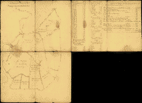
 A survey of the northern neck of Virginia, 1747 |
In the Northern Neck of Virginia, the extensive region between the Rappahannock and Potomac Rivers, land matters were governed by the Proprietor, Lord Fairfax, and his Virginia representative and first cousin, William Fairfax, through the Northern Neck Proprietary Office. In 1649 King Charles II of England had deeded five million acres lying between the rivers to a group of loyal supporters, including the Fairfax family. Through death and marriage the land was consolidated under one man, Thomas, Lord Fairfax, who established his seat at Belvoir, approximately four miles upstream from Mount Vernon. Later, he moved west of the Blue Ridge Mountains to Greenway Court in Frederick (now Clarke) County, Virginia.4
Prospective settlers in the Northern Neck were required to obtain a survey warrant from the Northern Neck Proprietary Office for a set amount of acreage in a specific location. The survey warrant, issued directly from the Northern Neck Land Office to the county surveyor, instructed the surveyor to make a "just and true" survey of the land, thereby officially determining and limiting its boundaries. Because they were responsible for laying out the land claims, surveyors had a unique role in Virginia society. Their appointments guaranteed a certain social prominence, since nearly all parties interested in gaining title to an area of land were required to deal with the surveyor. Surveyors were also among the best-educated Virginians and were often in the best position to purchase land for themselves. It was not unusual for surveyors to acquire large estates from the many opportunities they had to patent land in their own names. Additionally, their intimate knowledge of the land and official capacity as representatives of large land holders such as the Fairfaxes made their participation politically and practically essential to large land companies such as the Loyal Land Company of Virginia, the Ohio Company, and the Mississippi Land Company.5
In July 1749, at seventeen years of age and largely through the Fairfax influence that he had cultivated, Washington secured an appointment as county surveyor for the newly created frontier county of Culpeper, where he served until November 1750. He then continued to work in the Northern Neck with the permission of the Fairfax family from November 1750 to November 1752.6 During his three years on the frontier he established a reputation for fairness, honesty, and dependability, while earning a very decent living. Philander Chase, the current editor of the Washington Papers at the University of Virginia, writes that frontier surveyors "could earn an annual cash income that was exceeded only by the colony's finest trial lawyers."7 From the records documenting the 199 professional surveys attributed to Washington it is clear that he did not confine himself to Culpeper County, even while he served as its official surveyor. Rather, Washington did the majority of his surveying in Frederick and Hampshire Counties, the westernmost counties of the Northern Neck. Partly because of his close relationship with the Fairfax family, he may have had a distinct advantage over other Northern Neck surveyors
Washington As Public Land Surveyor: (Top)
Culpeper, the Frontier, and Alexandria
Of the 199 surveys credited to Washington, fewer than seventy-five are extant today.8 All display a finished, stylized, and symmetrical appearance. The Geography and Map Division of the Library of Congress has several examples of Washington surveys, including a November 17, 1750, survey plat for John Lindsey of 460 acres along the Great Cacapon River, on which Washington used the initials "S.C.C.," Surveyor of Culpeper County, to denote his official role. This is one of the last survey plats Washington prepared in his capacity as county surveyor.
In addition to the public surveys he made on the western frontiers of the Northern Neck, Washington prepared two remarkable maps of the area that became the city of Alexandria, Virginia, on the Potomac River. The earliest is the Plat of the Land whereon now Stands the Town of Alexandria, drawn in 1748. As the title suggests, this map is a simple outline of the future town, with the land area annotated as "Area 51 acres, 3 Roods, 31 Perch." The site map shows the location of existing structures such as a tobacco-inspection warehouse and includes notes on the land within the proposed town limits indicating its suitability for use. The map also provides soundings and shoal locations in the river, information vital to the operation of any port city. The absence of a street grid suggests that the map may have been drawn sometime between March 1748 and July 1749, when the town of Alexandria was formally incorporated.
 George Washington's survey of the site of
Belhaven (Alexandria) Virginia, 1748.
George Washington's survey of the site of
Belhaven (Alexandria) Virginia, 1748. |

Plan of Alexandria, Now Belhaven, 1749 |
The second map, entitled Plan of Alexandria, Now Belhaven, includes a street grid but, as the title suggests, may have been made just before the town's incorporation, when it was still known by its earlier name of Belhaven. This map may have been used for the sale of lots, which took place on July 14 and 15, 1749. It lists the name of the holder of each lot, its location, and the price paid for it. The names of Washington's older half brothers, Lawrence and Augustine, of William Fairfax, and of George William Fairfax appear on the list.
Based on these maps, some have erroneously concluded that Washington personally designed or was at least heavily involved in the city's formation. While both maps are clearly in Washington's hand, no documentary evidence supports this claim. As he had with the maps he prepared during his first surveying trip, Washington probably derived or copied these from originals drawn by someone else--in this case John West Jr., Deputy Surveyor of Fairfax County, who is generally credited with the actual surveys. 9
Washington As Public Land Surveyor: (Top)
The French and Indian War
Washington's decisive involvement in the French and Indian War, in which he served as lieutenant colonel of the newly formed Virginia Regiment, was due in part to the backcountry knowledge and map-making skills he had gained from surveying. In 1753, one year before Lieutenant Governor Dinwiddie called for additional troops under Washington's command to defend Virginia's Ohio Valley frontier, Washington was chosen to deliver an ultimatum to the French at Fort Le Boeuf (site of present-day Waterford, Pennsylvania), insisting that they withdraw from the valley. When his report of this venture, The Journal of Major George Washington, was printed in Williamsburg and then reprinted in London, it catapulted him onto the world stage.
Although an engraved map was issued with the London edition of his journal, Washington prepared a sketch map of his journey to accompany the original publication.10 There are three known manuscript versions of this historically important map, two housed in the British Public Record Office and one in a private collection. Although older published maps were available to British colonial interests, this sketch map alone represents the state of geographical knowledge at the outbreak of the war. Together with Washington's report, the map dramatically illustrates the French threat in the Ohio Valley. It also contains one of the first references to the construction of a strategic fort at the junction of the Monongahela and Allegheny Rivers, the site of present-day Pittsburgh. Washington's role in beginning the French and Indian War seems to have been inescapable. He not only volunteered to deliver the message to the French authorities but produced a propaganda map highlighting the French threat and ambushed a French detachment in the war's first skirmish in 1754.
Washington As Land Speculator: (Top)
Building a Gentleman's Estate
In 1752 Washington made his first land purchase, 1,459 acres along Bullskin Creek in Frederick County, Virginia. This act inaugurated the second and more profitable phase of his cartographic career, in which he assumed the role of land speculator. Over the next half century Washington would continue to seek out, purchase, patent, and eventually settle numerous properties. His will, executed in 1800, lists 52,194 acres to be sold or distributed in Virginia, Pennsylvania, Maryland, New York, Kentucky, and the Ohio Valley. In addition to these properties, Washington also held title to lots in the Virginia cities of Winchester, Bath (now Berkeley Springs, West Virginia), and Alexandria, and in the newly formed City of Washington.
 A Plan of Mr. Clifton's Neck Land, 1760 |
In 1758 Washington left military service and returned to civilian life and in January 1759 married Martha Custis, a wealthy widow. No sooner had the couple settled at Mount Vernon, which had become Washington's home, than he begin to expand the estate. In 1760 a neighbor, William Clifton, approached Washington with an offer to sell a 1,806-acre tract on the northern border of the estate, and the two men settled on a price of £1,150 sterling. Shortly afterwards, however, Clifton agreed to sell the same tract of land to another neighbor, Thomson Mason, for a slightly higher price. Despite Clifton's original agreement and a series of angry letters, Washington eventually paid £1,250 sterling to secure the land for himself.11 The area became the Washingtons' River Farm.
The Geography and Map Division has two manuscript maps that Washington drew of the land he purchased from Clifton. The earlier is a map Washington copied in 1760, presumably during the purchase of the property. Titled Plan of Mr. Clifton's Neck Land from an original made by T.H. in 1755 and copied by G. Washington in 1760, the map includes survey courses and distances of the perimeter and of each field under cultivation in the tract. The map also includes a lengthy list of farmers working the property. In 1766 Washington prepared a map of a much smaller portion of the property, entitled A Plan of My Farm on Little Hunting Creek. This map covers an 846-acre portion between Little Hunting Creek and the smaller Poquoson Creek. Both items are among the earliest extant maps of individual farms at Mount Vernon.
Over the course of his life, Washington maintained an interest in his farm, even while serving as President. Between 1786 and 1799 Washington exchanged nearly thirty letters with Arthur Young, a British agricultural supporter, in an attempt to refine and improve his farming methods. In a December 12, 1793 letter to Young, Washington enclosed a map of his farms which described the total amount of acreage on the Union, Dogue Run, Muddy Hole, Mansion House, and River Farms as well as the type of crops under cultivation.
Washington As Land Speculator: (Top)
Western Lands and the Bounty of War
Washington's lifelong interest in land speculation is illustrated in the fight over bounty lands promised to the veterans of the Virginia Regiment who fought with him in the French and Indian War. In this episode Washington acted on behalf of his fellow veterans as well as vigorously, sometimes aggressively, in staking out his own land claims.
In 1754, Lieutenant Governor Dinwiddie issued a proclamation designed to encourage enlistment in the local militia for the war against the French. In addition to their pay, those who enlisted in Lieutenant Colonel George Washington's fledgling Virginia Regiment were offered a share in two hundred thousand acres west of the Ohio River. Unfortunately for the men who fought under Washington in the Braddock and Forbes expeditions against the enemy at Fort Duquesne, they were not to see these bounty lands until more than twenty years had passed, during which time Washington led the struggle to secure their title.
At first, the formal conclusion in 1763 of the worldwide war between Britain and France, of which the French and Indian War had been a part, aroused hope that the land would be quickly granted. These expectations were overshadowed by the Royal Proclamation of 1763 which (among other provisions) forbade colonial governors from issuing land grants west of the Allegheny Mountains. Yet Washington chose to forge ahead, as evinced by a September 1767 letter to William Crawford, a Pennsylvania surveyor:
. . . I can never look upon the Proclamation in any other light (but this I say between ourselves) than as a temporary expedient to quiet the minds of the Indians. It must fall, of course, in a few years, especially when those Indians consent to our occupying those lands. Any person who neglects hunting out good lands, and in some measure marking and distinguishing them for his own, in order to keep others from settling them will never regain it. If you will be at the trouble of seeking out the lands, I will take upon me the part of securing them, as soon as there is a possibility of doing it and will, moreover, be at all the cost and charges surveying and patenting the same . . . . By this time it be easy for you to discover that my plan is to secure a good deal of land. You will consequently come in for a handsome quantity.12
Washington was clearly willing to take considerable risks in seeking out choice land for himself. In the same letter, however, he warned Crawford "to keep the whole matter a secret, rather than give the alarm to others or allow himself to be censured for the opinion I have given in respect to the King's Proclamation." He concluded by offering Crawford an alibi should his behavior be called into question. "All of this can be carried on by silent management and can be carried out by you under the guise of hunting game, which you may, I presume, effectually do, at the same time you are in pursuit of land. When this is fully discovered advise me of it, and if there appears a possibility of succeeding, I will have the land surveyed to keep others off and leave the rest to time and my own assiduity." In fact, the letter marked the beginning of a very profitable fifteen-year partnership. Less than two weeks after he had received it, Crawford informed Washington about several tracts in the vicinity of Fort Pitt, and the two men continued to collaborate until Crawford's death in 1782.
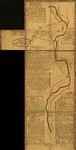 Eight survey tracts along the Kanawha River, 1774? |
Washington persisted in his attempts to secure the military bounty lands. In 1769, Governor Botetourt of Virginia at last gave him permission to seek out a qualified surveyor and to notify all claimants that surveying would proceed. Once the surveying was completed the land could be divided among the remaining Virginia Regiment veterans or their heirs. Washington arranged to have Crawford appointed the "Surveyor of the Soldiers Land." In the fall of 1770 Washington, Crawford, and a fellow veteran named Dr. James Craik set out from Fort Pitt by canoe to explore possible sites for the bounty lands, making notes and observations as they journeyed to the junction of the Ohio and Great Kanawha Rivers and several miles up the Great Kanawha.
The next year, Crawford began to survey the tracts he and Washington had identified on the Great Kanawha expedition. Eight of these tracts are shown on a composite map now in the collections of the Geography and Map Division that Washington drew in1774 from Crawford's surveys. Out of a total of 64,071 acres apportioned on the map, 19,383, or approximately 30 percent, were patented in Washington's name. In a 1794 letter to Presley Neville, Washington said that these lands were "the cream of the Country in which they are; that they were the first choice of it; and that the whole is on the margin of the Rivers and bounded thereby for 58 miles."13In addition to Washington's acreage the map shows the lands surveyed and apportioned to other Virginia Regiment members, including Colonel Joshua Fry, Colonel Adam Stephen, Dr. James Craik, George Mercer, George Muse, Colonel Andrew Lewis, Captain Peter Hog, Jacob Van Braam, and John West. Several of these individuals were distinguished in their own right. Joshua Fry, for example, was one half of the team which produced the well-known 1755 Map of Inhabited Parts of the State of Virginia, considered to be one of the finest examples of colonial mapping; Jacob Van Braam had been Washington's interpreter at Fort Necessity in the French and Indian War; and Dr. James Craik was Washington's lifelong friend and physician.
Washington As Land Speculator: (Top)
Cartography and Leadership in Revolutionary Times
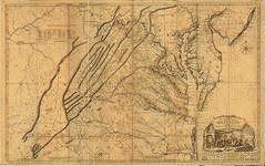 A map of the most inhabited part of Virginia, 1755 |
Washington died at Mount Vernon on December 14, 1799. In 1810 the executors of his estate prepared an inventory of Mount Vernon's contents. While Washington had a fairly extensive library, he was not a voracious reader and probably acquired many of the volumes as gifts. The library inventory listed more than ninety maps and atlases, including John Henry's 1777 Map of Virginia; Joshua Fry and Peter Jefferson's Map of the State of Virginia; Reading Howell's 1777 Map of Pennsylvania; Thomas Hutchins's Map of the Western Part of Parts of Virginia, Pennsylvania, Maryland and North Carolina; Lewis Evans's Map of Pennsylvania, New Jersey, New York, and Delaware; "Sundry Plans of the Federal District" (including "One Large Draft"); Thomas Jefferys's West India Atlas and American Atlas; Molls Atlas; William Faden's North America Atlas; Christopher Colles's 1789 Survey of the Roads of the United States; and Jedidiah Morse's 1789 American Geography. These items might be found on any serious map collector's list of desiderata today.16
Jedidiah Morse is remembered not only for publishing the first geographic work in America, but for a short section in his 1789 American Geography that (according to the historian Rosemarie Zagarri) is actually the first and only authorized biography of Washington. Colonel David Humphreys, one of Washington's aides-de-camp during the American Revolution, originally conceived the project as a full-scale biography to be edited by Washington himself, but it was never finished. At some point Morse received a summary and published it in American Geography without attribution.17 Given Washington's experience organizing the western frontiers of Virginia as a public surveyor, the impact of the map and report he made of his expedition to the Ohio Valley in 1754, and his lifelong involvement with the making and using of maps, it is altogether fitting that he should have been celebrated in the first American geography.
Edward Redmond
Senior Reference Librarian
Geography and Map Division
Library of Congress
Washington, DC
ENDNOTES (Top)
1. John C. Fitzpatrick, ed., Writings of George Washington from the Original Manuscript Sources, 1745-1799, ed. (Washington, D.C.: Government Printing Office, 1931-44), 7:65.
[Back to Text]
2. Lawrence Martin, ed., The George Washington Atlas (Washington, D.C.: United States George Washington Bicentennial Commission, 1932), vol. 1. The atlas was prepared in the course of one year and was published as a folio edition in February 1932. An expanded quarto edition appeared later in 1932 and was published in the first volume of the History of the George Washington Bicentennial Celebration (Washington, D.C.: United States George Washington Bicentennial Commission, 1932). The folio edition was reprinted in 1995 by the Virginia Surveyors Association.
[Back to Text]
3. Edward J. Redmond, "George Washington's Activities in Securing Land Grants along the Western Frontiers of Virginia 1767-1799 and List of Maps Drawn or Annotated by George Washington" (master's thesis, West Chester University, 1991). Prepared from the list compiled by Martin.
[Back to Text]
4. Josiah Look Dickinson, The Fairfax Proprietary: The Northern Neck, the Fairfax Manors, and the Beginnings of Warren County. (Front Royal, VA: The Warren Press, 1959) p. 1.
[Back to Text]
5. Sarah Hughes, Surveyors and Statesmen: Land Measuring in Colonial Virginia (Richmond: Virginia Surveyors Association and The Virginia Association of Surveyors, 1979), p. 163.
[Back to Text]
6. Hughes, 93.
[Back to Text]
7. Philander Chase, "A Stake in the West: George Washington As Backcountry Surveyor and Landholder," in George Washington and the Virginia Backcountry, ed. Warren Hofstra (Madison, Wis.: Madison House Publishers, 1998), 161.
[Back to Text]
8. Ibid, 160.; Redmond, p. 18
[Back to Text]
9. P.L. Phillips, "Washington as Surveyor and Map Maker," Daughters of the American Revolution Magazine, 55 (March 1921):115-32.
[Back to Text]
10. The map that appeared in the London edition of Washington's journal was Thomas Jefferys's 1754 Map of the Western Parts of the Colony of Virginia. This map is apparently an enlarged version of an earlier map engraved by John Gibson with the same title (Geography and Map Division call number G3880 1754 .M Vault) that was published in the London Magazine, June 1754. For a reproduction of Jefferys's map as well as other maps relating to the French and Indian War, see Seymour I. Schwartz, The French and Indian War,1754-1763: The Imperial Struggle for North America (New York: Simon & Schuster, 1994).
[Back to Text]
11. W.W. Abbot, ed., The Papers of George Washington: Colonial Series (Charlottesville: University Press of Virginia, 1983-94), 6:407-11.
[Back to Text]
12. George Washington to William Crawford, September 20, 1767, George Washington Papers, Manuscript Division, Library of Congress. For the full correspondence between Washington and William Crawford and his brother Valentine Crawford, see C. W. Butterfield, The Washington-Crawford Letters (Cincinnati: R. Clarke & Co., 1877).
[Back to Text]
13. George Washington to Presley Neville, June 6, 1794, George Washington Papers, Manuscript Division, Library of Congress.
[Back to Text]
14. For additional information on Robert Erskine, see Albert Huesser, George Washington's Map Maker (New Brunswick, N. J.: Rutgers University Press, 1966). A detailed account of the maps William Scull produced while he was working under Erskine and his successor, Simeon De Witt, that are now in the collections of the New-York Historical Society can be found in Peter J. Guthorn, American Maps and Map Makers of the Revolution (Monmouth Beach, N.J.: Philip Freneau Press, 1966).
[Back to Text]
15. Walter W. Ristow, American Maps and Map Makers (Detroit: Wayne State University Press, 1985), 37. See also chapter 5 of this work, "Simeon De Witt, Pioneer Cartographer," for a detailed discussion of De Witt's impact on American cartography.
[Back to Text]
16. Appendix 2 in Eugene D. Prussing, The Estate of George Washington, Deceased (Boston: Little, Brown, and Company, 1927), 401. For additional information on Washington's library at Mount Vernon, see Joseph M.. Toner, Some Accounts of George Washington's Library and Manuscript Records and Their Dispersion from Mount Vernon (Washington, D.C.: Government Printing Office, 1894).
[Back to Text]
17. Rosemarie Zagarri, ed., David Humphreys' "Life of General Washington" with George Washington's "Remarks" (Athens: University of Georgia Press, 1991). For biographical information on Morse, see Ralph E. Brown, "The American Geographies of Jedidiah Morse,"
[Back to Text]
Annals of the Association of American Geographers 23, no. 3 (September 1941): 147.