|
|
 |
|
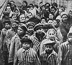
BE A WITNESS The Museum’s Mapping Initiatives use tools such as Google Earth and animated maps to enable citizens to understand Holocaust history and to bear witness to current threats of genocide across the globe. The Holocaust took place across the entire European continent, and for all of Europe's Jews, as well as other victims of Nazism, geography played a major role in determining their fate. The Holocaust Mapping Initiative overlays key Holocaust sites and historic content from the Museum's collections on Google Earth and other maps. The Genocide Prevention Mapping Initiative brings together data, photographs, video, and eyewitness testimony in Google Earth to help inform citizens, governments, and institutions about current and potential genocides and related crimes against humanity, and to respond. Download and install Google Earth |

|
|||||||||
|
MAPPING INITIATIVES
 |
||||||||||