- Identification_Information:
-
- Citation:
-
- Citation_Information:
-
- Originator: U.S. Geological Survey (USGS), Coastal and Marine Geology (CMG)
- Publication_Date: 20081216
- Title:
-
Geophysical data of field activity W-18-75-NP in CA-OR-WA
(COW) MINI CABLE 1975 from 00/00/1975 to 00/00/1975
- Publication_Information:
-
- Publisher: U.S. Geological Survey (USGS), Coastal and Marine Geology (CMG)
- Online_Linkage: <http://walrus.wr.usgs.gov/infobank/gos/w-18-75-np.fmeta.xml>
- Online_Linkage:
-
<http://walrus.wr.usgs.gov/infobank/w/w1875np/html/w-18-75-np.meta.html>
- Description:
-
- Abstract:
-
WesternGeco. Geophysical data (navigation, seismic) of field
activity W-18-75-NP in CA-OR-WA (COW) MINI CABLE 1975 from
00/00/1975 to 00/00/1975,
<http://walrus.wr.usgs.gov/infobank/w/w1875np/html/w-18-75-np.meta.html>.
- Purpose:
-
These data and information are intended for science
researchers, students from elementary through
college, policy makers, and general public.
- Supplemental_Information:
-
Equipment Used -
navigation data directory exists
seismic data directory exists
Notes -
DESCRIPTION OF SURVEY AREA 118: CA-OR-WA (COW) MINI CABLE 1975<br>
<p>
CLIENT NAME WESTERNGECO MULTICLIENT<br>
COORDINATE LOCATION ANTENNA LOCATIONS<br>
SPHEROID DEFINITION - SURVEYCLARKE (1866) 6378206.400 294.9786985<br>
SPHEROID DEF. - POST PLOT CLARKE (1866) 6378206.400 294.9786985<br>
GEODETIC DATUM - SURVEY NAD 1927 <br>
GEODETIC DATUM - POST PLOT NAD 1927 <br>
<p>
DATUM SHIFTS <br>
PROJECTION TYPE LAMBERT<br>
GRID SYSTEM CALIFORNIA ZONE 1<br>
GRID UNITS U.S. SURVEY FEET <br>
STANDARD PARALLELS 4000 0.000N 4140 0.000N<br>
CENTRAL MERIDIAN 12200 0.000W<br>
GRID ORIGIN 3920 0.000N12200 0.000W<br>
GRID COORDINATES AT ORIGIN 2000000.00E 0.00N <br>
<p>
Similar information is available for thousands
of other USGS/CMG-related Activities.
If known, available are Activity-specific
navigation, gravity, magnetics, bathymetry,
seismic, and sampling data; track maps; and
equipment information; as well as summary
overviews, crew lists, and information
about analog materials.
If available, access to physical samples is
described in the "WR CMG Sample Distribution
Policy" at:
<http://walrus.wr.usgs.gov/infobank/programs/html/main/sample-dist-policy.html>
Primary access to the USGS/CMG Information
Bank's digital data, analog data, and
metadata is provided through...
<http://walrus.wr.usgs.gov/infobank/>
This page accomodates a variety of search
approaches (e.g., by platform, by region,
by scientist, by equipment type, etc.).
- Time_Period_of_Content:
-
- Time_Period_Information:
-
- Range_of_Dates/Times:
-
- Beginning_Date: 19750000
- Ending_Date: 19750000
- Currentness_Reference: ground condition
- Status:
-
- Progress: Complete
- Maintenance_and_Update_Frequency: As needed
- Spatial_Domain:
-
- Bounding_Coordinates:
-
- West_Bounding_Coordinate: -125.47044
- East_Bounding_Coordinate: -121.92582
- North_Bounding_Coordinate: 48.53025
- South_Bounding_Coordinate: 36.21951
- Keywords:
-
- Theme:
-
- Theme_Keyword_Thesaurus: ISO 19115 Topic Category
- Theme_Keyword: geoscientificinformation
- Theme_Keyword: oceans
- Theme:
-
- Theme_Keyword_Thesaurus: USGS CMG InfoBank
- Theme_Keyword: Marine Geology
- Theme_Keyword: Marine Geophysics
- Theme_Keyword: Marine Seismic
- Place:
-
- Place_Keyword_Thesaurus: USGS CMG InfoBank
- Place_Keyword: CA-OR-WA (COW) MINI CABLE 1975
- Place_Keyword: North Pacific Ocean
- Place_Keyword: Northern Pacific Ocean
- Place_Keyword: Pacific Coast, US
- Access_Constraints:
-
Physical materials are under controlled on-site access.
If available, access to physical samples is described
in the "WR CMG Sample Distribution Policy" at:
<http://walrus.wr.usgs.gov/infobank/programs/html/main/sample-dist-policy.html>
- Use_Constraints:
-
Please recognize the U.S. Geological Survey (USGS) as
the source of this information.
Physical materials are under controlled on-site access.
Some USGS information accessed through this means
may be preliminary in nature and presented without
the approval of the Director of the USGS. This
information is provided with the understanding
that it is not guaranteed to be correct or complete
and conclusions drawn from such information are
the responsibility of the user.
This information is not intended for navigational
purposes.
Any use of trade, firm, or product names is for
descriptive purposes only and does not imply
endorsement by the U.S. Government.
- Point_of_Contact:
-
- Contact_Information:
-
- Contact_Organization_Primary:
-
- Contact_Organization: U.S. Geological Survey (USGS), Coastal and Marine Geology (CMG)
- Contact_Person: Clint Steele
- Contact_Position: Data Acquisition, Processing, and Storage (DAPS) Group Leader
- Contact_Address:
-
- Address_Type: mailing and physical address
- Address: USGS, MailStop 999, 345 Middlefield Road
- City: Menlo Park
- State_or_Province: CA
- Postal_Code: 94025-3561
- Country: USA
- Contact_Voice_Telephone: (650) 329-5055
- Contact_Facsimile_Telephone: (650) 329-5190
- Contact_Electronic_Mail_Address: csteele@usgs.gov
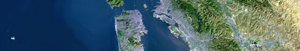
- Browse_Graphic:
-
- Browse_Graphic_File_Name:
-
<http://walrus.wr.usgs.gov/infobank/w/w1875np/html/w-18-75-np.nav.gif>
- Browse_Graphic_File_Description: Trackline map of W-18-75-NP
- Browse_Graphic_File_Type: GIF
- Native_Data_Set_Environment: Digital, ASCII
- Cross_Reference:
-
- Citation_Information:
-
- Originator: U.S. Geological Survey (USGS), Coastal and Marine Geology (CMG)
- Publication_Date: Unknown
- Title: USGS/CMG Information Bank
- Publication_Information:
-
- Publisher: U.S. Geological Survey (USGS), Coastal and Marine Geology (CMG)
- Other_Citation_Details: Updated daily
- Online_Linkage: <http://walrus.wr.usgs.gov/infobank/>
- Data_Quality_Information:
-
- Attribute_Accuracy:
-
- Attribute_Accuracy_Report: Identified as best available version.
- Logical_Consistency_Report: Unspecified
- Completeness_Report:
-
Start and end date/times of data
Navigation Data (w-18-75-np.051 [SINS])
YYYYMMDDHHMMSST    YYYYMMDDHHMMSST
197501010000001    197501010026549
197501020000001    197501020003088
197501030000001    197501030034365
197501040000001    197501040003010
197501050000001    197501050003083
197501060000001    197501060003047
197501070000001    197501070003011
197501080000001    197501080001155
197501090000001    197501090002539
197501100000001    197501100003098
197501110000001    197501110003023
197501120000001    197501120003019
197501130000001    197501130002362
197501140000001    197501140003413
197501150000001    197501150002592
197501160000001    197501160002347
197501170000001    197501170002454
197501180000001    197501180003053
197501190000001    197501190004050
197501200000001    197501200003001
197501210000001    197501210003572
197501220000001    197501220003065
197501230000001    197501230002520
197501240000001    197501240004110
197501250000001    197501250002496
197501260000001    197501260003562
197501270000001    197501270002326
197501280000001    197501280003196
YYYYMMDDHHMMSST    YYYYMMDDHHMMSST
Seismic Shots Data (w-18-75-np.420_051)
YYYYMMDDHHMMSST    YYYYMMDDHHMMSST
197501010000001    197501010026549
197501020000001    197501020003088
197501030000001    197501030034365
197501040000001    197501040003010
197501050000001    197501050003083
197501060000001    197501060003047
197501070000001    197501070003011
197501080000001    197501080001155
197501090000001    197501090002539
197501100000001    197501100003098
197501110000001    197501110003023
197501120000001    197501120003019
197501130000001    197501130002362
197501140000001    197501140003413
197501150000001    197501150002592
197501160000001    197501160002347
197501170000001    197501170002454
197501180000001    197501180003053
197501190000001    197501190004050
197501200000001    197501200003001
197501210000001    197501210003572
197501220000001    197501220003065
197501230000001    197501230002520
197501240000001    197501240004110
197501250000001    197501250002496
197501260000001    197501260003562
197501270000001    197501270002326
197501280000001    197501280003196
YYYYMMDDHHMMSST    YYYYMMDDHHMMSST
- Positional_Accuracy:
-
- Horizontal_Positional_Accuracy:
-
- Horizontal_Positional_Accuracy_Report: Unspecified
- Vertical_Positional_Accuracy:
-
- Vertical_Positional_Accuracy_Report: Unspecified
- Lineage:
-
- Process_Step:
-
- Process_Description:
-
Navigation Data
07/07/2004 clint w-18-75-np.051
/infobank/programs/time/lines2times/lines2times
Integrated navigation (SINS) data
times are fake

Input was...
year,day,hr,min,sec,tenths,lat,long,line,shot,easting,northing,depth
- Process_Date: 20040707
- Process_Contact:
-
- Contact_Information:
-
- Contact_Organization_Primary:
-
- Contact_Organization: U.S. Geological Survey (USGS), Coastal and Marine Geology (CMG)
- Contact_Person: Clint Steele
- Contact_Position: Data Acquisition, Processing, and Storage (DAPS) Group Leader
- Contact_Address:
-
- Address_Type: mailing and physical address
- Address: USGS, MailStop 999, 345 Middlefield Road
- City: Menlo Park
- State_or_Province: CA
- Postal_Code: 94025-3561
- Country: USA
- Contact_Voice_Telephone: (650) 329-5055
- Contact_Facsimile_Telephone: (650) 329-5190
- Contact_Electronic_Mail_Address: csteele@usgs.gov
- Spatial_Data_Organization_Information:
-
- Indirect_Spatial_Reference: CA-OR-WA (COW) MINI CABLE 1975
- Direct_Spatial_Reference_Method: Point
- Point_and_Vector_Object_Information:
-
- SDTS_Terms_Description:
-
- SDTS_Point_and_Vector_Object_Type: Point
- Spatial_Reference_Information:
-
- Horizontal_Coordinate_System_Definition:
-
- Geographic:
-
- Latitude_Resolution: 0.00001
- Longitude_Resolution: 0.00001
- Geographic_Coordinate_Units: Decimal degrees
- Geodetic_Model:
-
- Horizontal_Datum_Name: North American Datum of 1927
- Ellipsoid_Name: Clarke 1866
- Semi-major_Axis: 6378206.4
- Denominator_of_Flattening_Ratio: 294.98
- Vertical_Coordinate_System_Definition:
-
- Depth_System_Definition:
-
- Depth_Datum_Name: Local surface
- Depth_Resolution: 0.1
- Depth_Distance_Units: meters
- Depth_Encoding_Method: Attribute values
- Entity_and_Attribute_Information:
-
- Overview_Description:
-
- Entity_and_Attribute_Overview: Navigation with Time Stamp
- Entity_and_Attribute_Detail_Citation:
-
Integrated navigation (SINS) data
Mnemonic:       (Year, Day, Hour, Min, Sec, Tenths, Latitude, Longitude)
FORTRAN format: (i4.4, i3.3, 3i2.2, i1.1, t16, f9.5, t26, f10.5)
C format:       (%4.4i%3.3i3%2.2i%1.1i %9.5f %10.5f\\n)
Naming:         .050
- Overview_Description:
-
- Entity_and_Attribute_Overview: Seismic Shots with Time Stamp
- Entity_and_Attribute_Detail_Citation:
-
Edited seismic shot point data
Mnemonic:       (Year, Day, Hour, Min, Sec, Tenths, Line, Shot)
FORTRAN format: (i4.4, i3.3, 3i2.2, i1.1, t16, a5, t22, i5)
C format:       (%4.4i%3.3i3%2.2i%1.1i %5s %5i\\n)
Naming:         .420
- Distribution_Information:
-
- Distributor:
-
- Contact_Information:
-
- Contact_Organization_Primary:
-
- Contact_Organization: U.S. Geological Survey (USGS), Coastal and Marine Geology (CMG)
- Contact_Person: Clint Steele
- Contact_Position: Data Acquisition, Processing, and Storage (DAPS) Group Leader
- Contact_Address:
-
- Address_Type: mailing and physical address
- Address: USGS, MailStop 999, 345 Middlefield Road
- City: Menlo Park
- State_or_Province: CA
- Postal_Code: 94025-3561
- Country: USA
- Contact_Voice_Telephone: (650) 329-5055
- Contact_Facsimile_Telephone: (650) 329-5190
- Contact_Electronic_Mail_Address: csteele@usgs.gov
- Resource_Description: Downloadable Data W-18-75-NP data set
- Distribution_Liability:
-
Please recognize the U.S. Geological Survey (USGS) as
the source of this information.
Physical materials are under controlled on-site access.
Some USGS information accessed through this means
may be preliminary in nature and presented without
the approval of the Director of the USGS. This
information is provided with the understanding
that it is not guaranteed to be correct or complete
and conclusions drawn from such information are
the responsibility of the user.
This information is not intended for navigational
purposes.
Any use of trade, firm, or product names is for
descriptive purposes only and does not imply
endorsement by the U.S. Government.
- Standard_Order_Process:
-
- Digital_Form:
-
- Digital_Transfer_Information:
-
- Format_Name: ASCII
- File_Decompression_Technique: No compression applied
- Transfer_Size: 8.1
- Digital_Transfer_Option:
-
- Online_Option:
-
- Computer_Contact_Information:
-
- Network_Address:
-
- Network_Resource_Name:
-
<http://walrus.wr.usgs.gov/infobank/w/w1875np/html/w-18-75-np.nav.html>
- Digital_Form:
-
- Digital_Transfer_Information:
-
- Format_Name: ASCII
- File_Decompression_Technique: No compression applied
- Transfer_Size: 8.1
- Digital_Transfer_Option:
-
- Online_Option:
-
- Computer_Contact_Information:
-
- Network_Address:
-
- Network_Resource_Name:
-
<http://walrus.wr.usgs.gov/infobank/w/w1875np/html/w-18-75-np.seis.html>
- Fees: None
- Metadata_Reference_Information:
-
- Metadata_Date: 20081216
- Metadata_Contact:
-
- Contact_Information:
-
- Contact_Organization_Primary:
-
- Contact_Organization: U.S. Geological Survey (USGS), Coastal and Marine Geology (CMG)
- Contact_Person: Clint Steele
- Contact_Position: Data Acquisition, Processing, and Storage (DAPS) Group Leader
- Contact_Address:
-
- Address_Type: mailing and physical address
- Address: USGS, MailStop 999, 345 Middlefield Road
- City: Menlo Park
- State_or_Province: CA
- Postal_Code: 94025-3561
- Country: USA
- Contact_Voice_Telephone: (650) 329-5055
- Contact_Facsimile_Telephone: (650) 329-5190
- Contact_Electronic_Mail_Address: csteele@usgs.gov
- Metadata_Standard_Name: FGDC Content Standards for Digital Geospatial Metadata
- Metadata_Standard_Version: FGDC-STD-001-1998
- Metadata_Time_Convention: universal time
- Metadata_Access_Constraints: none
- Metadata_Use_Constraints: none
|


