- Identification_Information:
-
- Citation:
-
- Citation_Information:
-
- Originator: U.S. Geological Survey (USGS), Coastal and Marine Geology (CMG)
- Publication_Date: 20081216
- Title:
-
Geophysical data of field activity L-8-76-NP in Northern
Pacific from 09/29/1976 to 10/21/1976
- Publication_Information:
-
- Publisher: U.S. Geological Survey (USGS), Coastal and Marine Geology (CMG)
- Online_Linkage: <http://walrus.wr.usgs.gov/infobank/gos/l-8-76-np.fmeta.xml>
- Online_Linkage:
-
<http://walrus.wr.usgs.gov/infobank/l/l876np/html/l-8-76-np.meta.html>
- Description:
-
- Abstract:
-
Chief Scientist: Brent Dalrymple. Geophysical data
(3dot5khz, 12khz, airgun, RhoRho, dopplersonar,
integratednavigation, transitsatellite, gravity, gradiometer,
uniboom, sonobuoy, chaindredge) of field activity L-8-76-NP
in Northern Pacific from 09/29/1976 to 10/21/1976,
<http://walrus.wr.usgs.gov/infobank/l/l876np/html/l-8-76-np.meta.html>.
- Purpose:
-
These data and information are intended for science
researchers, students from elementary through
college, policy makers, and general public.
- Supplemental_Information:
-
Equipment Used -
3dot5khz 3.5 khz bathymetry
12khz 12 khz bathymetry
airgun 80 kj and 160 kj single-channel airgun
RhoRho Loran C Rho-Rho
dopplersonar
integratednavigation
transitsatellite satellite navigation
gravity shipboard gravity
gradiometer
uniboom
sonobuoy
chaindredge
Similar information is available for thousands
of other USGS/CMG-related Activities.
If known, available are Activity-specific
navigation, gravity, magnetics, bathymetry,
seismic, and sampling data; track maps; and
equipment information; as well as summary
overviews, crew lists, and information
about analog materials.
If available, access to physical samples is
described in the "WR CMG Sample Distribution
Policy" at:
<http://walrus.wr.usgs.gov/infobank/programs/html/main/sample-dist-policy.html>
Primary access to the USGS/CMG Information
Bank's digital data, analog data, and
metadata is provided through...
<http://walrus.wr.usgs.gov/infobank/>
This page accomodates a variety of search
approaches (e.g., by platform, by region,
by scientist, by equipment type, etc.).
- Time_Period_of_Content:
-
- Time_Period_Information:
-
- Range_of_Dates/Times:
-
- Beginning_Date: 19760929
- Ending_Date: 19761021
- Currentness_Reference: ground condition
- Status:
-
- Progress: Complete
- Maintenance_and_Update_Frequency: As needed
- Spatial_Domain:
-
- Bounding_Coordinates:
-
- West_Bounding_Coordinate: 169.61868
- East_Bounding_Coordinate: -159.74690
- North_Bounding_Coordinate: 52.06155
- South_Bounding_Coordinate: 21.90246
- Keywords:
-
- Theme:
-
- Theme_Keyword_Thesaurus: ISO 19115 Topic Category
- Theme_Keyword: geoscientificinformation
- Theme_Keyword: oceans
- Theme:
-
- Theme_Keyword_Thesaurus: USGS CMG InfoBank
- Theme_Keyword: Marine Geology
- Theme_Keyword: Marine Geophysics
- Theme_Keyword: Marine Gravity Field
- Theme_Keyword: Marine Magnetic Field
- Theme_Keyword: Magnetic Anomalies
- Theme_Keyword: Bathymetry
- Theme_Keyword: Water Depth
- Theme_Keyword: Seafloor Topography
- Theme_Keyword: Marine Seismic
- Place:
-
- Place_Keyword_Thesaurus: USGS CMG InfoBank
- Place_Keyword: North Pacific Ocean
- Place_Keyword: Northern Pacific
- Place_Keyword: Northern Pacific Ocean
- Access_Constraints:
-
Physical materials are under controlled on-site access.
If available, access to physical samples is described
in the "WR CMG Sample Distribution Policy" at:
<http://walrus.wr.usgs.gov/infobank/programs/html/main/sample-dist-policy.html>
- Use_Constraints:
-
Please recognize the U.S. Geological Survey (USGS) as
the source of this information.
Physical materials are under controlled on-site access.
Some USGS information accessed through this means
may be preliminary in nature and presented without
the approval of the Director of the USGS. This
information is provided with the understanding
that it is not guaranteed to be correct or complete
and conclusions drawn from such information are
the responsibility of the user.
This information is not intended for navigational
purposes.
Any use of trade, firm, or product names is for
descriptive purposes only and does not imply
endorsement by the U.S. Government.
- Point_of_Contact:
-
- Contact_Information:
-
- Contact_Organization_Primary:
-
- Contact_Organization: U.S. Geological Survey (USGS), Coastal and Marine Geology (CMG)
- Contact_Person: Clint Steele
- Contact_Position: Data Acquisition, Processing, and Storage (DAPS) Group Leader
- Contact_Address:
-
- Address_Type: mailing and physical address
- Address: USGS, MailStop 999, 345 Middlefield Road
- City: Menlo Park
- State_or_Province: CA
- Postal_Code: 94025-3561
- Country: USA
- Contact_Voice_Telephone: (650) 329-5055
- Contact_Facsimile_Telephone: (650) 329-5190
- Contact_Electronic_Mail_Address: csteele@usgs.gov
- Browse_Graphic:
-
- Browse_Graphic_File_Name:
-
<http://walrus.wr.usgs.gov/infobank/l/l876np/html/l-8-76-np.nav.gif>
- Browse_Graphic_File_Description: Trackline map of L-8-76-NP
- Browse_Graphic_File_Type: GIF
- Browse_Graphic:
-
- Browse_Graphic_File_Name:
-
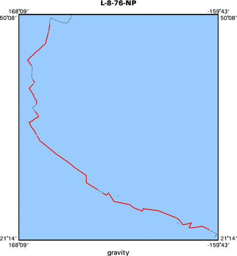
<http://walrus.wr.usgs.gov/infobank/l/l876np/html/l-8-76-np.grav.gif>
- Browse_Graphic_File_Description: Gravity data trackline map of L-8-76-NP
- Browse_Graphic_File_Type: GIF
- Browse_Graphic:
-
- Browse_Graphic_File_Name:
-
<http://walrus.wr.usgs.gov/infobank/l/l876np/html/l-8-76-np.mag.gif>
- Browse_Graphic_File_Description: Magnetics data trackline map of L-8-76-NP
- Browse_Graphic_File_Type: GIF
- Browse_Graphic:
-
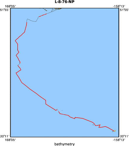
- Browse_Graphic_File_Name:
-
<http://walrus.wr.usgs.gov/infobank/l/l876np/html/l-8-76-np.bath.gif>
- Browse_Graphic_File_Description: Bathymetry data trackline map of L-8-76-NP
- Browse_Graphic_File_Type: GIF
- Browse_Graphic:
-
- Browse_Graphic_File_Name:
-
<http://walrus.wr.usgs.gov/infobank/l/l876np/html/l-8-76-np.samp.gif>
- Browse_Graphic_File_Description: Sampling locations map of L-8-76-NP
- Browse_Graphic_File_Type: GIF
- Data_Set_Credit:
-
Bob Duncan (Watchstander);
Brent Dalrymple (Chief Scientist);
Byron Ruppel (Geophysicist);
Carrie Carpenter (Dafe Curator);
Cece Roots (Watchstander);
Curtis Thompson (Chief Mate);
Dave Clague (Geologist);
Dick Doell (Navigator);
Elliot Sims (Watchstander);
Gary Greene (Geologist);
Harry Hill (Electronics Technician);
Jim Magill (Watchstander, MDB);
Karen Bachmann (Navigator);
Keith Bargar (Geologist);
Mark Brandon (Watchstander);
Pat McCrory (Watchstander);
Ralph Curtiss (Chief Engineer);
Ron Kistler (Geologist);
Steve Bright (Watchstander, MDB);
Sven Keinanen (Ship Captain)
- Native_Data_Set_Environment: Digital, ASCII
- Cross_Reference:
-
- Citation_Information:
-
- Originator: U.S. Geological Survey (USGS), Coastal and Marine Geology (CMG)
- Publication_Date: Unknown
- Title: USGS/CMG Information Bank
- Publication_Information:
-
- Publisher: U.S. Geological Survey (USGS), Coastal and Marine Geology (CMG)
- Other_Citation_Details: Updated daily
- Online_Linkage: <http://walrus.wr.usgs.gov/infobank/>
- Data_Quality_Information:
-
- Attribute_Accuracy:
-
- Attribute_Accuracy_Report: Identified as best available version.
- Logical_Consistency_Report: Unspecified
- Completeness_Report:
-
Start and end date/times of data
Navigation Data (l-8-76-np.011 [DRS])
YYYYMMDDHHMMSST    YYYYMMDDHHMMSST
197609290140000    197610070702000
197610070804000    197610070804000
197610070900000    197610072030000
197610072316000    197610080056000
197610080142000    197610080400000
197610080446000    197610080630000
197610080712000    197610090456000
197610090642000    197610100922000
197610101016000    197610111206000
197610111254000    197610121942000
197610160230000    197610160230000
197610160356000    197610160502000
197610160606000    197610170940000
197610171022000    197610200114000
197610200206000    197610200240000
197610200322000    197610200448000
197610200530000    197610201820000
197610201904000    197610201944000
197610202046000    197610210432000
197610210526000    197610210526000
YYYYMMDDHHMMSST    YYYYMMDDHHMMSST
Gravity Data (l-8-76-np.160_011)
YYYYMMDDHHMMSST    YYYYMMDDHHMMSST
197610040543300    197610040928300
197610041028300    197610052023300
197610060928300    197610061138300
197610061328300    197610061428300
197610061503300    197610070133300
197610070148300    197610070228300
197610070238300    197610070953300
197610071018300    197610071028300
197610072058300    197610080103300
197610080113300    197610081438300
197610081448300    197610082238300
197610090028300    197610090443300
197610090458300    197610090653300
197610090713300    197610120133300
197610120903300    197610121433300
197610121443300    197610121828300
197610160258300    197610171713300
197610172158300    197610200123300
197610200143300    197610201938300
YYYYMMDDHHMMSST    YYYYMMDDHHMMSST
Magnetics Data (l-8-76-np.240_011)
YYYYMMDDHHMMSST    YYYYMMDDHHMMSST
197609290140000    197609290527100
197609290548200    197609300959300
197609301045100    197609301200500
197610010041000    197610011435400
197610011525300    197610011934000
197610040500000    197610051725000
197610082345000    197610121440000
197610160255000    197610171430000
197610172200000    197610181750000
197610182115000    197610191810000
197610191825000    197610191830000
197610191845000    197610192300000
197610200035000    197610201130000
197610201140000    197610201530000
197610201630000    197610210430000
YYYYMMDDHHMMSST    YYYYMMDDHHMMSST
Bathymetry Data (l-8-76-np.335_011)
YYYYMMDDHHMMSST    YYYYMMDDHHMMSST
197609292205000    197609300045000
197609300130000    197609300145000
197609300151000    197609300550000
197609300655000    197609300955000
197610040535000    197610050904000
197610050910000    197610051805000
197610051815000    197610060135000
197610060143000    197610060434000
197610060440000    197610061144000
197610061150000    197610061603000
197610061610000    197610070950000
197610071800000    197610072319000
197610072325000    197610091425000
197610091440000    197610110414000
197610110420000    197610111125000
197610111131000    197610120649000
197610120655000    197610121428000
197610121435000    197610121644000
197610121650000    197610121720000
197610121735000    197610121830000
197610160630000    197610161435000
197610161455000    197610161529010
197610161535000    197610161620000
197610161655000    197610162238000
197610162255000    197610171708000
197610171715000    197610171754000
197610171800000    197610201640000
197610201647000    197610210525000
YYYYMMDDHHMMSST    YYYYMMDDHHMMSST
- Positional_Accuracy:
-
- Horizontal_Positional_Accuracy:
-
- Horizontal_Positional_Accuracy_Report: Unspecified
- Vertical_Positional_Accuracy:
-
- Vertical_Positional_Accuracy_Report: Unspecified
- Lineage:
-
- Process_Step:
-
- Process_Description:
-
Navigation Data
Converted to time format with year at start.

01/31/86 KAYE DUA0:[DATA.L876NP.N]L876NP.011;
DRB0:[DRS.REFMT]REFORMAT.EXE;5
- Process_Date: 20001030
- Process_Contact:
-
- Contact_Information:
-
- Contact_Organization_Primary:
-
- Contact_Organization: U.S. Geological Survey (USGS), Coastal and Marine Geology (CMG)
- Contact_Person: Clint Steele
- Contact_Position: Data Acquisition, Processing, and Storage (DAPS) Group Leader
- Contact_Address:
-
- Address_Type: mailing and physical address
- Address: USGS, MailStop 999, 345 Middlefield Road
- City: Menlo Park
- State_or_Province: CA
- Postal_Code: 94025-3561
- Country: USA
- Contact_Voice_Telephone: (650) 329-5055
- Contact_Facsimile_Telephone: (650) 329-5190
- Contact_Electronic_Mail_Address: csteele@usgs.gov
- Process_Step:
-
- Process_Description:
-
Gravity Data
10/31/1998  /tiger/l/l876np/grav/l-8-76-np.160_011
/bear/programs/edit/automerge/automerge

Input was...
Converted to time format with year at start.

02/04/86 BARB DUA0:[DATA.L876NP.G]L876NP.160;
DRB0:[DRS.REFMT]REFORMAT.EXE;5

Input was...
Converted to time format with year at start.

01/31/86 KAYE DUA0:[DATA.L876NP.N]L876NP.011;
DRB0:[DRS.REFMT]REFORMAT.EXE;5

time, lat, long, time(sec) to nearest nav fix, data values
- Process_Date: 19981031
- Process_Contact:
-
- Contact_Information:
-
- Contact_Organization_Primary:
-
- Contact_Organization: U.S. Geological Survey (USGS), Coastal and Marine Geology (CMG)
- Contact_Person: Clint Steele
- Contact_Position: Data Acquisition, Processing, and Storage (DAPS) Group Leader
- Contact_Address:
-
- Address_Type: mailing and physical address
- Address: USGS, MailStop 999, 345 Middlefield Road
- City: Menlo Park
- State_or_Province: CA
- Postal_Code: 94025-3561
- Country: USA
- Contact_Voice_Telephone: (650) 329-5055
- Contact_Facsimile_Telephone: (650) 329-5190
- Contact_Electronic_Mail_Address: csteele@usgs.gov
- Process_Step:
-
- Process_Description:
-
Magnetics Data
10/31/1998  /tiger/l/l876np/mag/l-8-76-np.240_011
/bear/programs/edit/automerge/automerge

Input was...
Converted to time format with year at start.

01/03/86 CAROLYN DRS$DATA:[L876NP.M]L876NP.240;
DRB0:[DRS.REFMT]REFORMAT.EXE;5
272/0500 to 275/1900 (20 sec data) from
     L876NP.200 from Barb
278/0500 to 295/0400 ( 5 min data) from
     L876NP._.MAGSX1 on TAM139
     L876NP200.DAT   on VAM139

Input was...
Converted to time format with year at start.

01/31/86 KAYE DUA0:[DATA.L876NP.N]L876NP.011;
DRB0:[DRS.REFMT]REFORMAT.EXE;5

time, lat, long, time(sec) to nearest nav fix, data values
- Process_Date: 20001102
- Process_Contact:
-
- Contact_Information:
-
- Contact_Organization_Primary:
-
- Contact_Organization: U.S. Geological Survey (USGS), Coastal and Marine Geology (CMG)
- Contact_Person: Clint Steele
- Contact_Position: Data Acquisition, Processing, and Storage (DAPS) Group Leader
- Contact_Address:
-
- Address_Type: mailing and physical address
- Address: USGS, MailStop 999, 345 Middlefield Road
- City: Menlo Park
- State_or_Province: CA
- Postal_Code: 94025-3561
- Country: USA
- Contact_Voice_Telephone: (650) 329-5055
- Contact_Facsimile_Telephone: (650) 329-5190
- Contact_Electronic_Mail_Address: csteele@usgs.gov
- Process_Step:
-
- Process_Description:
-
Bathymetry Data
10/31/1998  /tiger/l/l876np/bath/l-8-76-np.335_011
/bear/programs/edit/automerge/automerge

Input was...
Converted to time format with year at start.

05/20/86 BECKIE DUA0:[DATA.LEE76]TEST.335;
DUA0:[DATA.LEE76]TEMP.EXE;

02/11/86 BECKIE DISK$USERDISK:[BECKIE.TEMP]L876NP.335;
DRB0:[DRS.BAT]BATRED.EXE;1
This file was hand-digetized in 2-way traveltime(secs).
It was reduced using no Matthews correction and velocity
of sound assumed was 1500m/sec.

Input was...
Converted to time format with year at start.

01/31/86 KAYE DUA0:[DATA.L876NP.N]L876NP.011;
DRB0:[DRS.REFMT]REFORMAT.EXE;5

time, lat, long, time(sec) to nearest nav fix, data values
- Process_Date: 20001120
- Process_Contact:
-
- Contact_Information:
-
- Contact_Organization_Primary:
-
- Contact_Organization: U.S. Geological Survey (USGS), Coastal and Marine Geology (CMG)
- Contact_Person: Clint Steele
- Contact_Position: Data Acquisition, Processing, and Storage (DAPS) Group Leader
- Contact_Address:
-
- Address_Type: mailing and physical address
- Address: USGS, MailStop 999, 345 Middlefield Road
- City: Menlo Park
- State_or_Province: CA
- Postal_Code: 94025-3561
- Country: USA
- Contact_Voice_Telephone: (650) 329-5055
- Contact_Facsimile_Telephone: (650) 329-5190
- Contact_Electronic_Mail_Address: csteele@usgs.gov
- Spatial_Data_Organization_Information:
-
- Indirect_Spatial_Reference: Northern Pacific
- Direct_Spatial_Reference_Method: Point
- Point_and_Vector_Object_Information:
-
- SDTS_Terms_Description:
-
- SDTS_Point_and_Vector_Object_Type: Point
- Spatial_Reference_Information:
-
- Horizontal_Coordinate_System_Definition:
-
- Geographic:
-
- Latitude_Resolution: 0.00001
- Longitude_Resolution: 0.00001
- Geographic_Coordinate_Units: Decimal degrees
- Geodetic_Model:
-
- Horizontal_Datum_Name: North American Datum of 1927
- Ellipsoid_Name: Clarke 1866
- Semi-major_Axis: 6378206.4
- Denominator_of_Flattening_Ratio: 294.98
- Vertical_Coordinate_System_Definition:
-
- Depth_System_Definition:
-
- Depth_Datum_Name: Local surface
- Depth_Resolution: 0.1
- Depth_Distance_Units: meters
- Depth_Encoding_Method: Attribute values
- Entity_and_Attribute_Information:
-
- Overview_Description:
-
- Entity_and_Attribute_Overview: Bathymetry with Time Stamp
- Entity_and_Attribute_Detail_Citation:
-
Edited bathymetry data
Mnemonic:       (Year, Day, Hour, Min, Sec, Tenths, 2WayTravelTime, UncorrDepth)
FORTRAN format: (i4.4, i3.3, 3i2.2, i1.1, t16, f7.4, t23, f7.1)
C format:       (%4.4i%3.3i3%2.2i%1.1i %7.4f %7.1f\\n)
Naming:         .330
- Overview_Description:
-
- Entity_and_Attribute_Overview: Gravity with Time Stamp
- Entity_and_Attribute_Detail_Citation:
-
Free Air Anomaly data
Mnemonic:       (Year, Day, Hour, Min, Sec, Tenths, Eotvos, ObsGrv, TheoGrv, FAA)
FORTRAN format: (i4.4, i3.3, 3i2.2, i1.1, t16, f6.1, t23, f9.1, t33, f9.1, t43, f8.1)
C format:       (%4.4i%3.3i3%2.2i%1.1i %6.1f %9.1f %9.1f %8.1f\\n)
Naming:         .160
- Overview_Description:
-
- Entity_and_Attribute_Overview: Magnetics with Time Stamp
- Entity_and_Attribute_Detail_Citation:
-
Raw gradiometer data
Mnemonic:       (Year, Day, Hour, Min, Sec, Tenths, MstObs, SlvObs)
FORTRAN format: (i4.4, i3.3, 3i2.2, i1.1, t16, f7.1, t24, f7.1)
C format:       (%4.4i%3.3i3%2.2i%1.1i %7.1f %7.1f\\n)
Naming:         .240
- Overview_Description:
-
- Entity_and_Attribute_Overview: Navigation with Time Stamp
- Entity_and_Attribute_Detail_Citation:
-
Dead reckoning data
Mnemonic:       (Year, Day, Hour, Min, Sec, Tenths, Latitude, Longitude)
FORTRAN format: (i4.4, i3.3, 3i2.2, i1.1, t16, f9.5, t26, f10.5)
C format:       (%4.4i%3.3i3%2.2i%1.1i %9.5f %10.5f\\n)
Naming:         .010
- Distribution_Information:
-
- Distributor:
-
- Contact_Information:
-
- Contact_Organization_Primary:
-
- Contact_Organization: U.S. Geological Survey (USGS), Coastal and Marine Geology (CMG)
- Contact_Person: Clint Steele
- Contact_Position: Data Acquisition, Processing, and Storage (DAPS) Group Leader
- Contact_Address:
-
- Address_Type: mailing and physical address
- Address: USGS, MailStop 999, 345 Middlefield Road
- City: Menlo Park
- State_or_Province: CA
- Postal_Code: 94025-3561
- Country: USA
- Contact_Voice_Telephone: (650) 329-5055
- Contact_Facsimile_Telephone: (650) 329-5190
- Contact_Electronic_Mail_Address: csteele@usgs.gov
- Resource_Description: Downloadable Data L-8-76-NP data set
- Distribution_Liability:
-
Please recognize the U.S. Geological Survey (USGS) as
the source of this information.
Physical materials are under controlled on-site access.
Some USGS information accessed through this means
may be preliminary in nature and presented without
the approval of the Director of the USGS. This
information is provided with the understanding
that it is not guaranteed to be correct or complete
and conclusions drawn from such information are
the responsibility of the user.
This information is not intended for navigational
purposes.
Any use of trade, firm, or product names is for
descriptive purposes only and does not imply
endorsement by the U.S. Government.
- Standard_Order_Process:
-
- Digital_Form:
-
- Digital_Transfer_Information:
-
- Format_Name: ASCII
- File_Decompression_Technique: No compression applied
- Transfer_Size: 0.2
- Digital_Transfer_Option:
-
- Online_Option:
-
- Computer_Contact_Information:
-
- Network_Address:
-
- Network_Resource_Name:
-
<http://walrus.wr.usgs.gov/infobank/l/l876np/html/l-8-76-np.nav.html>
- Digital_Form:
-
- Digital_Transfer_Information:
-
- Format_Name: ASCII
- File_Decompression_Technique: No compression applied
- Transfer_Size: 0.3
- Digital_Transfer_Option:
-
- Online_Option:
-
- Computer_Contact_Information:
-
- Network_Address:
-
- Network_Resource_Name:
-
<http://walrus.wr.usgs.gov/infobank/l/l876np/html/l-8-76-np.grav.html>
- Digital_Form:
-
- Digital_Transfer_Information:
-
- Format_Name: ASCII
- File_Decompression_Technique: No compression applied
- Transfer_Size: 1.0
- Digital_Transfer_Option:
-
- Online_Option:
-
- Computer_Contact_Information:
-
- Network_Address:
-
- Network_Resource_Name:
-
<http://walrus.wr.usgs.gov/infobank/l/l876np/html/l-8-76-np.mag.html>
- Digital_Form:
-
- Digital_Transfer_Information:
-
- Format_Name: ASCII
- File_Decompression_Technique: No compression applied
- Transfer_Size: 0.2
- Digital_Transfer_Option:
-
- Online_Option:
-
- Computer_Contact_Information:
-
- Network_Address:
-
- Network_Resource_Name:
-
<http://walrus.wr.usgs.gov/infobank/l/l876np/html/l-8-76-np.bath.html>
- Fees: None
- Metadata_Reference_Information:
-
- Metadata_Date: 20081216
- Metadata_Contact:
-
- Contact_Information:
-
- Contact_Organization_Primary:
-
- Contact_Organization: U.S. Geological Survey (USGS), Coastal and Marine Geology (CMG)
- Contact_Person: Clint Steele
- Contact_Position: Data Acquisition, Processing, and Storage (DAPS) Group Leader
- Contact_Address:
-
- Address_Type: mailing and physical address
- Address: USGS, MailStop 999, 345 Middlefield Road
- City: Menlo Park
- State_or_Province: CA
- Postal_Code: 94025-3561
- Country: USA
- Contact_Voice_Telephone: (650) 329-5055
- Contact_Facsimile_Telephone: (650) 329-5190
- Contact_Electronic_Mail_Address: csteele@usgs.gov
- Metadata_Standard_Name: FGDC Content Standards for Digital Geospatial Metadata
- Metadata_Standard_Version: FGDC-STD-001-1998
- Metadata_Time_Convention: universal time
- Metadata_Access_Constraints: none
- Metadata_Use_Constraints: none
|


