Identification_Information:
Citation:
Citation_Information:
Originator: U.S. Geological Survey (USGS), Coastal and Marine Geology (CMG)
Publication_Date: 20081216
Title:
Sediment Sampling and Submersible Video data of field
activity S-1-07-PS in Skagit Delta, WA from 09/17/2007 to
09/22/2007
Publication_Information:
Publisher: U.S. Geological Survey (USGS), Coastal and Marine Geology (CMG)
Online_Linkage: http://walrus.wr.usgs.gov/infobank/gos/s-1-07-ps.fmeta.xml
Online_Linkage: http://walrus.wr.usgs.gov/infobank/s/s107ps/html/s-1-07-ps.meta.html
Description:
Abstract:
United States Geological Survey, Pacific Science
Center,Swinomish Indian Tribal Community, Water Resources
Program. Chief Scientists: Eric Grossman, Sarah Akin.
Sediment Sampling and Submersible Video data (submersible,
VanVeengrab) of field activity S-1-07-PS in Skagit Delta, WA
from 09/17/2007 to 09/22/2007,
http://walrus.wr.usgs.gov/infobank/s/s107ps/html/s-1-07-ps.meta.html.
Purpose:
These data and information are intended for science
researchers, students from elementary through
college, policy makers, and general public.
Supplemental_Information:
Equipment Used -
submersible video camera
VanVeengrab
Notes -
See related activity K-1-07-PS on line at:
http://walrus.wr.usgs.gov/infobank/k/k107ps/html/k-1-07-ps.meta.html
Similar information is available for thousands
of other USGS/CMG-related Activities.
If known, available are Activity-specific
navigation, gravity, magnetics, bathymetry,
seismic, and sampling data; track maps; and
equipment information; as well as summary
overviews, crew lists, and information
about analog materials.
If available, access to physical samples is
described in the "WR CMG Sample Distribution
Policy" at:
http://walrus.wr.usgs.gov/infobank/programs/html/main/sample-dist-policy.html
Primary access to the USGS/CMG Information
Bank's digital data, analog data, and
metadata is provided through...
http://walrus.wr.usgs.gov/infobank/
This page accomodates a variety of search
approaches (e.g., by platform, by region,
by scientist, by equipment type, etc.).
Time_Period_of_Content:
Time_Period_Information:
Range_of_Dates/Times:
Beginning_Date: 20070917
Ending_Date: 20070922
Currentness_Reference: ground condition
Status:
Progress: Complete
Maintenance_and_Update_Frequency: As needed
Spatial_Domain:
Bounding_Coordinates:
West_Bounding_Coordinate: -122.68065
East_Bounding_Coordinate: -122.41640
North_Bounding_Coordinate: 48.44181
South_Bounding_Coordinate: 48.26507
Keywords:
Theme:
Theme_Keyword_Thesaurus: ISO 19115 Topic Category
Theme_Keyword: geoscientificinformation
Theme_Keyword: oceans
Theme:
Theme_Keyword_Thesaurus: USGS CMG InfoBank
Theme_Keyword: Marine Geology
Place:
Place_Keyword_Thesaurus: USGS CMG InfoBank
Place_Keyword: North Pacific Ocean
Place_Keyword: Northern Pacific Ocean
Place_Keyword: Puget Sound
Place_Keyword: Puget Sound, WA
Place_Keyword: Skagit Delta, WA
Place_Keyword: USA
Place_Keyword: WA
Place_Keyword: Washington
Access_Constraints:
Physical materials are under controlled on-site access.
If available, access to physical samples is described
in the "WR CMG Sample Distribution Policy" at:
http://walrus.wr.usgs.gov/infobank/programs/html/main/sample-dist-policy.html
Use_Constraints:
Please recognize the U.S. Geological Survey (USGS) as
the source of this information.
Physical materials are under controlled on-site access.
Some USGS information accessed through this means
may be preliminary in nature and presented without
the approval of the Director of the USGS. This
information is provided with the understanding
that it is not guaranteed to be correct or complete
and conclusions drawn from such information are
the responsibility of the user.
This information is not intended for navigational
purposes.
Any use of trade, firm, or product names is for
descriptive purposes only and does not imply
endorsement by the U.S. Government.
Point_of_Contact:
Contact_Information:
Contact_Organization_Primary:
Contact_Organization: U.S. Geological Survey (USGS), Coastal and Marine Geology (CMG)
Contact_Person: Clint Steele
Contact_Position: Data Acquisition, Processing, and Storage (DAPS) Group Leader
Contact_Address:
Address_Type: mailing and physical address
Address: USGS, MailStop 999, 345 Middlefield Road
City: Menlo Park
State_or_Province: CA
Postal_Code: 94025-3561
Country: USA
Contact_Voice_Telephone: (650) 329-5055
Contact_Facsimile_Telephone: (650) 329-5190
Contact_Electronic_Mail_Address: csteele@usgs.gov
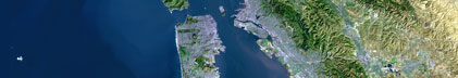
Browse_Graphic:
Browse_Graphic_File_Name: http://walrus.wr.usgs.gov/infobank/s/s107ps/html/s-1-07-ps.nav.gif
Browse_Graphic_File_Description: Trackline map of S-1-07-PS
Browse_Graphic_File_Type: GIF
Browse_Graphic:
Browse_Graphic_File_Name: http://walrus.wr.usgs.gov/infobank/s/s107ps/html/s-1-07-ps.samp.gif
Browse_Graphic_File_Description: Sampling locations map of S-1-07-PS
Browse_Graphic_File_Type: GIF
Data_Set_Credit:
Eric Grossman (Chief Scientist, USGS);
Sarah Akin (Co-Chief Scientist, Swinomish Tribal Community, Water Resources Program);
Eric Haskins (Information Specialist , Swinomish Tribal Community, Water Resources Program)
Native_Data_Set_Environment: Digital, ASCII
Cross_Reference:
Citation_Information:
Originator: U.S. Geological Survey (USGS), Coastal and Marine Geology (CMG)
Publication_Date: Unknown
Title: USGS/CMG Information Bank
Publication_Information:
Publisher: U.S. Geological Survey (USGS), Coastal and Marine Geology (CMG)
Other_Citation_Details: Updated daily
Online_Linkage: http://walrus.wr.usgs.gov/infobank/
Data_Quality_Information:
Attribute_Accuracy:
Attribute_Accuracy_Report: Identified as best available version.
Logical_Consistency_Report: Unspecified
Completeness_Report:
Start and end date/times of data
>Navigation Data (s-1-07-ps.060 [GPS])
>YYYYMMDDHHMMSST YYYYMMDDHHMMSST
>200709180252240 200709180555130
>200709190020000 200709190907140
>200709200234260 200709200723050
>200709210302530 200709210748090
>200709220047530 200709220512150
>200709220538010 200709220651350
>200709250202530 200709250601320
>YYYYMMDDHHMMSST YYYYMMDDHHMMSST
Positional_Accuracy:
Horizontal_Positional_Accuracy:
Horizontal_Positional_Accuracy_Report: Unspecified
Vertical_Positional_Accuracy:
Vertical_Positional_Accuracy_Report: Unspecified
Lineage:
Process_Step:
Process_Description:
Navigation Data
Unknown
Process_Date: 20071206
Process_Contact:
Contact_Information:
Contact_Organization_Primary:
Contact_Organization: U.S. Geological Survey (USGS), Coastal and Marine Geology (CMG)
Contact_Person: Clint Steele
Contact_Position: Data Acquisition, Processing, and Storage (DAPS) Group Leader
Contact_Address:
Address_Type: mailing and physical address
Address: USGS, MailStop 999, 345 Middlefield Road
City: Menlo Park
State_or_Province: CA
Postal_Code: 94025-3561
Country: USA
Contact_Voice_Telephone: (650) 329-5055
Contact_Facsimile_Telephone: (650) 329-5190
Contact_Electronic_Mail_Address: csteele@usgs.gov
Spatial_Data_Organization_Information:
Indirect_Spatial_Reference: Skagit Delta, WA
Direct_Spatial_Reference_Method: Point
Point_and_Vector_Object_Information:
SDTS_Terms_Description:
SDTS_Point_and_Vector_Object_Type: Point
Spatial_Reference_Information:
Horizontal_Coordinate_System_Definition:
Geographic:
Latitude_Resolution: 0.00001
Longitude_Resolution: 0.00001
Geographic_Coordinate_Units: Decimal degrees
Geodetic_Model:
Horizontal_Datum_Name: North American Datum of 1983
Ellipsoid_Name: Geodetic Reference System 80
Semi-major_Axis: 6378137
Denominator_of_Flattening_Ratio: 298.257
Vertical_Coordinate_System_Definition:
Depth_System_Definition:
Depth_Datum_Name: Local surface
Depth_Resolution: 0.1
Depth_Distance_Units: meters
Depth_Encoding_Method: Attribute values
Entity_and_Attribute_Information:
Overview_Description:
Entity_and_Attribute_Overview: Navigation with Time Stamp
Entity_and_Attribute_Detail_Citation:
Global positioning system (GPS) data
>Mnemonic: (Year, Day, Hour, Min, Sec, Tenths, Latitude, Longitude)
>FORTRAN format: (i4.4, i3.3, 3i2.2, i1.1, t16, f9.5, t26, f10.5)
>C format: (%4.4i%3.3i3%2.2i%1.1i %9.5f %10.5f\\n)
>Naming: .060
Distribution_Information:
Distributor:
Contact_Information:
Contact_Organization_Primary:
Contact_Organization: U.S. Geological Survey (USGS), Coastal and Marine Geology (CMG)
Contact_Person: Clint Steele
Contact_Position: Data Acquisition, Processing, and Storage (DAPS) Group Leader
Contact_Address:
Address_Type: mailing and physical address
Address: USGS, MailStop 999, 345 Middlefield Road
City: Menlo Park
State_or_Province: CA
Postal_Code: 94025-3561
Country: USA
Contact_Voice_Telephone: (650) 329-5055
Contact_Facsimile_Telephone: (650) 329-5190
Contact_Electronic_Mail_Address: csteele@usgs.gov
Resource_Description: Downloadable Data S-1-07-PS data set
Distribution_Liability:
Please recognize the U.S. Geological Survey (USGS) as
the source of this information.
Physical materials are under controlled on-site access.
Some USGS information accessed through this means
may be preliminary in nature and presented without
the approval of the Director of the USGS. This
information is provided with the understanding
that it is not guaranteed to be correct or complete
and conclusions drawn from such information are
the responsibility of the user.
This information is not intended for navigational
purposes.
Any use of trade, firm, or product names is for
descriptive purposes only and does not imply
endorsement by the U.S. Government.
Standard_Order_Process:
Digital_Form:
Digital_Transfer_Information:
Format_Name: ASCII
File_Decompression_Technique: No compression applied
Transfer_Size: 0.4
Digital_Transfer_Option:
Online_Option:
Computer_Contact_Information:
Network_Address:
Network_Resource_Name: http://walrus.wr.usgs.gov/infobank/s/s107ps/html/s-1-07-ps.nav.html
Fees: None
Metadata_Reference_Information:
Metadata_Date: 20081216
Metadata_Contact:
Contact_Information:
Contact_Organization_Primary:
Contact_Organization: U.S. Geological Survey (USGS), Coastal and Marine Geology (CMG)
Contact_Person: Clint Steele
Contact_Position: Data Acquisition, Processing, and Storage (DAPS) Group Leader
Contact_Address:
Address_Type: mailing and physical address
Address: USGS, MailStop 999, 345 Middlefield Road
City: Menlo Park
State_or_Province: CA
Postal_Code: 94025-3561
Country: USA
Contact_Voice_Telephone: (650) 329-5055
Contact_Facsimile_Telephone: (650) 329-5190
Contact_Electronic_Mail_Address: csteele@usgs.gov
Metadata_Standard_Name: FGDC Content Standards for Digital Geospatial Metadata
Metadata_Standard_Version: FGDC-STD-001-1998
Metadata_Time_Convention: universal time
Metadata_Access_Constraints: none
Metadata_Use_Constraints: none
|