
| The Library of Congress | |
|
|
|
Civil War Maps |
|
|
In a hurry? Save or print these Collection Connections as a single file.
Go directly to the collection, Civil War Maps, in American Memory, or view a Summary of Resources related to the collection.
Civil War Maps provides students an opportunity to study the history of the American Civil War era through cartographic data. The maps of this collection portray the overall course and specific battles of the war between North and South. They also portray the issues of territorial expansion, slavery, and secession, which surrounded the genesis of the conflict. In addition, students can use the maps to study railroads, naval battles, and the history of cartographic mapping in the U.S.
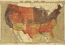
1) Territorial Expansion, Slavery, and Secession
As the United States expanded westward, the issue of whether or not new states would be admitted to the Union as slave states or free states was at the center of political debates. Finally, in 1861, the issues of slavery and state rights erupted into the American Civil War when southern states seceded from the Union and created the Confederacy.
Students can search on secession and slave to see maps depicting newly admitted states. Using visual data of where free and slave states were located, students can gain an understanding of why the country divided as it did. Did all the states that left the Union share borders? What similarities and common interests are implied by geographic proximity? Some similarities might include states' economies and agriculture. How do these relate to secession and war? Students can choose particular states and do research to find out if there was debate within the states on whether or not to secede.
Secession, 1860-1861, c1917.2) Protecting the Capitals
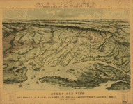
Panorama of the seat of war., c1861.Both Union and Confederate forces fought to protect their capitals from invasion. Washington, D.C., the capital of the United States, was situated dangerously close to enemy lines. The capital of the Confederacy in Richmond, Virginia was not too far south from Washington.
Students can search
on the names of the capitals. Based on the information in the maps, what bordered each capital? From which direction were the greatest threats likely to come? What forts were established to protect the capitals? This map includes both Washington, D.C. and Richmond, Virginia.Students can conduct additional research to determine how the war progressed and if these capitals remained out of the enemy's hands. Photographs of the capitals are online in the collection Civil War Photographs, 1861-1865 and can be retrieved by searching on Richmond and Washington DC.
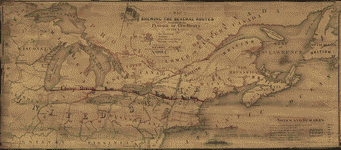
3) Railroads
The armies of the American Civil War made use of the railroad lines, a relatively new industrial development, transporting troops, ammunition, and other supplies. Because trains had set tracks and could only travel to certain destinations, railroads had a great impact on the course and outcome of the war. Students can search on railroad in Civil War Photographs, 1861-1865 to see images of trains used in the war. Some photographs show destroyed rail lines. Who might have destroyed these railroad lines and why? What was involved in repairing these lines, how long would it take, who repaired them, and how many people would be needed?
To learn more about railroad mapping and how the Civil War increased mapping of the rail lines, students can browse the collection Railroad Maps, 1828-1900 using the Title Index.
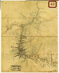
Map of United States military rail roads,... , 1866.Students can search the collection on railroad to see where rail lines traveled. They can determine which parts of the country were best served by the railroad at the time of the war. How might the location of railroad tracks have affected various military decisions?
4) The War at Sea
The use of ships for battle, blockade, and transport was a major factor in the course of the Civil War. For example, at the start of the war, President Lincoln issued a Proclamation of Blockade against Southern ports. Throughout the war this blockade limited the ability of the South to stay well-supplied in its war against the industrialized North. The Union also used ships along the Mississippi River to take New Orleans, the South's greatest seaport. On the Confederate side, in March of 1862, the Ironclad Merrimack sank two wooden Union ships, changing Naval warfare forever, as wooden ships were now obsolete.
Map shewing the several routes proposed for the passage of gunboats to the Lakes via: Erie and Oswego Canal; Champlain [Canal]; Illinois River and Chicago [Canal]; Wisconsin, Green Bay [Canal] , 1862.Students can search on ship, harbor, river, navy, nautical, or naval to find depictions of the Union blockade and locations of navy yards. Students can conduct further research on New Orleans and naval battles and then search the collection on the names of battle sites. Students can search on navy in Civil War Photographs, 1861-1865 to see images of the vessels used during the war.
- Where were the major naval battles of the Civil War? How were battles fought at sea? What types of ammunition were used?
- Did the Union blockade of the South cover the entire coast? If not, which ports were blockaded and why?
- From where was the South attempting to import supplies? Were they at all successful?
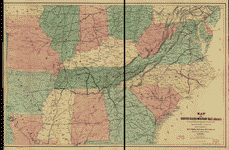
5) Mapping the Country
When war erupted in the United States in 1861, there were only outdated maps of many parts of the country, if any. One of the primary tasks of the Union and Confederate armies was to create a cartographic record. Students can discuss why maps were so important to the war effort.
Students can read the special presentation History of Mapping the Civil War for an excellent overview of the mapping capabilities and techniques of the North and South. Discuss with students how the rush to map the country might have effected the beginning of the war. How would a general prepare for battle if he did not know the lay of the land? How was the cartographic information gathered? What risks were the cartographers exposed to in creating the maps? How could inaccuracies in their maps change the course of the war?
Students can browse the collection's Title Index, looking at various mapping techniques. As seen in the maps below, there are visual clues as to which maps were made in haste and which had the benefit of time. Search on sketch and color to find additional maps.
Sketch of the road from Waynesboro toward Staunton, in Augusta County, Virginia, 1828-1899.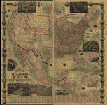
The new naval and military map of the United States, 1862.
| home | top of page |
| The Library of Congress | American Memory | Contact us |
| Last updated 09/26/2002 |