|
|
|
Metadata
|
|
ID
|
95011
|
|
Also Known As
|
95011
ASTR95011
A-11-95-LI
|
|
Abstract
|
United States Geological Survey, Woods Hole, Massachusetts.
Chief Scientists: Larry Poppe, Ralph Lewis. Data (navigation)
of field activity 95011 (A-11-95-LI) in Long Island Sound
Eastern Connecticut from 06/06/1995 to 06/12/1995
|
|
Organization
|
United States Geological Survey, Woods Hole, Massachusetts
|
|
Chief Scientist
|
Larry Poppe
Ralph Lewis
|
|
Platform
|
Asterias
|
|
Area of Operation
|
Long Island Sound Eastern Connecticut
|
|
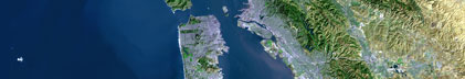
Location map
|

|
|
Bounding Coordinates
|
41.50000
-74.25000 -71.50000
40.50000
|
|
Dates
|
06/06/1995 (JD 157) to 06/12/1995 (JD 163)
|
|
Analog Materials
|
No analog holdings.
|
|
Index map

|
|
|
Crew
|
|
Larry Poppe
|
Chief Scientist, USGS Woods Hole
|
|
Dave Olmstead
|
captain, Asterias
|
|
Ralph Lewis
|
Chief Scientist, LISRC
|
|
M. Cohen
|
Unspecified
|
|
D. Toderlund
|
Unspecified, USCG
|
|
Ken Parolski
|
Physical Scientist, USGS Woods Hole
|
|
|
Equipment Used
|
|
|
Purpose
|
|
Side scan sonar, 3.5, bathy
|
|
|
Publications
|
|
Cruise Report exists at Woods Hole
|
|
|
Got Help?
|
For 95011, we would appreciate any information on -- activity type, analog materials, contract, days at sea, dive count, funding, information specialist, information to be derived, kms of navigation, national plan, NGDC Info, notes, owner, ports, project, project number, scanned materials, seismic description, station count, station description, submersible, summary, tabulated info.
|
|