|
|
|
Metadata
|
|
ID
|
97032
|
|
Also Known As
|
97032
DIAN97032
D-32-97-LI
|
|
Abstract
|
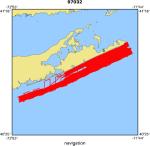
United States Geological Survey, Woods Hole, Massachusetts.
Chief Scientists: Bill Schwab, Rob Thieler. Data (navigation)
of field activity 97032 (D-32-97-LI) in New York Long Island
Shore from 09/24/1997 to 10/20/1997
|
|
Organization
|
United States Geological Survey, Woods Hole, Massachusetts
|
|
Chief Scientist
|
Bill Schwab
Rob Thieler
|
|
Platform
|
Diane G
|
|
Area of Operation
|
New York Long Island Shore
|
|
Location map
|
|
|
Bounding Coordinates
|
41.06773
-72.83686 -71.78975
40.65133
|
|
Dates
|
09/24/1997 (JD 267) to 10/20/1997 (JD 293)
|
|
Analog Materials
|
No analog holdings.
|
|
Index map

|
|
|
Crew
|
|
Bill Schwab
|
Chief Scientist, USGS Woods Hole
|
|
Rob Thieler
|
Chief Scientist, USGS Woods Hole
|
|
Bill Danforth
|
Unspecified, Leg 1, USGS Woods Hole
|
|
Chris Polloni
|
Unspecified, Leg 1, USGS Woods Hole
|
|
Dave Foster
|
Unspecified, Leg 1, USGS Woods Hole
|
|
Eric Haase
|
Unspecified, Leg 1, USGS Woods Hole
|
|
Tom O'Brien
|
Unspecified, Leg 1 and 2, USGS Woods Hole
|
|
Ann Swift
|
Unspecified, Leg 1 and 2, USGS Woods Hole
|
|
Ilya Buynevich
|
Unspecified, Leg 1, Boston Univ.
|
|
Brian Donahue
|
Unspecified, Leg 2, Univ. S. Fl
|
|
Jeff Lozier
|
Captain, Diane G
|
|
|
Equipment Used
|
|
|
Purpose
|
|
Side scan sonar-1000, geop, fathometer, grab, photo
|
|
|
Got Help?
|
For 97032, we would appreciate any information on -- activity type, analog materials, contract, days at sea, dive count, funding, information specialist, information to be derived, kms of navigation, national plan, NGDC Info, notes, owner, ports, project, project number, publications, scanned materials, seismic description, station count, station description, submersible, summary, tabulated info.
|
|


