|
|
|
Metadata
|
|
ID
|
01067
|
|
Also Known As
|
01067
N-1-01-MA
|
|
Abstract
|
Woods Hole Oceanographic Institution,United States
Geological Survey, Woods Hole, Massachusetts. Chief
Scientists: Bill Schwab, Peter Traykovski. Geophysical data
(SIS1000, GPS, sidescansonar) of field activity 01067
(N-1-01-MA) in Marthas Vineyard from 08/24/2001 to
08/31/2001
|
|
Organization
|
Woods Hole Oceanographic Institution
United States Geological Survey, Woods Hole, Massachusetts
|
|
Chief Scientist
|
Bill Schwab
Peter Traykovski
|
|
Activity Type
|
Geophysical
|
|
Platform
|
Nobska
|
|
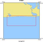
Area of Operation
|
Marthas Vineyard
|
|
Location map
|
|
|
Bounding Coordinates
|
41.35000
-70.67000 -70.48000
41.30000
|
|
Ports
|
leave Woods Hole, MA
arrive Woods Hole, MA
|
|
Dates
|
08/24/2001 (JD 236) to 08/31/2001 (JD 243)
|
|
Analog Materials
|
No analog holdings.
|
|
Index map

|
|
|
Information Specialist
|
|
|
Crew
|
|
Bill Schwab
|
Chief Scientist, USGS Woods Hole
|
|
Peter Traykovski
|
Chief Scientist, WHOI
|
|
Bill Danforth
|
Data Acquisition, USGS Woods Hole
|
|
Tom O'Brien
|
Electronics, USGS Woods Hole
|
|
Ilya Buynevich
|
PI, USGS Woods Hole and USGS Woods Hole Post Doc
|
|
Joe Newell
|
Mobilization, USGS Woods Hole
|
|
|
Equipment Used
|
|
SIS1000
|
|
GPS
|
|
sidescansonar
|
|
|
Purpose
|
|
Image ONR study site on south side of Martha's Vineyard.
|
|
|
Information to be Derived
|
|
All imagery and bathymetric data archived on DVD
|
|
|
Got Help?
|
For 01067, we would appreciate any information on -- analog materials, contract, days at sea, dive count, funding, kms of navigation, national plan, NGDC Info, notes, owner, project, project number, publications, scanned materials, seismic description, station count, station description, submersible, summary, tabulated info.
|
|


