Tending the Commons: Folklife and Landscape in Southern West Virginia

Interactive Maps

Big Coal River and Surrounding Area
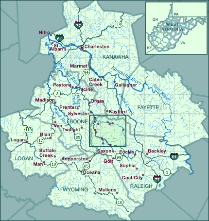
A map of the Big Coal River area in southern West Virginia.

Headwaters of the Big Coal River Nitro Nitro Charleston Charleston Charleston Charleston Charleston Charleston St. Alban's St. Alban's Marmet Marmet Marmet Cabin Creek Cabin Creek Cabin Creek Cabin Creek Cabin Creek Cabin Creek Cabin Creek Cabin Creek Gallagher Gallagher Gallagher Gallagher Gallagher Peytona Peytona Racine Racine Racine Orgas Orgas Orgas Kayford Kayford Madison Madison Madison Madison Madison Prenter Prenter Prenter Sylvester Sylvester Sylvester Van Van Twilight Twilight Twilight Twilight Blair Blair Blair Blair Blair Logan Logan Logan Logan Logan Beckley Eccles Eccles Eccles Eccles Saxon Saxon Saxon Buffalo Creek Buffalo Creek Buffalo Creek Buffalo Creek Buffalo Creek Buffalo Creek Man Man Kopperston Kopperston Kopperston Bolt Bolt Bolt Sophia Sophia Sophia Sophia Sophia Coal City Coal City Coal City Coal City Oceana Oceana Oceana Mullens Mullens Pond Fork Pond Fork Pond Fork Kanawha River Kanawha River Kanawha River New River New River New River Indian Creek Indian Creek Indian Creek

Map of Big Coal River and surrounding area information was compiled from the U.S. Geological Survey Geographic Names Information System (GNIS) Online Data Base portal for the U.S. Census Bureau's TIGER Mapping Service (Accessed April, 2000). Map information was modified for illustration purposes.

Map of West Virginia information was drawn from MapArt Geopolitical Deluxe CD-ROM by Cartesia Software (Copyright 1998). Map information was modified for illustration purposes.

 Top