|
 |
|
|
El-Niño/La-Niña
Comparison Photography |
 |
|
|
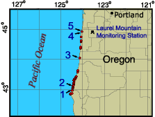
Locations:
1 |
2 |
3 |
4 |
5
|
|
|
|
|
|
|
|
|
 |
| |
Click on any
numbered location on the map above to view the photo set and data for that
location.
|
La-Niña Mapping, May, 1999
A Follow-on Experiment to the El-Niño Coastal Mapping,
October 1997 / April 1998
In the fall of 1997 and the spring of 1998, a USGS-NASA-NOAA
consortium successfully mapped 1200 km of the Pacific Coast to
document coastal effects from the El-Niño storm conditions. (See
lidar and aerial photography web sites). A small follow-on
experiment was attempted in the spring of 1999 to document
coastal changes by photography the year after the El-Niño storm
season. Aerial photography is used as a reconaissance tool to see
how often repeat mapping missions are required. Sea surface
temperatures were abnormally cool in the spring of 1999 indicative
of La-Niña conditions. In addition considerable snowpack
remained on the peaks of the Cascades and Sierra Nevada
mountain ranges at the time of the overflights, so additional
coastal effects may have occurred after the photography was
acquired.
|
|
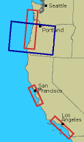
Map of west
coast El-Niño photography areas, indicated by red
boxes. Area of above follow-on map of Oregon is indicated by the
blue box. |
A hypothesis was developed after the El-Niño missions based on
the sedimentation patterns observed at the river mouths (Edgar and
Krohn, 1998). The hypothesis states that precipitation seasonality
is a major factor influencing sedimentation. In the 1997/1998 El-Niño storm season, the largest difference between low and high
precipitation occurs in Central California, which also shows some
of the largest sedimentation effects.
A sample of the La-Niña sedimentation patterns for southern
Oregon can be observed here. The site showing some of the
largest changes during the El-Niño missions
(site 1) shows little
change for La-Niña conditions. Some streams show a remigration
to pre El-Niño conditions (site 2). The configuration of streams in
the area blanked in 1998 by coastal fog seem to remain fairly
constant as well (site 3). The one exception to this pattern of little
change seems to be around the Siletz River
(sites 4 and 5). A large
amount of sedimentation occurs in the La-Niña conditions that
were not observed pre or post El-Niño. While the cause of this
sedimentation is unknown at this time, an extreme amount of
rainfall was recorded in May, 1999 at the Laurel Mountain rain
gauging station (Fig 1).
Photo acquisitions were attempted for the central and southern
California coasts to complement this data set, but coastal fog from
the La-Niña conditions prevented acquisition of more aerial
photography.
|