|
 |
|
|
| 1997-98 El-Niño Oblique Aerial Photography Home |
 |
|
|
 |
| Aerial Photography Location Indexes |
|
|
|
|
|
|
|
|
|
|
 |
|
|
|
|
|
|
|
|
|
| |

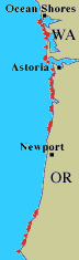
West Coast Aerial Photography Coverage: Click on any of the three
boxed coastline areas on the map above to view the aerial photography
index for that area. |
The U.S. Geological Survey as part of its Coastal and Marine Program is taking
aerial photographs to assess coastal erosion from severe storms.
Our mission is to acquire precision-located oblique still and video
photography before and after storm events to document storm-related
changes to the coastline.
USGS acquired baseline coverage
of over 1000 km of coastline from the west coast of the US in October,
1997, in anticipation of storms generated by the El-Niño warming of
the Pacific Ocean. Three areas of the Pacific Coast were targeted:
- Southern Washington/Northern Oregon
- Central California
- Southern California
WA / OR
 |
Central CA
 |
Southern CA
 |
|
| Aerial Photography Locations:
Fifty individual airphoto pair locations are denoted by red triangles on
each of the above maps. Click on the shoreline to view the airphoto index for
that section of the coast. |
A follow-up mission was completed in April,
1998 after the storm season.
One hundred aerial photographs - 50 matched pairs - are available from the
each of the three areas of the coast showing examples of different types of coastal
changes occurring during the 97/98 winter. The photographs were taken
from a NOAA Twin Otter aircraft flying at 500 feet and 130 knots.
The photos in each area can be accessed by an index map or an location index.
|