

Use these links to access detailed analyses of Global and U.S. data. 
|
|
Seasonal Overview / Influencing Factors / Impacts of 2004 season Overview The Atlantic Basin had a more active season than average in 2004 with 15 tropical storms and 9 hurricanes, including 6 major hurricanes. The average (based on data from 1944-1996) is approximately 10 named storms and 6 hurricanes, including 2-3 major hurricanes. The ACE index of hurricane activity also indicates an above average season, with a preliminary value of approximately 220 x104 knots. An average season is anywhere from 66 x104 knots to 103 x104 knots. Hurricane Ivan alone produced an ACE value of 69.9 x10⁴ knots. Its strength and longevity contributed substantially to the cumulative seasonal activity and it holds the record for the greatest consecutive time (7 days) spent with windspeeds of 120 kts/138 mph or greater for any basin. After weakening back to a depression, Ivan also looped southward and then westward through the Atlantic to regenerate into a tropical storm in the Gulf of Mexico. The first named storm of the season, Alex, brushed North Carolina in August before moving northeast and reaching windspeeds of 105 kts (121 mph), category 3 on the Saffir-Simpson scale. The only other storm to reach major hurricane status north of 38N was Hurricane Ellen in 1973 and it reached 100 kts (115 mph). This season is also the most costly hurricane season on record ($42 billion) for the US, with 9 storms affecting its coast. Impacts are described below. Of additional interest was the development, in March, of a hurricane in the South Atlantic, the only documented hurricane in that basin to impact land, and the first hurricane in the South Atlantic to be recorded in the satellite era. Influencing Factors: The official NOAA forecast for this season was for 12-15 named storms, with 6-8 becoming hurricanes and 2-4 major hurricanes. This forecast was based on several different factors: The likely continuation of a multi-decadal cycle that has been in an active phase since 1995, warmer than normal sea surface temperatures (SSTs), and a neutral ENSO phase. Tropical cyclone activity in the Atlantic has been above normal since 1995 in response to the active phase of the multi-decadal signal. The average number of tropical storms since 1995 has been 13, compared to 8.6 during the preceding 25 years during which time the multi-decadal signal was in an inactive phase. An average of 7.7 hurricanes and 3.6 major hurricanes since 1995 compares to 5 hurricanes and 1.5 major hurricanes from 1970-1994. Features of an active multi-decadal signal in the Atlantic include warmer SSTs in the tropical Atlantic, an amplified sub-tropical ridge at upper levels across the central and eastern North Atlantic, and reduced vertical wind shear in the deep tropics over the central North Atlantic. The African Easterly Jet (AEJ) also needs to be favorable for promoting hurricane development from tropical disturbances moving westward off the coast of Africa. The existence of an El Niño or La Niña also significantly impacts the seasonal tropical cyclone activity in the Alantic. Generally, an El Niño in the tropical Pacific will limit activity in the Atlantic and vice versa for a La Niña. Despite the existence of a weak El Nino beginning in August 2004, the lack of a (Pacific) basin-wide structure to the El Niño led to the delayed onset of Atlantic teleconnections, permitting the above average activity to continue through the season. Of primary importance in this Atlantic hurricane season then, was the continuation of the active phase of the Altantic multi-decadal signal, including above average SSTs. Impacts of 2004 Season: Nine tropical systems affected the US during 2004. The estimated cost of damage to the US from hurricanes and tropical storms in 2004 is over $42 billion. This is the most costly hurricane season ever for the US, with the second most costly, at $35 billion, being 1992, the year that Hurricane Andrew impacted Florida. Five hurricanes made landfall in the US with Hurricane Alex also impacting North Carolina without officially making landfall. The record number of landfalling hurricanes in a season is 6 and this occurred in both 1916 and 1985. 2004 shares second place with 1933. An unprecented 4 hurricanes (Charley, Frances, Ivan and Jeanne) affected Florida this year, indeed no other state has been affected by four hurricanes in one season since Texas in 1886. An estimated one in five homes in Florida were damaged by hurricanes during August and September 2004 and 117 people lost their lives in the state from the storms. The first hurricane officially to make landfall in the US in 2004, Hurricane Charley, was the strongest and costliest storm to hit the US since Andrew in 1992. Charley was a category 4 storm when it made landfall in Florida and caused approximately $14 billion in damage. The hurricane made a second landfall along the South Carolina coast at category one strength. Hurricane Gaston (reclassified as a hurricane in post-storm analysis) made landfall within a few miles of Charley in South Carolina and within less than three weeks. 2004 is the first year since 1959 that two named storms have come ashore along the South Carolina coast in one season. Hurricane Frances made landfall in Florida as a category 2 hurricane in early September and caused over $8 billion in damage. Widespread rainfall amounts over 6 inches and extensive flooding occurred as Frances moved northward through the Appalachian Mountains. This flooding was compounded by the remnants of Ivan less than 2 weeks later. Ivan made landfall as a category 3 storm near Gulf Shores Alabama on September 16th. Overall, Ivan caused $13 billion in damage. Approximately 3 weeks after Hurricane Frances came ashore near Sewall's Point, Florida, Hurricane Jeanne made landfall at almost the exact same location. This is the first known occurrence of two hurricanes making landfall so close in space and time. Jeanne was a category 3 storm at the point of landfall and led to over $6 billion in damages in the U.S. However, the main impact of Jeanne was in Haiti where over 3,000 people were killed due to flooding from Jeanne's torrential rainfall. More information on these storms and all others this Atlantic hurricane season can be found in the monthly summaries below. |
 larger image |
Late November Storm: Tropical Storm Otto formed late in November on the 30th, about 800 miles east of Bermuda. November 30th is the last official day of the hurricane season. Otto moved southeastward over the two days and slowly weakened to a depression on December 2nd about 880 miles east-southeast of Bermuda. |
 October
|
Two named storms formed in October, with Hurricane Lisa continuing into October and dissipating over the North Atlantic early in the month.
Lisa, which developed in September, was a tropical storm at the beginning of October and strengthened on October 2nd, briefly becoming a hurricane before weakening again later that afternoon due to increased wind shear and cooler waters. Lisa became an extratropical storm on October 3rd and was then absorbed by a larger extratropical low pressure system about 300 miles north-northwest of the northern Azores. |
 larger image |
Tropical Storm Matthew formed from a tropical wave in the southwestern Gulf of Mexico on October 6th. Over the next couple of days Matthew maintained tropical storm strength while moving north-northeast and then northeast and finally north to come ashore across central Louisiana on October 10th. As much as 10 inches of rain fell as a result of the storm over parts of Louisiana, before the storm dissipated over Arkansas on the 11th.
|
| Sub-Tropical Storm Nicole formed on the 10th near Bermuda from an extratropical low pressure system. Nicole moved northward, then northeastward and encountered a strong upper level trough that steered the storm rapidly to the northeast. Late on the 11th, Nicole was absorbed by a large extratropical low pressure system about 345 miles south-southwest of Halifax, Nova Scotia. |
| A table containing the Accumulated Cyclone Energy (ACE) index for global tropical cyclones, occurring during the month of October 2004 is available |
September| Four named storms formed in September, with an additional storm (Frances) that formed in August and made landfall in September in Florida. |
 larger image |
Details on the early stages of Frances can be found in the August section.
Hurricane Frances was at category four strength (140 mph, 122 kts) as it moved towards the southeastern Bahamas, passing over the Turks and Caicos Islands on September 1st. The hurricane moved west-northwest across the central Bahamas over the next several days gradually diminishing in forward speed and fluctuating in intensity. By the afternoon of September 4th, Frances had stalled about 50 miles off the coast of Palm Beach Florida with windspeeds of 105 mph (91 kts).
|
| The eye finally made landfall in the U.S. early on the 5th near Sewall's Point, Florida with maximum sustained winds of 105 mph (91 kts), however, hurricane force winds had battered the coast for several hours before the eye came ashore. The storm weakened as it continued to move west-northwest across the Florida Peninsula and re-emerged over the Gulf of Mexico before making a second landfall on the 6th near St Mark's, Florida with windspeeds of 65 mph (56 kts). As Frances weakened to a tropical depression late on the 6th as it moved over Georgia, extensive flooding resulted from the storm. Over 15 inches (381mm) of rain fell in some locations as Frances moved up the Appalachian range and into the Northeast over the next several days. Locations from Georgia to New York suffered flood damage. For more details on the impacts of Frances, go to NCDC's Hazards page |
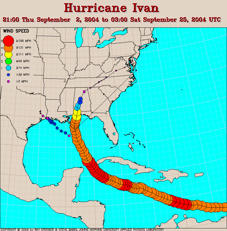
| A ninth seasonal tropical depression was identified on September 2nd in the eastern tropical Atlantic. This developed into Tropical Storm Ivan on September 3rd. Ivan moved toward the west at about 9 degrees North and became a hurricane on September 5th. Later that same day, Ivan reached category 4 strength on the Saffir-Simpson scale, a major hurricane. |
| Ivan moved over Grenada on September 7th destroying much of the property there and strengthened to become a
category 5 storm early on September 9th. Some fluctuations in intensity occurred with Ivan over the following several days and the eye tracked just offshore of southwest Jamaica on the 11th with windspeeds of 150 mph (130 kts), category 4. As the storm passed the Cayman Islands at category 5 strength on September 11th, considerable damage was again inflicted. Ivan remained at category 5 strength until September 12th when it weakened again to category 4, regaining category 5 intensity on the 13th.
|
 larger image |
 larger image |
Hurricane Ivan passed the western tip of Cuba on the 13th and spent the next three days moving northwestward in the Gulf of Mexico, slowly weakening. Early on September 16th, Ivan made landfall as a category 3 storm near Gulf Shores, Alabama. The storm moved slowly northeastward across the southeastern US after landfall and weakened to an extratropical low as it moved offshore around the Delmarva Peninsula on the 19th. The remnants of Ivan continued to make a loop moving southwestward, then westward and crossing Florida into the Gulf of Mexico on September 21st. Ivan regained strength to reach tropical storm intensity, then made a second landfall over the extreme southwestern tip of Louisiana on the 24th. The storm dissipated over eastern Texas later the same day. |
| Damage from Ivan was severe in the southeastern US with widespread flooding. Selected rainfall totals from Ivan are available here. And more information on the impacts of the storm can be found on NCDC's Global Hazards page. |
| The tenth named tropical system of the Atlantic basin began as a tropical wave that developed into a tropical depression on September 13th just east of the Leeward Islands. Tropical Storm Jeanne formed on the 14th from that depression, as it moved north-northwest across the Leeward Islands. Over the next several days Jeanne moved west-northwest dumping huge amounts of rain over Puerto Rico, Haiti and the Dominican Republic. The storm briefly reached hurricane strength before weakening slightly while interacting with the high terrain of Hispaniola. |
| Jeanne then tracked northward on the 18th and became a hurricane on the 20th, reaching category two strength while making a clockwise loop in the western Atlantic. The hurricane began tracking westward on the 23rd, reaching Abaco Island and Grand Bahama Island in the northwestern Bahamas on the 25th, while at category 3 strength. Jeanne continued westward and made landfall at Stuart, Florida near midnight on the 26th with windspeeds of 120 mph (105 kts), category 3. The location of Jeanne's landfall was almost exactly the same as Hurricane Frances only 20 days earlier. The storm moved northwestward, then northward through Florida, weakening to a tropical storm and then tracked across Georgia and the Carolinas accompanied by heavy rain, finally exiting the coast, just east of New Jersey on the 29th. |
 larger image |
| Flooding caused by the rainfall from Jeanne was responsible for over 3000 deaths in Haiti. More details on Jeanne's impacts are available on NCDC's Global Hazards page. |
 larger image |
Fluctuating in intensity Karl turned northward, then northeastward over the next couple of days. Eventually, Karl lost tropical characteristics on the 24th, approximately 935 miles northwest of the Azores. Tropical Storm Lisa began life as a tropical depression on the 19th of September approximately 645 miles west-southwest of the Cape Verde Islands. Lisa became a tropical storm the next day as it moved westward, and then eventually turned northward on the 24th. Windspeeds in Tropical Storm Lisa intensified to 70 mph (61 kts) on September 30th as the storm moved slowly northward. Hurricane strength was briefly reached on October 1st for Lisa, though the storm began to weaken the next day in the far North Atlantic becoming extratropical about 475 miles north-northwest of the Azores. |
August|
Hurricane Alex developed off the North Carolina coast from a tropical depression that had formed at the end of July approximately 175 miles south-southeast of Charleston, South Carolina. Alex quickly and unexpectedly intensified to a category 2 storm with sustained winds close to 100 mph (85 kts) on August 3rd. The outer wall of the eye brushed the Outer Banks of North Carolina at Cape Hatteras, but the storm did not officially make landfall. The strongest winds remained offshore, although sustained category one wind-speeds were recorded on the Outer Banks. Alex continued to strengthen as it moved northward and is the strongest Atlantic tropical storm on record north of 38° North, with maximum sustained winds at 120 mph (105 kts).
|
 larger image |
 larger image |
Tropical Storm Bonnie came ashore on August 12th in Florida's Panhandle with maximum sustained winds of around 50 mph (43 kts). Bonnie formed in the southern Gulf of Mexico on August 9th from the remnants of a tropical depression, which had degenerated into a tropical wave as it crossed the Caribbean Sea, but then re-intensified. Bonnie moved to the northwest and then north and reached maximum sustained winds of 65 mph (56 kts) on August 11th. |
| Hurricane Charley began as a tropical depression that formed just north of Trinidad and Tobago on August 9th. Slowly strengthening and moving west-northwest across the Caribbean Sea, Charley reached hurricane strength on August 11th, just south of Jamaica as it turned to a more northerly track. |
| The hurricane intensified rapidly before becoming a powerful category four storm with estimated surface winds of 145 mph (126 kts). Charley made landfall along the west coast of Florida just north of Fort Myers at Cayo Costa on Friday 13th. A wind gust of 111 mph (97 kts) was measured at the Punta Gorda Airport before the instrument failed. Damage from the storm was extensive and costs will likely total well over 10 billion dollars. At least 16 people were killed as Charley moved across Florida and over 2 million customers lost power. Charley maintained hurricane strength as it moved across the Florida Peninsula though windspeeds dropped to approximately 86 mph (75 kts, category one) as it reached the east coast of the state and re-emerged over Atlantic waters. |
 larger image |
|
As the hurricane moved north-northeast and made a second landfall along the South Carolina coast around McClellanville (between Charleston and Georgetown, SC), sustained winds were still category one hurricane strength. Charley quickly weakened after landfall, but maintained tropical storm force winds as far north as coastal New England. Charley dissipated on August 15th as it moved across Massachusetts and towards the Canadian Maritimes. Rainfall along the east coast totaled 1-3 inches (25-75 mm) in many locations, but Charley's rapid forward movement ensured that rain totals were less than if it had been moving slowly.
For more information on Charley's impacts, please go to NCDC's hazards page. Danielle was a strong category two hurricane at its peak intensity, but never affected land. It developed as a tropical storm on August 13th just south of the Cape Verde Islands in the far eastern Atlantic and tracked west-northwestward. Danielle became a hurricane on the 14th reaching a maximum sustained wind of 105 mph (91 kts). It dissipated on the 21st about 855 miles west-southwest of the Azores. |
|
Earl became a tropical storm on August 14th in the central tropical Atlantic, but was short-lived. As Earl moved westward and crossed the Windward Islands on the 15th, sustained winds were 45 mph (39 kts) with heavy rains. However, the next day as Earl moved into the eastern Caribbean, it degenerated to a tropical wave. A tropical depression in the eastern Atlantic that was later to become Hurricane Frances developed on August 24th and became a tropical storm the next day as it moved northwestward. Strengthening to a hurricane on the 26th while in the central Atlantic, Frances then turned westward and continued to intensify. |
 larger image |
|
At the end of August, Hurricane Frances was a 140 mph (kts) storm (category 4) and was located 125 miles north of Puerto Rico. Further details on Frances can be found in the September report. |
 larger image |
Gaston began as a tropical depression on August 27th about 140 miles southeast of Charleston, South Carolina, becoming a tropical storm the following day. Gaston moved toward the coast as it strengthened and made landfall near McClellanville, South Carolina on August 29th with maximum sustained winds at 70 mph (61 kts). The storm quickly weakened to a tropical depression and Gaston's main impact was flooding as it drenched parts of North Carolina and Virginia during its northeastward passage over land. Downtown Richmond, Virginia suffered severe flooding from the rainfall associated with Gaston. The storm re-emerged over water, east of Delaware, and regained tropical storm strength. It then traveled northeastward and weakened as it moved past Nova Scotia. |
|
Tropical Storm Hermine formed on August 29th approximately 350 miles west of Bermuda and moved northward while winds increased in speed to 50 mph (43 kts). However, Hermine weakened thereafter becoming extratropical on August 31st as it crossed eastern Massachusetts with sustained winds of 35 mph (30 kts). |
July|
The first tropical system of the Atlantic season formed approximately 175 miles south-southeast of Charleston, South Carolina on July 31st. Tropical Depression One was initially poorly organized and did not show signs of significant intensification. However, the storm became Hurricane Alex during the first few days of August and more details can be found in the August section.
|
 larger image |
| A table containing the Accumulated Cyclone Energy (ACE) index for global tropical cyclones, occurring during the month of July 2004 is available |
June|
No tropical storms or hurricanes developed in June 2004. This is not unusual, with 50% of all Junes in the long-term record registering no tropical activity. Sea surface temperatures (SSTs) were near average across the tropical Atlantic, though above average in a broad band across the North Atlantic from Spain to Florida. Climatologically, if tropical activity occurs in June, it is most likely in the western Caribbean, Gulf of Mexico or far western Atlantic along the U.S. east coast.
|
 larger image |
Pre-Season|
The official Atlantic hurricane season runs from June 1st to November 30th each year. Though tropical systems can form at any time of the year in the tropical Atlantic, they are comparatively rare outside of the official season. In March 2004 a hurricane developed in the South Atlantic. This was the first recorded hurricane in the South Atlantic basin since geostationary satellite records began in 1966. This storm came ashore along the coast of Brazil at Santa Catarina on March 28th with sustained winds of 65-70 kts (75-80 mph) and gusts of 85 kts (95 mph). At least 3 people died and 38 were reported injured as a result of the storm. Hurricanes typically do not form south of the equator in the Atlantic due to higher windspeeds aloft, generally preventing the storms from gaining height and therefore strength. However, little is known about why they occasionally do form. Satellite imagery of the storm will allow researchers to study 'Hurricane Caterina' further. |
 larger image |
As the graph to the left indicates, the long-term average number of storms for the tropical Atlantic is nearly 10 per year with almost 6 of those becoming hurricanes and 2-3 of those developing into major hurricanes (category 3 or higher on the Saffir-Simpson scale). However, there has been a generally more active period since 1995 with a seasonal average (based on data between 1995 and 2003) of 13 tropical storms, 7.6 hurricanes and 3.6 major hurricanes. September is generally the most active time of the year for the Atlantic, but this does not preclude large or destructive storms occurring at any time during the season. Early season storms (those occurring in June) have a greater likelihood of developing in the Gulf of Mexico than in the rest of the tropical Atlantic.
|
| The official NOAA forecast for 2004 is for an above average season based on both the expected number of tropical storms and an index developed to take into account total activity (ie., intensity and duration of total storms) termed the Accumulated Cyclone Energy (ACE) index. The most recent (May) forecast indicates that there will be 12-15 tropical storms with 6-8 hurricanes and 2-4 of those becoming major hurricanes. |
Useful Links
|
Questions?| For all climate questions other than questions concerning this report, please contact the National Climatic Data Center's Climate Services Division: |
|
Climate Services Division NOAA/National Climatic Data Center 151 Patton Avenue Asheville, NC 28801-5001 fax: 828-271-4876 phone: 828-271-4800 email: questions@ncdc.noaa.gov |
|
For further information on the historical climate perspective presented in this report, contact: |
|
David Levinson NOAA/National Climatic Data Center 151 Patton Avenue Asheville, NC 28801-5001 fax: 828-271-4328 email: David.Levinson@noaa.gov |
 NCDC / Climate Monitoring / Climate of 2004 / hurricanes / Search / Help


