|
|
|
Metadata
|
|
ID
|
I-1-99-SF
|
|
Abstract
|
United States Geological Survey, Woods Hole, Massachusetts.
Chief Scientists: Uri ten Brink, Neal Driscoll. Seismic data
(GPS, Chirp) of field activity I-1-99-SF in Offshore Ocean
Beach to Golden Gate, San Francisco, CA from 08/15/1999 to
08/15/1999
|
|
Organization
|
United States Geological Survey, Woods Hole, Massachusetts
|
|
Chief Scientist
|
Uri ten Brink
Neal Driscoll
|
|
Activity Type
|
Seismic
|
|
Platform
|
Ironic
|
|
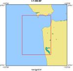
Area of Operation
|
Offshore Ocean Beach to Golden Gate, San Francisco, CA
|
|
Location map
|
|
|
Bounding Coordinates
|
37.82270
-122.58773 -122.48235
37.70762
|
|
Dates
|
08/15/1999 (JD 227) to 08/15/1999 (JD 227)
|
|
Analog Materials
|
No analog holdings.
|
|
Index map

|
|
|
Information Specialist
|
|
|
Crew
|
|
Uri ten Brink
|
Chief Scientist, USGS Eastern Region
|
|
Neal Driscoll
|
Chief Scientist
|
|
Bob Goodman
|
Captain
|
|
Ken Bates
|
Owner
|
|
|
Equipment Used
|
|
|
Purpose
|
|
Obtain high-resolution seismic across San Andreas Fault.
|
|
|
Information to be Derived
|
|
Mapping San Andreas fault strands in detail.
|
|
|
Notes
|
|
Imaging of 3-km-wide deformation zone showing tightly folded anticlines
|
|
|
Got Help?
|
For I-1-99-SF, we would appreciate any information on -- analog materials, contract, days at sea, dive count, funding, kms of navigation, national plan, NGDC Info, owner, ports, project, project number, publications, scanned materials, seismic description, station count, station description, submersible, summary, tabulated info.
|
|


