|
! Converted to time format with year at start.
|
|
!
|
|
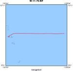
DATA COLLECTION OVERVIEW (use NGDC GEODAS CD to retrieve data)
|
|
|
|
MCG Data Collection ID --- W1175NP
|
|
Institution Data Collection ID --- ERDC11WT
|
|
NGDC ID --- 15040019
|
|
Funding --- (unspecified)
|
|
Project, Cruise & Leg --- EURYDICE LEG 11
|
|
Study region --- +33.00000, +0.00000,+171.00000,-111.00000
|
|
Chief Scientist(s) --- WINTERER E.L.
|
|
Name of vessel --- R/V THOMAS WASHINGTON (surface ship)
|
|
Date field data collection started --- 06/20/75 MAJURO
|
|
Date field data collection ended --- 07/18/75 SAN DIEGO
|
|
Parameters surveyed ---
|
|
Bathymetry: surveyed, contained in data file
|
|
Magnetics: surveyed, contained in data file
|
|
Gravity: surveyed, but not contained in data file
|
|
High-resolution seismics: surveyed, but not contained in data file
|
|
Deep penetration seismics: surveyed, but not contained in data file
|
|
Format --- (I1,A8,F5.2,4I2,F5.3,F8.5,F9.5,I1,F6.4,F6.1,I2,i1,3F6.1,I1,F5.1,F6.0,F7.1,F6.1,F5.1,A8,4I1)
|
|
Date of data input to NGDC --- 10/30/79
|
|
Contributing institution --- SCRIPPS INSTITUTION OF OCEANOGRAPHY
|
|
Country --- USA
|
|
|
|
Navigation instrumentation --- SATNAV,AUTOLOG GYRO + EMLOG
|
|
Position determination method --- LINEAR INTERP.BETWEEN ADJACENT FIXES
|
|
|
|
Bathymetry instrumentation --- 3.5-12KHZ/UGR,GIFFT RECORDERS/WIDEBEAM
|
|
Additional forms of bathymetric data --- ANAL.RECORDS,CARDS,35MMFILM(3.5KHZ)
|
|
General rate of bathymetry in file --- 5.0 minutes
|
|
General collection rate of bathymetry --- 1SECONDSWEEP
|
|
Assumed sound velocity --- 1463.0 m/sec
|
|
Bathymetric datum code --- No correction applied (sea level)
|
|
Bathmetry interpolation scheme --- 5 MINUTE INTERVAL
|
|
|
|
Magnetics instrumentation --- VARIAN MFD PROTON PRECESSION MOD 4970
|
|
Additional forms of magnetics data --- ANAL.RECORDS,CARDS
|
|
General rate of magnetics in file --- 5.0 minutes
|
|
General collection rate of magnetics --- 6 seconds
|
|
Magnetic sensor tow distance --- (unspecified)
|
|
Magnetic sensor depth --- (unspecified)
|
|
Two sensor horizontal separation --- (unspecified)
|
|
Residual magnetics reference field --- IGRF-65
|
|
Method of applying residual field --- LIN. INTERP.POINTS WITHIN ONE DEGREE SQUARE
|
|
|
|
Gravity instrumentation --- ASKANIA GSS2,ANSCHUTZ ELECT. GYRO TABLE
|
|
Additional forms of gravity data --- ANALOGUE RECORDS
|
|
General rate of gravity in file --- (unspecified)
|
|
General collection rate of gravity --- (unspecified)
|
|
Theoretical gravity formula --- (unspecified)
|
|
Reference system --- (unspecified)
|
|
Corrections applied --- (unspecified)
|
|
Starting land tie --- (unspecified)
|
|
Ending land tie --- (unspecified)
|
|
|
|
Seismic instrumentation --- 20TO300CU.IN.AIRGUN,10-300HZ,EDO PSR REC
|
|
Formats of seismic data --- ANAL.RECORDS,35MM MICROFILM
|