|
! Converted to time format with year at start.
|
|
!
|
|
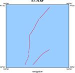
DATA COLLECTION OVERVIEW (use NGDC GEODAS CD to retrieve data)
|
|
|
|
MCG Data Collection ID --- H170NP
|
|
Institution Data Collection ID --- HU931005
|
|
NGDC ID --- 09040022
|
|
Funding --- NAVOCEANO
|
|
Project, Cruise & Leg --- LEG 1,2,3.
|
|
Study region --- +52.00000,+34.00000,+140.00000,-122.00000
|
|
Chief Scientist(s) --- NAVOCEANO CODE 3432
|
|
Name of vessel --- R/V HUNT (surface ship)
|
|
Date field data collection started --- 10/02/70 YOKOYAMA
|
|
Date field data collection ended --- 12/18/70 SAN FRANCISCO
|
|
Parameters surveyed ---
|
|
Bathymetry: surveyed, contained in data file
|
|
Magnetics: surveyed, contained in data file
|
|
Gravity: not surveyed
|
|
High-resolution seismics: surveyed, but not contained in data file
|
|
Deep penetration seismics: surveyed, but not contained in data file
|
|
Format --- (I1,A8,F5.2,4I2,F5.3,F8.5,F9.5,I1,F6.4,F6.1,I2,i1,3F6.1,I1,F5.1,F6.0,F7.1,F6.1,F5.1,A8,4I1)
|
|
Date of data input to NGDC --- 10/15/79
|
|
Contributing institution --- US NAVAL OCEANOGRAPHIC OFFICE
|
|
Country --- USA
|
|
|
|
Navigation instrumentation --- MX-702 SATNAV,LORAN A/C
|
|
Position determination method --- (unspecified)
|
|
|
|
Bathymetry instrumentation --- 12 KHZ 45 DEG EDO TOWED XDUCER 1-SEC SW
|
|
Additional forms of bathymetric data --- ANALOG, MICROFILM
|
|
General rate of bathymetry in file --- 5.0 minutes
|
|
General collection rate of bathymetry --- 1/SECOND
|
|
Assumed sound velocity --- 1430.0 m/sec
|
|
Bathymetric datum code --- No correction applied (sea level)
|
|
Bathmetry interpolation scheme --- SCALED 5- MIN VALUES COMPUTER CONVERTED TO SONIC METERS
|
|
|
|
Magnetics instrumentation --- PROTON PRECESSION - VARAIN SYST
|
|
Additional forms of magnetics data --- ANALOG, MICROFILM
|
|
General rate of magnetics in file --- 5.1 minutes
|
|
General collection rate of magnetics --- (unspecified)
|
|
Magnetic sensor tow distance --- (unspecified)
|
|
Magnetic sensor depth --- (unspecified)
|
|
Two sensor horizontal separation --- (unspecified)
|
|
Residual magnetics reference field --- (unspecified)
|
|
Method of applying residual field --- (unspecified)
|
|
|
|
Seismic instrumentation --- TELEDYNE 30 KJ SPARKER, 4- SEC SWEEP
|
|
Formats of seismic data --- ANALOG , MICROFILM
|
|
|
|
Notes ---
|
|
3.5 KHZ PROFILES COLLECTED EDO 240 SYSTEM
|
|
IN PORT ADAK ADAK701022-701028,OAKLAND 701128-701204.
|