Landmark Map of the West
Charles Preuss (1803-1854)]
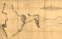
"Map
of an Exploring Expedition to the Rocky Mountains in the year 1842
and to Oregon & North
California in the Years 1843-44 . . ."
from John C. Frémont (1813-1890)
Report of the Exploring Expedition to the Rocky Mountains. . . .
Washington: 1845
Hand-colored engraved map
Geography & Map Division (48A.9)
Digital ID# g4051s ct000909
|
In 1842 and again in 1843-1844, John C. Frémont led expeditions
to survey the route of the Oregon Trail from the Missouri River
to the Columbia River. On his return in 1844, Frémont traveled
into Mexican-held California and then headed east completing a
6,500-mile circuit of the West. Charles Preuss, the expedition's
cartographer, prepared this map, depicting only geographic information
collected during the expedition. Originally published with Frémont's
1845 report, the map was the first reliable depiction of the emigrants'
route through the West since it was based on scientific measurements
of latitude and longitude.
|