The
Forts of Washington
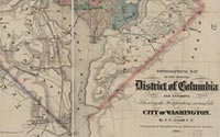
E.G. Arnold, CE
Topographical Map of the Original
District of Columbia and Environs: Showing the Fortifications around
the City of Washington
New York: G. Woolworth Colton, 1862
Hand-colored engraving
Geography & Map Division
(42A.3)
|
The city of Washington was extremely vulnerable to military attack
during the Civil War. In order to remedy the situation, a ring of
sixty-eight fortifications and batteries by the war's close had
been built to encircle the city. This annotated map bears an inscription
on the verso: "This map was suppressed by the Gov't because of the
info it would give the rebels." The Library has the world's foremost
collection of Civil War printed maps.
|