Link to USGS home page
USGS Home
Contact USGS
Search USGS
Coastal & Marine Geology InfoBank

USGS CMG W-33-81-AR Metadata

Skip navigational links
Search InfoBank
Home tab FACS tab Activities tab Atlas tab Geology School tab More tab More tab Activities tabs
   
Activities: by ID   by Platform   by Year   by Region   by Participant   by Organization   by Project/Theme   with Incomplete IDs   Disclaimer  
Activity First Letter: A   B   C   D   E   F   G   H   I   J   K   L   M   N   O   P   Q   R   S   T   U   V   W   X   Y   Z   0   1   2   3   4   5   6   7   8   9  
Virtual Globes: Atlas  (GE)    Samples  (GE)    Illuminate Oceans  (GE)    Earthquakes  (GE)    Get GE    InfoBank examples    State Waters
W-33-81-AR links...
Metadata & Data: Metadata   Navigation   Seismic   nav (GE GM)   seis (GE GM)   times (GE GM)  
Formal Metadata: Frequently-Anticipated Questions   Outline   Parseable Text   XML  
   
   
Metadata
ID W-33-81-AR
Also Known As 00033
Abstract WesternGeco. Geophysical data (navigation, seismic) of field activity W-33-81-AR in Camden Bay from 00/00/1981 to 00/00/1981
Organization WesternGeco
Activity Type Geophysical
Area of Operation
Camden Bay
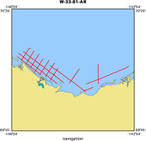
Location map W-33-81-AR location map of where navigation equipment operated
Bounding Coordinates 70.25318
-145.97443    -144.00633
69.98977
Dates 00/00/1981 (JD 000) to 00/00/1981 (JD 000)
Analog Materials No analog holdings.
Index map

W-33-81-AR map of where navigation equipment operated

Information Specialist
Jon Childs
Equipment Used
navigation
seismic
Notes
Description of Survey Area 00033: Camden Bay 1981
Date of Survey Jan/Feb 1981
Tape Version Identifier SEG-P1

Client Name WesternGeco Multiclient
Coordinate Location Vessel Locations
Spheroid Definition-Survey Clarke 1866 6378206.400 294.978698
Spheroid Def. - Post Plot Clarke 1866 6378206.400 294.978698
Geodetic Datum - Survey NAD 27
Geodetic Datum - Post Plot NAD 27

Datum Shifts
Projection Type Transverse Mercator
Grid System UTM Zone 6
Grid Units Meters
Central Meridian 147 0 0.000W
Grid Origin 0 0 0.000N147 0 0.000W
Grid Coordinates at Origin 500000.00E 0.00N
Scale Factor 0.9996000000
Scale Factor Defined at 0 0 0.000N147 0 0.000W

Got Help? For W-33-81-AR, we would appreciate any information on -- analog materials, chief scientist, contract, crew, days at sea, dive count, funding, information to be derived, kms of navigation, national plan, NGDC Info, owner, platform, ports, project, project number, publications, purpose, scanned materials, seismic description, station count, station description, submersible, summary, tabulated info.


Skip footer navigational links


InfoBank   Menlo Park & Santa Cruz Centers   St. Petersburg Center   Woods Hole Center   Coastal and Marine Geology Program   Geologic Information   Ask-A-Geologist   USGS Disclaimer  

FirstGov button   Take Pride in America button