|
|
|
Metadata
|
|
ID
|
N-1-84-EG
|
|
Also Known As
|
N184GB
|
|
Abstract
|
United States Geological Survey, Menlo Park, California.
Chief Scientists: Paul Carlson, Ross Powell. Data (radar,
Geopulse, DelNorte) of field activity N-1-84-EG in Glacier
Bay, Queen Inlet, Wachusett Inlet, Upper Muir Inlet, Eastern
Gulf of Alaska from 06/01/1984 to 06/05/1984
|
|
Organization
|
United States Geological Survey, Menlo Park, California
|
|
Chief Scientist
|
Paul Carlson
Ross Powell
|
|
Platform
|
Nunatak
|
|
Area of Operation
|
Glacier Bay, Queen Inlet, Wachusett Inlet, Upper Muir Inlet, Eastern Gulf of Alaska
|
|
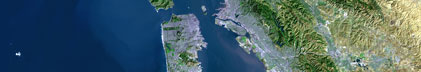
Location map
|

|
|
Bounding Coordinates
|
58.96190
-136.58183 -136.51109
58.86667
|
|
Ports
|
leave Juneau, AK
arrive Juneau, AK
|
|
Dates
|
06/01/1984 (JD 153) to 06/05/1984 (JD 157)
|
|
Analog Materials
|
list
|
|
Index map

|
|
|
Crew
|
|
Paul Carlson
|
Chief Scientist, USGS Western Region
|
|
Ross Powell
|
Chief Scientist, North Illinois University, Dekalb, IL
|
|
Mike Boyle
|
Electrical Technician, USGS Western Region
|
|
Ellen Cowan
|
Graduate Student/watchstander, North Illinois University
|
|
Jim Duncker
|
Graduate Student/watchstander, North Illinois University
|
|
Jim Luthy
|
Captain, M/V Nunatak
|
|
|
Equipment Used
|
|
|
Notes
|
|
Operated off a 3.5 kw Homelite generator.
|
|
|
|
|
NGDC Overview
|
|
! Converted to time format with year at start.
|
|
!
|
|
DATA COLLECTION OVERVIEW (use NGDC GEODAS CD to retrieve data)
|
|
|
|
MCG Data Collection ID --- N184EG
|
|
Institution Data Collection ID --- N184EG
|
|
NGDC ID --- 06890002
|
|
Funding --- (unspecified)
|
|
Project, Cruise & Leg --- (unspecified)
|
|
Study region --- +59.00000,+58.00000,-137.00000,-136.00000
|
|
Chief Scientist(s) --- Paul Carlson
|
|
Name of vessel --- Nunatak (surface ship)
|
|
Date field data collection started --- 06/01/84 (unspecified)
|
|
Date field data collection ended --- 06/03/84 (unspecified)
|
|
Parameters surveyed ---
|
|
Bathymetry: surveyed, contained in data file
|
|
Magnetics: (unspecified)
|
|
Gravity: (unspecified)
|
|
High-resolution seismics: (unspecified)
|
|
Deep penetration seismics: (unspecified)
|
|
Format --- (I1,A8,F5.2,4I2,F5.3,F8.5,F9.5,I1,F6.4,F6.1,I2,i1,3F6.1,I1,F5.1,F6.0,F7.1,F6.1,F5.1,A8,4I1)
|
|
Date of data input to NGDC --- 08/10/87
|
|
Contributing institution --- USGS Branch of Pacific Marine Geology
|
|
Country --- United States
|
|
|
|
Navigation instrumentation --- (unspecified)
|
|
Position determination method --- (unspecified)
|
|
|
|
Bathymetry instrumentation --- (unspecified)
|
|
Additional forms of bathymetric data --- (unspecified)
|
|
General rate of bathymetry in file --- 19.3 minutes
|
|
General collection rate of bathymetry --- (unspecified)
|
|
Assumed sound velocity --- (unspecified)
|
|
Bathymetric datum code --- No correction applied (sea level)
|
|
Bathmetry interpolation scheme --- (unspecified)
|
|
|
|
Magnetics instrumentation --- (unspecified)
|
|
Additional forms of magnetics data --- (unspecified)
|
|
General rate of magnetics in file --- (unspecified)
|
|
General collection rate of magnetics --- (unspecified)
|
|
Magnetic sensor tow distance --- (unspecified)
|
|
Magnetic sensor depth --- (unspecified)
|
|
Two sensor horizontal separation --- (unspecified)
|
|
Residual magnetics reference field --- (unspecified)
|
|
Method of applying residual field --- (unspecified)
|
|
|
|
Gravity instrumentation --- (unspecified)
|
|
Additional forms of gravity data --- (unspecified)
|
|
General rate of gravity in file --- (unspecified)
|
|
General collection rate of gravity --- (unspecified)
|
|
Theoretical gravity formula --- (unspecified)
|
|
Reference system --- (unspecified)
|
|
Corrections applied --- (unspecified)
|
|
Starting land tie --- (unspecified)
|
|
Ending land tie --- (unspecified)
|
|
|
|
Seismic instrumentation --- (unspecified)
|
|
Formats of seismic data --- (unspecified)
|
|
|
Publications
|
|
Carlson, Paul R., Powell, Ross D., and Phillips, Andrew C., 1992, Submarine
|
|
sedimentary features on a fjord delta front, Queen Inlet, Glacier Bay,
|
|
Alaska: Canadian Journal of Earth Science, v. 29, p. 565-573.
|
|
|
Got Help?
|
For N-1-84-EG, we would appreciate any information on -- activity type, contract, days at sea, dive count, funding, information specialist, information to be derived, kms of navigation, national plan, owner, project, project number, purpose, scanned materials, seismic description, station count, station description, submersible, summary, tabulated info.
|
|