|
|
|
Metadata
|
|
ID
|
L-1-91-NC
|
|
Abstract
|
Chief Scientists: Pat Hart, Jill McCarthy. Geophysical data
(3dot5khz, 12khz, uniboom, airgun, airgunmonitor) of field
activity L-1-91-NC in San Francisco Bay from 09/03/1991 to
09/20/1991
|
|
Project/Theme
|
Bay Area Seismic Imaging Experiment (BASIX)
|
|
Chief Scientist
|
Pat Hart
Jill McCarthy
|
|
Activity Type
|
Geophysical
|
|
Platform
|
Samuel Phillips Lee
|
|
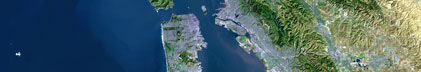
Area of Operation
|
San Francisco Bay
|
|
Location map
|

|
|
Bounding Coordinates
|
38.11173
-123.52004 -121.70993
37.20842
|
|
Dates
|
09/03/1991 (JD 246) to 09/20/1991 (JD 263)
|
|
Analog Materials
|
list
|
|
Index map

|
|
|
Crew
|
|
Al McClenghan
|
Ship Captain
|
|
Chris Poppe
|
Chief Mate, USGS Western Region
|
|
Bill Lafleur
|
Chief Engineer, USGS Western Region
|
|
Jill McCarthy
|
Chief Scientist, USGS Western Region
|
|
Kevin O'Toole
|
Mechanical Technician, USGS Western Region
|
|
Walt Olson
|
Mechanical Technician, USGS Western Region
|
|
Larry Kooker
|
Electronics Technician, USGS Western Region
|
|
Bill Robinson
|
Electronics Technician, USGS Western Region
|
|
Jim Vaughan
|
Electrical Engineer, USGS Western Region
|
|
Dave Hogg
|
Electronics Technician, USGS Western Region
|
|
Kaye Kinoshita
|
Navigator, USGS Western Region
|
|
George Knudson
|
Mechanical Technician, Fairfield
|
|
Steve Higgins
|
Electronics Technician, Fairfield
|
|
Mike Pawlik
|
Electronics Technician, Fairfield
|
|
Tom McEvilly
|
Geophysicist, University of California, Lawrence Berkeley Laboratories
|
|
Pat Hart
|
Geophysicist, USGS Western Region
|
|
Jon Childs
|
Geophysicist, USGS Western Region
|
|
Kevin Furlong
|
Geophysicist, Pennsylvania State University
|
|
Terry Proffer
|
Geophysicist, Haliburton Geophysicist.
|
|
Pat McClellan
|
Geophysicist, City Of San Leandro
|
|
Mike Marlow
|
Watchstander, USGS Western Region
|
|
Kathy Furlong
|
Unspecified Investigator, Pennsylvania State University
|
|
Kate King
|
Unspecified Investigator, CNN
|
|
Rick Blackbird
|
Unspecified Investigator, CNN
|
|
Chris Vincent
|
Unspecified Investigator, CNN
|
|
Gordon Smith
|
Ship Captain, David Johnston
|
|
Mark McLaughlin
|
Unspecified Investigator, David Johnston
|
|
Tom Parsons
|
Unspecified Investigator, Stanford University - David Johnston
|
|
Michael Hamer
|
Navigator, David Johnston, USGS Western Region
|
|
Roberto Anima
|
Ship Captain, Fast Eddy, USGS Western Region
|
|
Shawn Dadisman
|
Unspecified Investigator, Fast Eddy, USGS Western Region
|
|
Armando Buciaga
|
Unspecified Investigator, Fast Eddy, USGS Western Region
|
|
Tom Chase
|
Ship Captain, Chase Boat, USGS Western Region
|
|
Pete Dartnell
|
Unspecified Investigator, Chase Boat, USGS Western Region
|
|
Roy Kiesling
|
Vol. Unspecified Investigator, Chase Boat, USGS Western Region
|
|
Greg Gabel
|
Ship Captain, Caltrans
|
|
Holly Ryan
|
Unspecified Investigator, Caltrans
|
|
David Verdonck
|
Geophysicist, Pennsylvania State University, LLL
|
|
Dennis Mann
|
Ship Captain, Revenge, USGS Western Region
|
|
Ray Sliter
|
Unspecified Investigator, Revenge, USGS Western Region
|
|
Joe Svitek
|
Unspecified Investigator, Revenge, USGS Western Region
|
|
Rich Clymer
|
Unspecified Investigator, Mako, USGS Western Region
|
|
Pat Williams
|
Unspecified Investigator, Mako, USGS Western Region
|
|
Peter Barnes
|
Ship Captain, R/V Estero, USGS Western Region
|
|
Erik Gize
|
Unspecified Investigator, R/V Estero, USGS Western Region
|
|
Jean Riordan
|
Unspecified Investigator, USGS Western Region
|
|
Norman Maher
|
Unspecified Investigator, USGS Western Region
|
|
Vicky Goetcheus
|
Unspecified Investigator, USGS Western Region
|
|
Dave Scholl
|
Geophysicist, USGS Western Region
|
|
Eleni Karageorgi
|
Unspecified Investigator, Lawrence Berkeley Laboratories
|
|
Joel Rosenbaum
|
Photographer, Vacaville Reporter
|
|
Robert Reed
|
Unspecified Investigator, Vacaville Reporter
|
|
George Thompson
|
Geophysicist, Stanford University
|
|
Ben Page
|
Geophysicist, USGS Western Region
|
|
David McMahon
|
Unspecified Investigator, BC&DC
|
|
Doug Prose
|
Photographer, USGS Western Region
|
|
Nina Luttinger
|
Photographer, USGS Western Region
|
|
Tracy Vallier
|
Geologist, USGS Western Region
|
|
Andy Michael
|
Geophysicist, USGS Western Region
|
|
Stephanie Ross
|
Navigator, USGS Western Region
|
|
Diana Collins
|
Unspecified Investigator, USGS Western Region
|
|
June Matsueyda
|
Unspecified Investigator, USGS Western Region
|
|
|
Equipment Used
|
|
3dot5khz
|
|
12khz
|
|
uniboom
|
|
airgun
|
|
airgunmonitor
|
|
|
Purpose
|
|
Furlong and others (1989) proposed the possibility that the network
|
|
of faults that bound the San Francisco Bay Area are linked structurally and
|
|
are all part of an evolving fault system. To test the Furlong and others (1989)
|
|
model and to obtain fundamental information on the crustal structure and fault
|
|
geometries that underlie the San Francisco Bay Area, the USGS, in conjunction
|
|
with the University of California, Stanford University, Pennsylvania State
|
|
University, and Lawrence Berkeley Laboratory, conducted a major seismic
|
|
reflection investigation in the fall of 1991 utilizing the marine waterway
|
|
system that dissects the Bay Area. This study, known as the Bay Area Seismic
|
|
Imaging Experiment (BASIX) consisted of three complementary seismic
|
|
reflection and refraction profiling methods: high resolution seismic reflection
|
|
profiling, wide-angle reflection/refraction profiling, and multichannel
|
|
seismic profiling. The high-resolution, shallow penetration data were
|
|
acquired to constrain near-surface faulting, while the wide-angle reflection/
|
|
refraction data were acquired to constrain the deep-crustal velocity
|
|
structure of the crust. (Open-File Report 93-301).
|
|
|
Information to be Derived
|
|
Three complementary seismic reflection and refraction profiling
|
|
methods: high resolution seismic reflection profiling, wide-angle
|
|
reflection/refraction profiling, and multichannel seismic profiling. The
|
|
high-resolution, shallow penetration data were acquired to constrain
|
|
near-surface faulting, while the wide-angle reflection/refraction data were
|
|
acquired to constrain the deep-crustal velocity structure of the crust.
|
|
(Open-File Report 93-301).
|
|
|
Summary
|
|
A total of 140 km of multichannel reflection data were acquired across
|
|
the San Francisco Bay Area during 14 nights of profiling. Although each night
|
|
of profiling was assigned a different line number, several of the lines overlap
|
|
and they were thus processed together as merged profiles. All totaled, there
|
|
were four distinct segments to the experiment. The first segment began in
|
|
the Sacramento River near Rio vista and proceeded west through Honker, Suisun,
|
|
and San Pablo Bays (lines 101 through 110). The next two segments ran north-
|
|
south from Richmond to Angel Island (line 113), and from the Bay Bridge to
|
|
just north of the San mateo Bridge (line 111). The fourth and final segment
|
|
began in the vicinity of Alcatraz Island and extended west underneath the
|
|
Golden Gate Bridge, 6 km into the open waters of the Pacific (lines 201-202).
|
|
|
|
60 to 118 Telseis receivers were moored to the edge of the dredged shipping
|
|
channel at 100 to 200 m intervals for a fixed spread of 6 to 12 km in length.
|
|
Each day the receiver array was repositioned, and each night the S.P. Lee
|
|
steamed along the hydrophone array, with its airgun array firing.
|
|
|
|
The day-to-day small-boat operations began first with the retrieval of the
|
|
Telseis instruments deployed the previous day. This process utilized a fleet
|
|
of 4-5 small boats that ranged in size from 6 to 15 m. Once retreived, the
|
|
instruments were brought back to the S.P. Lee for recharging. The R.V. David
|
|
Johnston trailed behind these small vessels and recovered the associated buoys
|
|
and anchors. The Johnston also recorded navigational fixes, which were
|
|
required in order to check for possible drift of the instrument sites during
|
|
the night; although anchors were used to maintain instrument position, currents
|
|
were strong enough in a few areas to move the anchors between deployment and
|
|
retrieval.
|
|
|
|
Once the instrument retrieval was complete, the Johnston would begin laying
|
|
out the next line segment. A GPS and Del Norte triangulation system were used
|
|
to measure the 100- or 200-m distance separating instrument sites. The
|
|
receiver line was positioned so as to minimize bends in the profile and to
|
|
keep the buoys out of the active shipping channel. At each site, anchors
|
|
were deployed and navigation fixes were taken; the anchored sites were marked by orange buoys. The smaller boats followed behind and clipped the recharged
|
|
Telseis units with cabled hydrophones to these buoys. The hydrophones were
|
|
weighted so as to minimize movement on the seafloor.
|
|
|
|
The final phase of operation was airgun profiling. Each night the S.P. Lee
|
|
acquired approximately 24 km of reflection data by looping through the
|
|
receiver array twice. Along 10 of the 13 multichannel lines the S.P. Lee fired
|
|
the airgun array while steaming first from east to west and then, reversing
|
|
course, duplicated the line by steaming from west to east, further doubling
|
|
the number of airgun shots available for stacking of the seismic signal.
|
|
|
|
In addition to the 13 reflection lines acquired in San Francisco Bay and the
|
|
Golden Gate region, the airgun array on the S.P. Lee was used primarily as a
|
|
seismic source for wide-angle profiles recorded along three other lines: the
|
|
N-S trending line OBS1 in San Francisco Bay; a short transit leg, line TR1
|
|
SW of the Golden Gate; and the E-W trending line OBS2 on the continental margin.
|
|
Lines OBS1 and OBS2 were obtained along two separate deployment of 6 USGS ocean bottom seismometers (OBS) deployed by investigators from the USGS Branch of
|
|
Atlantic Marine Geology and Woods Hole Oceanographic Institution. The shot
|
|
interval along line 112/OBS1 was 50 m. The shot interval for lines TR1 and
|
|
OBS2 was approximately 75 m. Line OBS2 was located coincident to seismic
|
|
reflection line 13 of Lewis (1990) in order to provide deep structural control
|
|
on the continental margin west of the San Andreas fault.
|
|
|
Publications
|
|
Anima, R.J., Williams, Patrick L., and McCarthy, J., 1992, High-resolution marine
|
|
seismic reflection profiles across East Bay faults, in Galehouse, Jon S., ed.,
|
|
Programs and abstracts of the Second conference on Earthquake hazards in the
|
|
eastern San Francisco Bay area: California Division of Mines and Geology Special
|
Publication, v. 113, p. 4.
|
|
|
Hart, P.E., Clymer, R.W., and Karageorgi, E.D., 1992, Geometry of the San Francisco
|
|
Bay area faults; preliminary results from BASIX, in Galehouse, Jon S., ed.,
|
|
Programs and abstracts of the Second conference on Earthquake hazards in the
|
|
eastern San Francisco Bay area: California Division of Mines and Geology Special
|
Publication, v. 113, p. 30.
|
|
|
McEvilly, T.V., and McCarthy, Jill, 1992, BASIX; the Bay Area Seismic Imaging
|
|
Experiment report, in Galehouse, Jon S., ed., Programs and abstracts of the Second
|
|
conference on Earthquake hazards in the eastern San Francisco Bay area: California
|
Division of Mines and Geology Special Publication, v. 113, p. 47.
|
|
|
McCarthy, Jill, and Hart, Patrick E., 1993, Data report for the 1991 Bay area
|
|
seismic imaging experiment (BASIX): U.S. Geological Survey Open-File Report 93-0301,
|
26 p.
|
|
|
Hart, P., McCarthy, J., Karageorgi, E., and McEvilly, T., 1993, Seismic reflection
|
|
profiling in the San Francisco Bay area; the 1991 Bay Area Seismic Imaging Experiment
|
|
(BASIX): Geological Society of America Abstracts with Programs, v. 25, no. 6,
|
p. 417-418.
|
|
|
McCarthy, J., Hart, P., Karageorgi, E., and McEvilly, T., 1993, Seismic profiling across
|
|
an evolving transform margin; results from the 1991 Bay Area Seismic Imaging eXperiment
|
(BASIX): Geological Society of America Abstracts with Programs, v. 25, no. 6, p. 310.
|
|
|
Brocher, Thomas M., McCarthy, Jill, Hart, Patrick E., Holbrook, W. Steven, Furlong, Kevin P.,
|
|
McEvilly, Thomas V., Hole, John A., and Klemperer, Simon L., 1994, Seismic evidence for a
|
|
lower-crustal detachment beneath San Francisco Bay, California: Science, v. 265, no. 5177,
|
p. 1436-1439.
|
|
|
Childs, J.R., Hart, P.E., McCarthy, J., and Marlow, M.S., 1994, High-resolution
|
|
seismic-reflection studies of submerged fault zones throughout the San Francisco Bay
|
area: American Geophysical Union Eos, Transactions, v. 75, no. 44, Supplement, p. 684.
|
|
|
McCarthy, J., Hart, P.E., Anima, R., Oppenheimer, D., and Parsons, T., 1994, Seismic
|
|
evidence for faulting in the western Sacramento Delta region, Pittsburg, California:
|
American Geophysical Union Eos, Transactions, v. 75, no. 44, Supplement, p. 684-685.
|
|
|
McCarthy, J., Hart, P.E., and Oppenheimer, D., 1995, High angle faulting in western
|
|
Sacramento Delta region, Pittsburg, California: American Association of Petroleum
|
Geologists Bulletin, v. 79, no. 4, p. 592.
|
|
|
Parsons, Tom, McCarthy, Jill, and Hart, P.E., 1994, The nature of lower crustal reflectors
|
|
beneath San Francisco Bay, California: American Geophysical Union Eos, Transactions, v. 75,
|
no. 44, Supplement, p. 643.
|
|
|
Williams, P.L., McEvilly, T.V., Anima, R., McCarthy, J., Nakata, T., Okamura, M., and
|
|
Shimazaki, K., 1993, Fault activity, geometry, and recurrence behavior at the junction of
|
|
the Rodgers Creek and Pinole faults, California: American Geophysical Union Eos,
|
Transactions, v. 74, no. 43, Supplement, p. 411.
|
|
|
Holbrook, W. Steven, Brocher, T.M., McCarthy, Jill, Hole, J.A., and ten Brink, U.S., 1994,
|
|
Crustal structure beneath the San Francisco Bay Block and Central California continental
|
margin: American Geophysical Union Eos, Transactions, v. 75, no. 44, Supplement, p. 664.
|
|
|
Pope, D.C., Brocher, T.M., McCarthy, J., Karageorgi, E.D., and Holbrook, W.S., 1993, Comparison
|
|
of recording technology for onshore-offshore seismic profiling of continental margins; examples
|
from BASIX: American Geophysical Union Eos, Transactions, v. 74, no. 43, Supplement, p. 445.
|
|
|
Brocher, Thomas M., McCarthy, Jill, and Holbrook, W. Steven, 1996, Imaging the transform
|
|
plate boundary in the San Francisco Bay area, California: Geological Society of America
|
Abstracts with Programs, v. 28, no. 7, p. 216.
|
|
|
Brocher, Thomas M., and Moses, Michael J., 1993, Onshore-offshore wide-angle seismic
|
|
recordings of the San Francisco Bay Area Seismic Imaging Experiment (BASIX): the five-day
|
recorder data: U.S. Geological Survey Open-File Report 93-276, 89 p.
|
|
|
Got Help?
|
For L-1-91-NC, we would appreciate any information on -- contract, days at sea, dive count, funding, information specialist, kms of navigation, national plan, NGDC Info, notes, organization, owner, ports, project number, scanned materials, seismic description, station count, station description, submersible, tabulated info.
|
|