|
|
|
Metadata
|
|
ID
|
98030
|
|
Also Known As
|
98030
PERL98030
P-30-98-LA
|
|
Abstract
|
United States Geological Survey, Woods Hole, Massachusetts.
Chief Scientists: Rich Signell, Shea Penland. Data
(navigation) of field activity 98030 (P-30-98-LA) in
Louisiana Lake Pontchartrain from 05/06/1998 to 05/06/1998
|
|
Organization
|
United States Geological Survey, Woods Hole, Massachusetts
|
|
Chief Scientist
|
Rich Signell
Shea Penland
|
|
Platform
|
Pearl Barge
|
|
Area of Operation
|
Louisiana Lake Pontchartrain
|
|
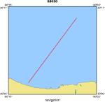
Location map
|
|
|
Bounding Coordinates
|
30.20000
-90.25000 -90.00000
30.00000
|
|
Dates
|
05/06/1998 (JD 126) to 05/06/1998 (JD 126)
|
|
Analog Materials
|
No analog holdings.
|
|
Index map

|
|
|
Crew
|
|
Rich Signell
|
Chief Scientist, USGS Woods Hole
|
|
Shea Penland
|
Chief Scientist, UNO
|
|
J. D. Ouzts
|
Ship Captain, Pearl River
|
|
Rick Rendigs
|
Diver, USGS Woods Hole
|
|
Dann Blackwood
|
Diver, USGS Woods Hole
|
|
Marinna Martini
|
Unspecified, USGS Woods Hole
|
|
Alex McQuorkodale
|
Scientist, University of New Orleans
|
|
|
Equipment Used
|
|
|
Purpose
|
|
|
Got Help?
|
For 98030, we would appreciate any information on -- activity type, analog materials, contract, days at sea, dive count, funding, information specialist, information to be derived, kms of navigation, national plan, NGDC Info, notes, owner, ports, project, project number, publications, scanned materials, seismic description, station count, station description, submersible, summary, tabulated info.
|
|


