|
|
|
|
Metadata
|
|
ID
|
04015
|
|
Also Known As
|
04015
O-1-04-MA
|
|
Abstract
|
United States Geological Survey, Woods Hole, Massachusetts.
Chief Scientists: Brad Butman, USGS Woods Hole, Larry Mayer,
University of New Hampshire, Susan Snow-Cotter, Mass CZM.
Data (SAIC will carry out this work using the R/V
OceanExplorer, under subcontract to the University of New
Hampshire (UNH)., Reson 8101 24 kHz, TSS POS/MV, Brooke Ocean
Technology MVP30) of field activity 04015 (O-1-04-MA) in
Southern Merrimack Embayment, Western Gulf of Maine, from
02/23/2004 to 03/16/2004
|
|
Organization
|
United States Geological Survey, Woods Hole, Massachusetts
|
|
Project/Theme
|
Southern Merrimack Embayment Multibeam Survey
|
|
Chief Scientist
|
Brad Butman
Larry Mayer
Susan Snow-Cotter
|
|
Platform
|
Oceanexplorer
|
|
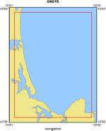
Area of Operation
|
Southern Merrimack Embayment, Western Gulf of Maine,
|
|
Location map
|
|
|
Bounding Coordinates
|
42.88333
-70.83333 -70.60000
42.65000
|
|
Ports
|
FEB 23, 2004 - Gloucester, MA
MAR 16, 2004 - Gloucester, MA
|
|
Dates
|
02/23/2004 (JD 054) to 03/16/2004 (JD 076)
|
|
Analog Materials
|
No analog holdings.
|
|
Index map

|
|
|
Information Specialist
|
|
Brian Andrews USGS Woods Hole
|
|
William Danforth USGS Woods Hole
|
|
|
Crew
|
|
Brad Butman
|
USGS Woods Hole, Chief Scientist
|
|
Susan Snow-Cotter Mass CZM
|
Chief Scientist
|
|
William Danforth USGS Woods Hole (data quality and archive)
|
|
Larry Mayer
|
University of New Hampshire, Chief Scientist
|
|
Brian Andrews
|
USGS Woods Hole
|
|
|
Equipment Used
|
|
SAIC will carry out this
|
(work using the R/V OceanExplorer )
|
|
under subcontract to the
|
(University of New Hampshire (UNH).)
|
|
Reson 8101 24 kHz
|
|
TSS POS/MV
|
|
Brooke Ocean Technology M
|
(VP30)
|
|
|
Purpose
|
|
Carry out multibeam survey (bathymetry and backscatter
|
|
|
Information to be Derived
|
|
Sea Floor Map;Bathymetric Maps;Morphology;
|
|
|
Summary
|
|
Science Application International Corporation was contracted
|
|
|
Notes
|
|
Navigation Techniques: DGPS
|
|
Navigation Techniques: This cruise was carried out under contract to the University
|
|
SAIC will carry out this work using the R.V. Oceanexplorer under subcontract to the University of New Hampshire (UNH)
|
|
Reson 8101 24 kHz
|
|
Brooke Ocean Technology MVP30
|
|
TSS POS/ MV
|
|
|
Got Help?
|
For 04015, we would appreciate any information on -- activity type, analog materials, contract, days at sea, dive count, funding, kms of navigation, national plan, NGDC Info, owner, project number, publications, scanned materials, seismic description, station count, station description, submersible, tabulated info.
|
|