|
|
|
|
Metadata
|
|
ID
|
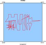
01052
|
|
Also Known As
|
01052
F-1-01-GM
|
|
Abstract
|
United States Geological Survey, Woods Hole,
Massachusetts,United States Geological Survey, Biological
Resources Division, Gainesville,Texas A&M Applied
Research,National Oceanic and Atmospheric Administration.
Sampling data (VanVeengrab, digitalcamera) of field activity
01052 (F-1-01-GM) in Flower Gardens, Northwest Gulf of Mexico
from 05/27/2001 to 06/02/2001
|
|
Organization
|
United States Geological Survey, Woods Hole, Massachusetts
United States Geological Survey, Biological Resources Division, Gainesville
Texas A&M Applied Research
National Oceanic and Atmospheric Administration
|
|
Project/Theme
|
Flower Gardens Habitat Mapping
|
|
Activity Type
|
Sampling
|
|
Platform
|
Ferrel
|
|
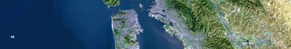
Area of Operation
|
Flower Gardens, Northwest Gulf of Mexico
|
|
Location map
|
|
|
Bounding Coordinates
|
28.00283
-93.93380 -93.40450
27.78950
|
|
Ports
|
leave Galveston, TX
arrive Galveston, TX
|
|
Dates
|
05/27/2001 (JD 147) to 06/02/2001 (JD 153)
|
|
Analog Materials
|
No analog holdings.
|
|
Index map

|
|
|
Crew
|
|
Kathy Scanlon
|
Unspecified, USGS Woods Hole
|
|
Doug Weaver
|
Unspecified, USGS BRD, Gainesville, FL
|
|
Jill Rozycki
|
Sampling Geologist
|
|
Dave Walsh
|
Sampling Tech
|
|
James Piper
|
Biological Sampling and UW Video, Texas AM Applied Research Laboratories
|
|
Roger Banks
|
UW Video, Texas AM Applied Research Laboratories
|
|
Kevin Buch
|
UW Video, NOAA Sanctuary Program
|
|
Scott Kuester
|
Captain, NOAA
|
|
|
Equipment Used
|
|
VanVeengrab
|
|
digitalcamera
|
|
|
Purpose
|
|
Sediment sampling of the sanctuary and nearby areas for habitat mapping
|
|
|
Summary
|
|
|
Notes
|
|
Navigation techniques: Nobeltec Visual Suite
|
|
|
|
|
Got Help?
|
For 01052, we would appreciate any information on -- analog materials, chief scientist, contract, days at sea, dive count, funding, information specialist, information to be derived, kms of navigation, national plan, NGDC Info, owner, project number, publications, scanned materials, seismic description, station count, station description, submersible, tabulated info.
|
|