|
|
|
Metadata
|
|
ID
|
94CCT01
|
|
Also Known As
|
G-1-94-GM
|
|
Abstract
|
United States Geological Survey, St. Petersburg, Florida.
Chief Scientist: Jack Kindinger. Geophysical data (boomer,
GPS) of field activity 94CCT01 (G-1-94-GM) in Sabine Lake,
Neches River, Black Bayou, Gulf of Mexico from 06/27/1994 to
06/30/1994
|
|
Organization
|
United States Geological Survey, St. Petersburg, Florida
|
|
Project/Theme
|
Coastal Change and Transport
Coastal Change Hazards
|
|
Chief Scientist
|
Jack Kindinger
|
|
Activity Type
|
Geophysical
|
|
Platform
|
Gilbert
|
|
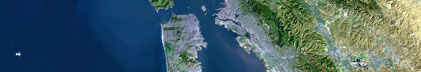
Area of Operation
|
Sabine Lake, Neches River, Black Bayou, Gulf of Mexico
|
|
Location map
|
|
|
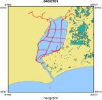
Bounding Coordinates
|
30.02720
-93.98099 -93.72073
29.64400
|
|
Ports
|
leave Sabine Pass, TX
arrive Sabine Pass, TX
|
|
Dates
|
06/27/1994 (JD 178) to 06/30/1994 (JD 181)
|
|
Analog Materials
|
list
|
|
Index map

|
|
|
Information Specialist
|
|
|
Crew
|
|
Jack Kindinger
|
Chief Scientist, USGS St. Petersburg, FL
|
|
Jim Flocks
|
Geologist, USGS St. Petersburg, FL
|
|
Robert Morton
|
Geologist, UT BEG Austin, TX
|
|
Dana Wiese
|
Electronics Technician, USGS St. Petersburg, FL
|
|
Keith Ludwig
|
Boat Captain, USGS St. Petersburg, FL
|
|
J. Green
|
Boat Captain, NOAA Corps, Washington, DC
|
|
|
Equipment Used
|
|
|
Purpose
|
|
Geologic framework and coastal processes study.
|
|
|
Information to be Derived
|
|
|
Summary
|
|
|
Notes
|
|
94CCT01 FACS logs were generated by Karynna Calderon
|
|
in September of 2003 using the handwritten logbooks
|
|
and personal accounts of the crew members.
|
|
|
Publications
|
|
Calderon, K., Dadisman, S.V., Kindinger, J.L., Flocks, J.G., Morton, R.A., and
|
|
Wiese, D.S., 2004, Archive of Digital Boomer Seismic Reflection Data Collected
|
|
During USGS Cruises 94CCT01 and 95CCT01, Eastern Texas and Western Louisiana,
|
|
1994 and 1995, U.S. Geological Survey Data Series 93, available on-line at:
|
|
|
Data Series 93
|
|
|
|
publication metadata
|
|
|
Got Help?
|
For 94CCT01, we would appreciate any information on -- contract, days at sea, dive count, funding, kms of navigation, national plan, NGDC Info, owner, project number, scanned materials, seismic description, station count, station description, submersible, tabulated info.
|
|