|
|
|
Metadata
|
|
ID
|
B-1-94-PS
|
|
Also Known As
|
WA94
|
|
Abstract
|
United States Geological Survey, Menlo Park, California.
Chief Scientist: George Tate. Geological data
(underwatercamera, suspendedsediment, Geoprobe,
transmissometer, thermistor, currentmeter, watersamples,
CTDmeter, pressuregauge) of field activity B-1-94-PS in
Sinclair Inlet, Puget Sound, Washington from 02/18/1994 to
03/29/1994
|
|
Organization
|
United States Geological Survey, Menlo Park, California
|
|
Project/Theme
|
Bremerton Sediment Transport Study
|
|
National Plan
|
Environment
|
|
Chief Scientist
|
George Tate
|
|
Activity Type
|
Geological
|
|
Area of Operation
|
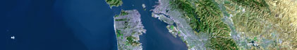
Sinclair Inlet, Puget Sound, Washington
|
|
Location map
|

|
|
Bounding Coordinates
|
50.00000
-126.00000 -122.00000
47.00000
|
|
Dates
|
02/18/1994 (JD 049) to 03/29/1994 (JD 088)
|
|
Analog Materials
|
No analog holdings.
|
|
Index map

|
|
|
Crew
|
|
George Tate
|
Chief Scientist, USGS Western Region
|
|
|
Equipment Used
|
|
underwatercamera
|
|
suspendedsediment
|
|
Geoprobe
|
|
transmissometer
|
|
thermistor
|
|
currentmeter
|
|
watersamples
|
|
CTDmeter
|
|
pressuregauge
|
|
|
Purpose
|
|
This was a cooperative study with WRD to study sediment resuspension
|
|
and transport for the Bremerton Naval Facility. Data were collected and
|
|
submitted to the Navy's prime contractor for analysis and development of a
|
|
sediment/polutant transport model.
|
|
|
Summary
|
|
Deployed equipment to gather tidal, current, and transmissivity data over a 5 week period.
|
|
|
Notes
|
|
Anticipated date of data input into USGS data base: November 1994.
|
|
Related field activities: B294PS
|
|
|
|
WA94 used for combined B194PS and B294PS as internal project documentation.
|
|
|
Got Help?
|
For B-1-94-PS, we would appreciate any information on -- analog materials, contract, days at sea, dive count, funding, information specialist, information to be derived, kms of navigation, NGDC Info, owner, platform, ports, project number, publications, scanned materials, seismic description, station count, station description, submersible, tabulated info.
|
|