|
|
|
Metadata
|
|
ID
|
03041
|
|
Also Known As
|
03041
A-5-03-MA
A503MA
|
|
Abstract
|
United States Geological Survey, Woods Hole,
Massachusetts,Woods Hole Oceanographic Institution. Chief
Scientists: Dave Foster, Steve Swift. Geophysical data
(Kleinsidescan, Chirp, sidescansonar, GPS) of field activity
03041 (A-5-03-MA) in Vineyard Sound, Falmouth Massachusetts,
United States, North America, North Atlantic from 09/02/2003
to 09/10/2003
|
|
Organization
|
United States Geological Survey, Woods Hole, Massachusetts
Woods Hole Oceanographic Institution
|
|
Chief Scientist
|
Dave Foster
Steve Swift
|
|
Activity Type
|
Geophysical
|
|
Platform
|
Asterias
|
|
Area of Operation
|
Vineyard Sound, Falmouth Massachusetts, United States, North America, North Atlantic
|
|
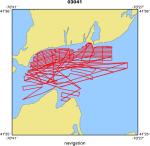
Location map
|
|
|
Bounding Coordinates
|
41.54922
-70.66600 -70.46656
41.46596
|
|
Ports
|
leave Woods Hole
arrive Woods Hole
|
|
Dates
|
09/02/2003 (JD 245) to 09/10/2003 (JD 253)
|
|
Analog Materials
|
No analog holdings.
|
|
Index map

|
|
|
Crew
|
|
Dave Foster
|
Chief Scientist, Data acquistion and processing, USGS Woods Hole
|
|
Tom O'Brien
|
Technician, USGS Woods Hole
|
|
Steve Swift
|
Chief Scientist, WHOI
|
|
Ann Mulligan
|
WHOI
|
|
|
Equipment Used
|
|
Kleinsidescan
|
|
Chirp
|
|
sidescansonar
|
|
GPS
|
|
|
Purpose
|
|
Subbottom survey of Vineyard Sound using Edgetech 512i Chirp system.
|
|
The survey objective is to collect a grid of subbottom data to define the
|
|
Quaternary geologic framework of the area in relation to the onshore geology.
|
|
|
Information to be Derived
|
|
|
Summary
|
|
|
Notes
|
|
Navigation Techniques: DGPS. WHOI's platform.
|
|
|
Got Help?
|
For 03041, we would appreciate any information on -- analog materials, contract, days at sea, dive count, funding, information specialist, kms of navigation, national plan, NGDC Info, owner, project, project number, publications, scanned materials, seismic description, station count, station description, submersible, tabulated info.
|
|


