|
|
|
Metadata
|
|
ID
|
96047
|
|
Also Known As
|
96047
RITA96047
R-47-96-NR
|
|
Abstract
|
United States Geological Survey, Woods Hole, Massachusetts.
Chief Scientists: Bill Schwab, Rob Thieler, Orrin Pilkey.
Data (navigation) of field activity 96047 (R-47-96-NR) in
North Carolina Wrightsville Beach from 09/10/1996 to
09/11/1996
|
|
Organization
|
United States Geological Survey, Woods Hole, Massachusetts
|
|
Chief Scientist
|
Bill Schwab
Rob Thieler
Orrin Pilkey
|
|
Platform
|
Ritas Ride
|
|
Area of Operation
|
North Carolina Wrightsville Beach
|
|
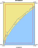
Location map
|
|
|
Bounding Coordinates
|
34.50000
-77.85000 -77.50000
34.10000
|
|
Dates
|
09/10/1996 (JD 254) to 09/11/1996 (JD 255)
|
|
Analog Materials
|
No analog holdings.
|
|
Index map

|
|
|
Crew
|
|
Bill Schwab
|
Chief Scientist, USGS Woods Hole
|
|
Rob Thieler
|
Chief Scientist, Duke
|
|
Mike Merritt
|
Ship Captain, Meridon Corp
|
|
Orrin Pilkey
|
Chief Scientist, Duke U.
|
|
Neal Gielstra
|
Technician, CCU
|
|
|
Equipment Used
|
|
|
Purpose
|
|
|
Publications
|
|
Cruise Report exists at Woods Hole
|
|
|
Got Help?
|
For 96047, we would appreciate any information on -- activity type, analog materials, contract, days at sea, dive count, funding, information specialist, information to be derived, kms of navigation, national plan, NGDC Info, notes, owner, ports, project, project number, scanned materials, seismic description, station count, station description, submersible, summary, tabulated info.
|
|


