|
|
|
Metadata
|
|
ID
|
F-7-90-NC
|
|
Also Known As
|
FRNLF7-90-NC
F-7-90-NC
90018
FRNLF7-90-NC
|
|
Abstract
|
United States Geological Survey, Menlo Park, California.
Chief Scientists: Herman Karl, Dave Drake, Bill Schwab.
Geophysical data (integratednavigation, rangerange, GPS,
RhoRho, bottomtransponder, 3dot5khz, 4dot5khz, 10khz,
sidescansonar) of field activity F-7-90-NC in Gulf of
Farallones, Northern California from 07/19/1990 to
08/03/1990
|
|
Organization
|
United States Geological Survey, Menlo Park, California
|
|
Chief Scientist
|
Herman Karl
Dave Drake
Bill Schwab
|
|
Activity Type
|
Geophysical
|
|
Platform
|
Farnella
|
|
Area of Operation
|
Gulf of Farallones, Northern California
|
|
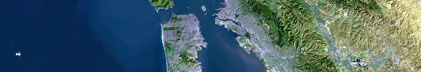
Location map
|

|
|
Bounding Coordinates
|
37.83449
-123.63171 -122.19323
37.10913
|
|
Ports
|
leave Redwood City, CA
arrive Redwood City, CA
|
|
Dates
|
07/19/1990 (JD 200) to 08/03/1990 (JD 215)
|
|
Analog Materials
|
list
|
|
Index map

|
|
|
Crew
|
|
Herman Karl
|
Chief Scientist, USGS Western Region
|
|
Dave Drake
|
Chief Scientist, USGS Western Region
|
|
Bill Schwab
|
Chief Scientist, USGS Woods Hole
|
|
John Cannan
|
Captain, J. Marr and Sons
|
|
Bill Danforth
|
Geologist, USGS Woods Hole
|
|
Barry Irwin
|
Navigator, USGS Woods Hole
|
|
Tom O'Brien
|
Geophysicist, USGS Woods Hole
|
|
John Chin
|
Geologist, USGS Western Region
|
|
Doug Musser
|
Navigator, USGS Western Region
|
|
Kaye Kinoshita
|
Navigator, USGS Western Region
|
|
Tom Crook
|
Navigator, WHOI, DSL
|
|
Ledabeth Pickthorn
|
Navigator, USGS Western Region
|
|
Warren Scherfius
|
Photographer, USGS Western Region
|
|
Steve Wessels
|
Photographer, USGS Western Region
|
|
Larry Kooker
|
Electronics, USGS Western Region
|
|
Kevin Redman
|
Unsp. Inv., IDSS
|
|
Alan Ota
|
Unsp. Inv., EPA
|
|
Kirk O'Donnell
|
Unsp. Inv., IDSS
|
|
Tom Dettweiler
|
Unsp. Inv., Meridan
|
|
Chester Alysta
|
Unsp. Inv., IDSS
|
|
Dave Wyatt
|
Unsp. Inv., Meridan
|
|
Ski Laniewicz
|
Unsp. Inv., IDSS
|
|
Art Wright
|
Unsp. Inv., IDSS
|
|
Matthew Gilbey
|
Chief Engineer, J. Marr
|
|
Albert Fuller
|
Chief Mate, J. Marr
|
|
|
Equipment Used
|
|
integratednavigation
|
|
rangerange
|
|
GPS
|
|
RhoRho
|
|
bottomtransponder
|
|
3dot5khz
|
|
4dot5khz
|
|
10khz
|
|
sidescansonar
|
|
|
Notes
|
|
EPA Gulf of the Farallones
|
|
|
Got Help?
|
For F-7-90-NC, we would appreciate any information on -- contract, days at sea, dive count, funding, information specialist, information to be derived, kms of navigation, national plan, NGDC Info, owner, project, project number, publications, purpose, scanned materials, seismic description, station count, station description, submersible, summary, tabulated info.
|
|