|
|
|
Metadata
|
|
ID
|
T-1-96-NC
|
|
Also Known As
|
TN062
|
|
Abstract
|
Chief Scientist: Homa Lee. Mooring Redeployment and
Sampling data (boxcore, pistoncore, CTDmeter, multibeam) of
field activity T-1-96-NC in Eel River Margin, Northern
California from 07/13/1996 to 07/18/1996
|
|
Project/Theme
|
Strata Formations on Margins (Strataform)
|
|
Chief Scientist
|
Homa Lee
|
|
Activity Type
|
Mooring Redeployment and Sampling
|
|
Platform
|
Thomas G. Thompson
|
|
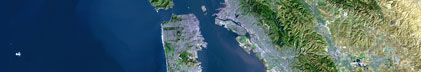
Area of Operation
|
Eel River Margin, Northern California
|
|
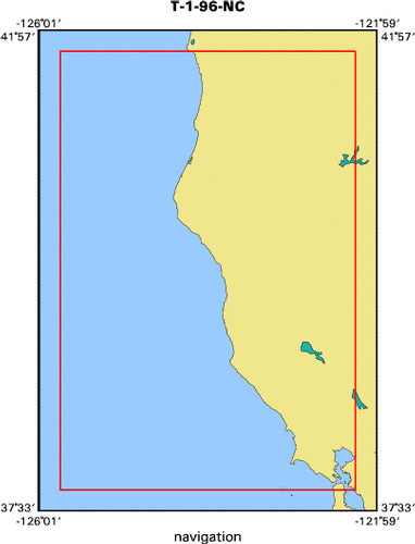
Location map
|

|
|
Bounding Coordinates
|
41.75000
-125.75000 -122.25000
37.75000
|
|
Dates
|
07/13/1996 (JD 195) to 07/18/1996 (JD 200)
|
|
Analog Materials
|
list
|
|
Index map
|
|
|
Information Specialist
|
|
Ken Israel, Multi-sensor Whole Core Logger And Box Core Subsampler
|
|
|
Crew
|
|
Homa Lee
|
Chief Scientist, USGS Western Region
|
|
|
Equipment Used
|
|
boxcore
|
|
pistoncore
|
|
CTDmeter
|
|
multibeam
|
|
|
Purpose
|
|
STRATA FORmation on Margins (STRATAFORM)
|
|
was initiated in 1994 by the Office of Naval Research as a coordinated
|
|
multi-investigator study of continental-margin sediment transport
|
|
processes and stratigraphy. The program is investigating the stratigraphic
|
|
signature of the shelf and slope portions of continental margins, and
|
|
hopes to provide better understanding of the sedimentary record and
|
|
better prediction of strata.
|
|
|
Information to be Derived
|
|
cores were analyzed using a multi-sensor core logger, yielding P-wave velocity, wet bulk density, and magnetic susceptibility data. Atlas Hydrosweep
|
|
multibeam echosounder bathymetric data, gridded at 2.16" (~60m) resolution.
|
|
This system is designed for surveys in continental shelf areas down to depths
|
|
of 4000 m with a swath width of up to 6 times the water depth, with an operating
|
|
frequency of kHz. It provides 160 beams.
|
|
|
Summary
|
|
20 box cores, 12 piston cores, and 3 Kasten cores, along with 4 CTD
|
|
casts.
|
|
|
Notes
|
|
From Western Region Marine and Coastal Surveys Bulletin, July 12,
|
|
1996...
|
|
|
|
CORING ON THE HUMBOLDT SLUMP
|
|
Ken Israel and Homa Lee are aboard the new (and big!!!) R/V Thomas Thompson
|
|
on our way from San Diego to the STRATAFORM area on the Eel River Margin and
|
|
then on to Eureka. Our plans are to take box and piston cores on the slope in an
|
|
area that has been described as a giant submarine slump (Humboldt Slump). Last
|
|
summer a beautiful swath-bathymetry map of the area was produced, and ever since
|
|
we have been trying to explain all the features we observe on the map. We hope
|
|
the coring will help.
|
|
There are more ex-USGS employees on the cruise than present ones. Mark Holmes
|
|
and Byron Ruple are aboard, and the ship's master is Captain Al.
|
|
The weather is good and the whales are out. -- Homa Lee and Ken Israel
|
|
|
|
From Western Region Marine and Coastal Surveys Bulletin, July 26, 1996...
|
|
|
|
RECEIVED JULY 17 FROM THE THOMPSON
|
|
We have just finished 4 days of intense box and piston coring in the
|
|
STRATAFORM area off Eureka. We obtained 12 piston cores, each of which is about
|
|
7 m long. We also obtained 21 box cores, one at each of the piston stations plus
|
|
a few more. We are finding some turbidites and lots of gas in some of the piston
|
|
cores.
|
|
Mark Holmes has been a tremendous help to us. Food is good and the Thompson
|
|
rides great.
|
|
We are doing a one-day Hydrosweep survey of the deeper areas west of the
|
|
STRATAFORM area today, and we go to Eureka to unload tomorrow.
|
|
Cheers, Homa Lee and Ken Israel
|
|
|
Publications
|
|
Minasian, Diane L., Lee, Homa J., Locat, Jaques, Orzech, Kevin M., Martz,
|
|
Gregory R., and Israel, Kenneth, 2001, The STRATAFORM Project: U.S. Geological
|
|
Survey Geotechnical Studies: U.S. Geological Survey Open-File Report 01-190:
|
|
|
geopubs.wr.usgs.gov/open-file/of01-190/of01-190/
|
|
|
Mayer, Larry, Fonseca, Luciano, Pacheco, Miguel, Galway, Sean, Vicente Martinez,
|
|
Jose, Hou, Tianhang, Orange, Dan, Gulick, Sean, Yun, Janet, Gardner, James V.,
|
|
Dartnell, Pete, Lee, Homa, and Cutter, Randy, 200?, The STRATAFORM GIS:
|
University of New Brunswick, Office of Naval Research.
|
|
|
Got Help?
|
For T-1-96-NC, we would appreciate any information on -- contract, days at sea, dive count, funding, kms of navigation, national plan, NGDC Info, organization, owner, ports, project number, scanned materials, seismic description, station count, station description, submersible, tabulated info.
|
|