|
|
|
Metadata
|
|
ID
|
07AFL01
|
|
Also Known As
|
W-1-07-FL
ATRIS/2007/FL_REEFS
|
|
Abstract
|
United States Geological Survey, St. Petersburg, Florida,
Coastal and Marine Geology Program. Chief Scientists: John
Brock, Amar Nayegandhi. Bathymetric and Geodetic data of
field activity 07AFL01 (W-1-07-FL) in Northern Florida Keys
Reef Tract from 09/10/2007 to 09/21/2007
|
|
Organization
|
United States Geological Survey, St. Petersburg, Florida, Coastal and Marine Geology Program
|
|
Project/Theme
|
ATRIS Surveys along the Florida Reef Tract
|
|
Chief Scientist
|
John Brock
Amar Nayegandhi
|
|
Activity Type
|
Bathymetric and Geodetic
|
|
Platform
|
Grady-White
|
|
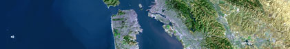
Area of Operation
|
Northern Florida Keys Reef Tract
|
|
Location map
|

|
|
Bounding Coordinates
|
31.75000
-87.75000 -78.25000
23.75000
|
|
Ports
|
LEAVE Florida City, Florida
ARRIVE Florida City, Florida
|
|
Dates
|
09/10/2007 (JD 253) to 09/21/2007 (JD 264)
|
|
Analog Materials
|
No analog holdings.
|
|
Index map

|
|
|
Information Specialist
|
|
|
Crew
|
|
Monica Palaseanu-Lovejoy
|
|
Phil Thompson
|
|
Keith Ludwig
|
|
Jerry Butcher
|
|
Emily Klipp
|
|
|
Purpose
|
|
Obtain high-resolution geo-located imagery and submerged topography to
|
|
understand benthic habitat and structure
|
|
|
Information to be Derived
|
|
Geo-located imagery, submerged topography
|
|
|
Summary
|
|
Boat based acoustic data and imagery
|
|
|
Notes
|
|
USGS Along Track Reef Imaging System (ATRIS)
|
|
|
Got Help?
|
For 07AFL01, we would appreciate any information on -- analog materials, contract, days at sea, dive count, equipment used, funding, kms of navigation, national plan, NGDC Info, owner, project number, publications, scanned materials, seismic description, station count, station description, submersible, tabulated info.
|
|