|
|
|
Metadata
|
|
ID
|
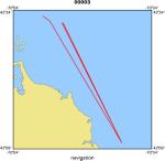
00003
|
|
Also Known As
|
00003
HANA00003
H-3-00-MY
|
|
Abstract
|
United States Geological Survey, Woods Hole, Massachusetts.
Chief Scientist: Mike Bothner. Data (navigation) of field
activity 00003 (H-3-00-MY) in Massachusetts Bay from
05/09/2000 to 05/10/2000
|
|
Organization
|
United States Geological Survey, Woods Hole, Massachusetts
|
|
Project/Theme
|
Mass Bay Long-term Monitoring
|
|
Chief Scientist
|
Mike Bothner
|
|
Platform
|
Marcus Hanna
|
|
Owner
|
US Coast Guard, Portland, ME
|
|
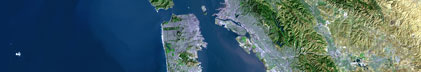
Area of Operation
|
Massachusetts Bay
|
|
Location map
|
|
|
Bounding Coordinates
|
42.37810
-70.78479 -70.63990
42.16280
|
|
Ports
|
leave Boston, MA
arrive Boston, MA
|
|
Dates
|
05/09/2000 (JD 130) to 05/10/2000 (JD 131)
|
|
Analog Materials
|
No analog holdings.
|
|
Index map

|
|
|
Information Specialist
|
|
Michael Bothner; edited by Jessica Cote (mbothner@usgs.gov)
|
|
|
Crew
|
|
Mike Bothner
|
Chief Scientist, USGS Woods Hole
|
|
Richard Foy
|
Captain, USCG, Boston, MA
|
|
Jonathan Borden
|
Unspecified, USGS Woods Hole
|
|
Dann Blackwood
|
Unspecified, USGS Woods Hole
|
|
Mike Casso
|
Unspecified, USGS Woods Hole
|
|
Jessica Cote
|
Unspecified, USGS Woods Hole
|
|
Roger Hubbell
|
Unspecified, USGS Woods Hole
|
|
Harris
|
Unspecified, USGS Woods Hole
|
|
Marinna Martini
|
Unspecified, USGS Woods Hole
|
|
Rick Rendigs
|
Unspecified, USGS Woods Hole
|
|
Sunita Shah
|
Unspecified, USGS Woods Hole
|
|
Begley
|
Unspecified, USGS Woods Hole
|
|
Joe Newell
|
Mob-demob, USGS Woods Hole
|
|
Bob Barton
|
Mob-demob, USGS Woods Hole
|
|
Joanne Goudreau
|
Unspecified, WHOI
|
|
|
Equipment Used
|
|
|
Purpose
|
|
Moorings 611-5, 624-7, sample
|
|
|
Information to be Derived
|
|
Times series data;Samples and Chemical Analysis;Grain size
|
|
analysis;Suspended Sediment Concentrations
|
|
|
Summary
|
|
Moorings deployed: 4(#624,625,626,627 all recovered #00004 MARCUS
|
|
HANNA Sep 26-28, 2000.) Moorings recovered: 5(#611,612,613,614 all
|
|
deployed #00002 MARCUS HANNA Feb 15-16, 2000; and #615 deployed #00048
|
|
CHRISTOPHER ANDREWS Mar 28-29, 2000.)
|
|
|
Notes
|
|
|
Project Number
|
|
|
Funding
|
|
USGS - MWRA Joint Funding Agreement
|
|
|
Publications
|
|
Cruise Report exists at Woods Hole
|
|
|
Got Help?
|
For 00003, we would appreciate any information on -- activity type, analog materials, contract, days at sea, dive count, kms of navigation, national plan, NGDC Info, scanned materials, seismic description, station count, station description, submersible, tabulated info.
|
|