|
|
|
Metadata
|
|
ID
|
H-1-98-HW
|
|
Abstract
|
United States Geological Survey, Menlo Park, California.
Chief Scientists: Monty Hampton, Mike Torresan. Photography
and Video data (digitalcamera, underwatertelevision,
underwatercamera, integratednavigation) of field activity
H-1-98-HW in Kailua Bay, Hawaii from 03/10/1998 to
03/13/1998
|
|
Organization
|
United States Geological Survey, Menlo Park, California
|
|
Project/Theme
|
Hawaii Sand Resources
|
|
National Plan
|
Natural Resources
|
|
Chief Scientist
|
Monty Hampton
Mike Torresan
|
|
Activity Type
|
Photography and Video
|
|
Platform
|
Hapa
|
|
Area of Operation
|
Kailua Bay, Hawaii
|
|
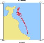
Location map
|
|
|
Bounding Coordinates
|
21.45434
-157.72098 -157.66125
21.31880
|
|
Dates
|
03/10/1998 (JD 069) to 03/13/1998 (JD 072)
|
|
Analog Materials
|
list
|
|
Index map

|
|
|
Crew
|
|
Monty Hampton
|
Chief Scientist, USGS Western Region
|
|
Mike Torresan
|
Chief Scientist, USGS Western Region
|
|
|
Equipment Used
|
|
digitalcamera
|
|
underwatertelevision
|
|
underwatercamera
|
|
integratednavigation
|
|
|
Purpose
|
|
Inspect the nature of the seafloor on the reef front in Kailua Bay
|
|
|
Information to be Derived
|
|
Nature of seafloor sediment, bedforms, biology
|
|
|
Summary
|
|
Ran 14 lines, 12 perpendicular to shore and 2 parallel to shore.
|
|
|
Notes
|
|
Hawaii sand resources - Kailua Bay
|
|
|
Got Help?
|
For H-1-98-HW, we would appreciate any information on -- contract, days at sea, dive count, funding, information specialist, kms of navigation, NGDC Info, owner, ports, project number, publications, scanned materials, seismic description, station count, station description, submersible, tabulated info.
|
|