|
|
|
Metadata
|
|
ID
|
G-18-71-NP
|
|
Also Known As
|
DSDP18GC
|
|
Abstract
|
Chief Scientist: Roland Von Huene. Geophysical data
(transitsatellite, 12khz, magnetics, airgun, bathymetry) of
field activity G-18-71-NP in Northern Pacific from 05/29/1971
to 07/18/1971
|
|
Project/Theme
|
Deep Sea Drilling Project
|
|
Chief Scientist
|
Roland Von Huene
|
|
Activity Type
|
Geophysical
|
|
Platform
|
Glomar Challenger
|
|
Area of Operation
|
Northern Pacific
|
|
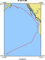
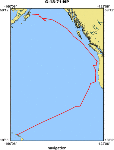
Location map
|
|
|
Bounding Coordinates
|
58.00000
-158.00000 -124.00000
21.00000
|
|
Ports
|
leave Honolulu, Hawaii
arrive Kodiak, Alaska
|
|
Dates
|
05/29/1971 (JD 149) to 07/18/1971 (JD 199)
|
|
Analog Materials
|
list
|
|
Index map
|
|
|
Crew
|
|
Roland Von Huene
|
Chief Scientist, USGS Western Region
|
|
|
Equipment Used
|
|
transitsatellite
|
|
12khz
|
|
magnetics
|
|
airgun
|
|
bathymetry
|
|
|
Notes
|
|
Scripps Institution of Oceanography
|
|
|
NGDC Overview
|
|
! Converted to time format with year at start.
|
|
!
|
|
DATA COLLECTION OVERVIEW (use NGDC GEODAS CD to retrieve data)
|
|
|
|
MCG Data Collection ID --- G1871NP
|
|
Institution Data Collection ID --- DSDP18GC
|
|
NGDC ID --- 15050016
|
|
Funding --- (unspecified)
|
|
Project, Cruise & Leg --- DEEPSEA DRILL.LG 18
|
|
Study region --- +58.00000,+21.00000,-158.00000,-124.00000
|
|
Chief Scientist(s) --- KULM L.,VON HUENE R.
|
|
Name of vessel --- D/V GLOMAR CHALLENGER (surface ship)
|
|
Date field data collection started --- 05/29/71 HONOLULU,HAWAII
|
|
Date field data collection ended --- 07/18/71 KODIAK,ALASKA
|
|
Parameters surveyed ---
|
|
Bathymetry: surveyed, contained in data file
|
|
Magnetics: surveyed, contained in data file
|
|
Gravity: not surveyed
|
|
High-resolution seismics: not surveyed
|
|
Deep penetration seismics: surveyed, but not contained in data file
|
|
Format --- (I1,A8,F5.2,4I2,F5.3,F8.5,F9.5,I1,F6.4,F6.1,I2,i1,3F6.1,I1,F5.1,F6.0,F7.1,F6.1,F5.1,A8,4I1)
|
|
Date of data input to NGDC --- 11/22/79
|
|
Contributing institution --- SCRIPPS INSTITUTION OF OCEANOGRAPHY
|
|
Country --- USA
|
|
|
|
Navigation instrumentation --- SATNAV,MANUAL ENTRY GYRO AND SPD CHANGES
|
|
Position determination method --- LINEAR INTERP.BETWEEN ADJACENT FIXES
|
|
|
|
Bathymetry instrumentation --- 12KHZ/GIFFT RECORDER/WIDE(60DEG)BEAM
|
|
Additional forms of bathymetric data --- ANAL.RECORDS,CARDS,35MMFILM
|
|
General rate of bathymetry in file --- 5.0 minutes
|
|
General collection rate of bathymetry --- 1SECONDSWEEP
|
|
Assumed sound velocity --- 1463.0 m/sec
|
|
Bathymetric datum code --- No correction applied (sea level)
|
|
Bathmetry interpolation scheme --- 5 MINUTE INTERVAL
|
|
|
|
Magnetics instrumentation --- VARIAN MFD PROTON PRECESSION MOD 4970
|
|
Additional forms of magnetics data --- ANAL.RECORDS,CARDS,35MMFILM
|
|
General rate of magnetics in file --- 5.0 minutes
|
|
General collection rate of magnetics --- 6 seconds
|
|
Magnetic sensor tow distance --- (unspecified)
|
|
Magnetic sensor depth --- (unspecified)
|
|
Two sensor horizontal separation --- (unspecified)
|
|
Residual magnetics reference field --- IGRF-65
|
|
Method of applying residual field --- LIN.INTERP.AT 30DEG C/C OR 500MI ALONG TRACK
|
|
|
|
Seismic instrumentation --- 20TO300CU.IN.AIRGUN,10-300HZ,EDO PSR REC
|
|
Formats of seismic data --- ANAL.RECORDS,35MM MICROFILM
|
|
|
|
Notes ---
|
|
*TIME*NAV AND RECORDS ORIGINALLY IN LOCAL TZ. DIGITIZED DATA CONVERTED TO GMT.
|
|
|
Publications
|
|
Kulm, La Verne D., Prince, Roger A., and Snavely, Parke D., Jr., 1973, Appendix I, Part A;
|
|
Site survey of the northern Oregon continental margin and Astoria Fan, in Musich, Lillian F.,
|
|
and Weser, Oscar E., eds., Initial reports of the Deep Sea Drilling Project, covering Leg 18
|
|
of the cruises of the drilling vessel Glomar Challenger, Honolulu, Hawaii to Kodiak, Alaska
|
May-July 1971: Initial Reports of the Deep Sea Drilling Project, v. 18, p. 979-987.
|
|
|
Core Data from the Deep Sea Drilling Project, Leg 18:
|
|
http://www.ngdc.noaa.gov/mgg/geology/dsdp/data/18/leg18.htm
|
|
|
Got Help?
|
For G-18-71-NP, we would appreciate any information on -- contract, days at sea, dive count, funding, information specialist, information to be derived, kms of navigation, national plan, organization, owner, project number, purpose, scanned materials, seismic description, station count, station description, submersible, summary, tabulated info.
|
|