SURFRAD Network: Boulder, CO
|
|
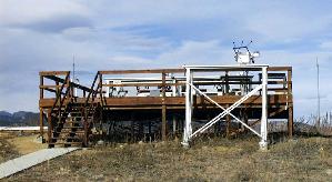
Latitude: 40.13 degrees North Longitude: 105.24 degrees West Elevation: 1689 meters Time Zone: Local Time + 7 hours = UTC Installed: July 1995 The Boulder SURFRAD instruments are located on the deck at SRRB's Table Mountain Test Facility, located 8 miles north of Boulder. These instruments are part of a larger set maintained at this location and used for annual intercomparisons and other research. |
Please click here to download SURFRAD data from the Boulder site.
Or click here to return to SURFRAD Sites Page.