
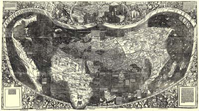
The first and only known copy of a 1507 map to bear the name "America" has been added to the Library's map collection. Compiled by cartographer Martin Waldseemüller, the map is also the first to depict a separate Western Hemisphere and the first to depict the Pacific Ocean as a separate body of water.
The Library has reached an agreement with Prince Johannes Waldburg-Wolfegg to purchase the map, printed from woodcuts, which has been called "America's birth certificate."
The map was housed for more than 350 years in the 16th century castle belonging to the prince's family at Wolfegg in southern Germany. In pristine condition, the map originally belonged to Johann Schöner (1477-1557), a Nuremberg astronomer-geographer. Long thought lost, the 1507 treasure generated great excitement when it was rediscovered in Mr. Waldburg-Wolfegg's castle in 1901.
The government of Germany and the German state of Baden-Württemberg granted an export license for the map, which is registered in the German comprehensive list of valuable national cultural property, so that it could be acquired by the Library of Congress.
The purchase price of the map is $10 million. Under the agreement between the Library and Mr. Waldburg-Wolfegg, the Library has made an initial down payment of $500,000. This payment came from fiscal 2001 appropriated funds, and the balance will be paid as funds become available. The Library is seeking donations from private sources. (In its report making supplemental appropriations for fiscal 2001, the House Appropriations Committee endorsed the Library's efforts to acquire the Waldseemüller map, House Report 107-102, June 20, 2001.)
Also, under the terms of the agreement, the map or a facsimile will be on permanent display in the Thomas Jefferson Building.
The Librarian said, "This map, giving our hemisphere its name for the first time, will be the crown jewel of the Library's already unparalleled collection of maps and atlases. The purchase will mark the culmination of an effort that has extended over many decades to bring this unique historical document to America where it can be on display in the nation's library for all to see. The Library of Congress is grateful to Prince Johannes Waldburg-Wolfegg and to the governments of the Federal Republic of Germany and the state of Baden-Württemberg, which have made this acquisition possible."
This 1507 map grew out of a massive project in St. Dié, France, in the early years of the 16th century to update geographic knowledge flowing out of the new discoveries of the late 15th and early 16th centuries. Martin Waldseemüller's large world map was the most exciting product of that research effort. He included on the map data gathered by Amerigo Vespucci during his voyages of 1501-1502 to the New World. Waldseemüller named the new lands "America" on his 1507 map in the mistaken belief that it was Vespucci and not Christopher Columbus who had discovered them. An edition of 1,000 copies of the large wood-cut print was reportedly printed and sold. Thus the name "America" given to the new lands by Waldsemüller endured, and his 1507 world map has come to be known as "America's birth certificate."
Waldseemüller's map supported Amerigo Vespucci's revolutionary concept of the New World as a separate continent, which, until then, was unknown to the Europeans. The map reflected a huge leap forward in knowledge, recognizing the newly found American land mass and forever changing mankind's understanding and perception of the world itself.
The map is the earliest multisheet printed wall map, made up of 12 sheets, each measuring 16 by 2314 inches, resulting in an overall map that measures 4.5 feet by 8 feet, or a total of 36 square feet. The map is in mint condition and is an exceptionally fine example of printing technology at the onset of the Renaissance.
The Library has the largest and most comprehensive collection of maps and atlases in the world, some 4.8 million cartographic items that date from the 14th century to the present time. The Library's map collections contain coverage for every country and subject and include the works of all the famous map makers throughout history—Ptolemy, Waldseemüller, Mercator, Ortelius and Blaeu. With its unparalleled collection related to the mapping of America, its strong holdings on the history of early printed cartography and its strength for the period of European discovery and exploration, the Library is the logical repository for preserving, studying, and displaying this unique 1507 world map by Martin Waldseemüller. The map will also be scanned and mounted on the Library's prize-winning Web site at www.loc.gov.