|
|
|
Metadata
|
|
ID
|
F-4-88-HW
|
|
Abstract
|
Chief Scientists: Bill Normark, Robin Holcomb. Geophysical
data (3dot5khz, 10khz, tempsalinometer, magnetics, gravity,
2channelairgun, Gloriasidescan, expendablebatthermograph,
GPS, integratednavigation, RhoRho, transitsatellite) of field
activity F-4-88-HW in Hawaii from 03/17/1988 to 04/05/1988
|
|
Project/Theme
|
Geological Long-Range Inclined Asdic (GLORIA)
|
|
Chief Scientist
|
Bill Normark
Robin Holcomb
|
|
Activity Type
|
Geophysical
|
|
Platform
|
Farnella
|
|
Area of Operation
|
Hawaii
|
|
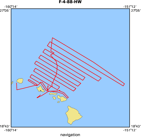
Location map
|

|
|
Bounding Coordinates
|
25.07503
-159.82198 -151.60419
20.82722
|
|
Ports
|
CAST OFF LINES, HONOLULU
ARRIVE HONOLULU, HA
|
|
Dates
|
03/17/1988 (JD 077) to 04/05/1988 (JD 096)
|
|
Analog Materials
|
list
|
|
Index map
|
|
|
Crew
|
|
Bill Normark
|
Chief Scientist, USGS Western Region
|
|
Robin Holcomb
|
Chief Scientist, USGS Western Region
|
|
|
Equipment Used
|
|
3dot5khz
|
|
10khz
|
|
tempsalinometer
|
|
magnetics
|
|
gravity
|
|
2channelairgun
|
|
Gloriasidescan
|
|
expendablebatthermograph
|
|
GPS
|
|
integratednavigation
|
|
RhoRho
|
|
transitsatellite
|
|
|
Notes
|
|
|
Publications
|
|
Normark, William R., Holcomb, Robin T., Searle, Roger C., Somers, Michael L., and
|
|
Gutmacher, Christina E., 1989, Cruise report; Hawaiian GLORIA legs 3 and 4, F3-88-HW
|
and F4-88-HW: U.S. Geological Survey Open-File Report 89-0213, 49 p.
|
|
|
Normark, W.R., Moore, J.G., Holcomb, R.T., Denlinger, R.P., Searle, R.C.,
|
|
Wilson, J.B., and Lipman, P.W., 1988, Humongous submarine slides off the Hawaiian Ridge:
|
Geological Society of America Abstracts with Programs, v. 20, no. 7, p. 127-128.
|
|
|
Holcomb, R.T., Holmes, Mark L., Lipman, P.W., Torresan, M.A., Normark, W.R., Clague,
|
|
David A., Moore, J.G., and Searle, R.C., 1988, Cenozoic submarine volcanism surrounding
|
|
the Hawaiian Islands: Geological Society of America Abstracts with Programs, v. 20,
|
no. 7, p. 128.
|
|
|
Holcomb, R.T., Holmes, M.L., Denlinger, R.P., Searle, R.C., and Normark, William R.,
|
|
1988, Submarine North Hawaiian Arch volcanic field: American Geophysical Union Eos,
|
Transactions, v. 69, no. 44, p. 1445.
|
|
|
Searle, R.C., Holcomb, R.T., Holmes, M.L., Torresan, Michael E., and Shor, A., 1988,
|
|
Counterclockwise Cretaceous spreading direction change in the Molokai fracture zone
|
near Hawaii: American Geophysical Union Eos, Transactions, v. 69, no. 44, p. 1445.
|
|
|
Torresan, M.E., Normark, W.R., Shor, A.N., and Moore, J.G., 1998, Classification of submarine
|
|
failures surrounding the Hawaiian Islands: American Geophysical Union Eos, Transactions, v. 69,
|
no. 44, p. 1508.
|
|
|
Moore, J.G., Clague, D.A., Holcomb, R.T., Lipman, P.W., Normark, W.R., and Torresan, M.E.,
|
|
1989, Prodigious submarine landslides on the Hawaiian Ridge: Journal of Geophysical Research,
|
B, Solid Earth and Planets, v. 94, no. 12, p. 17,465-17,484.
|
|
|
Moore, James G., and Normark, W.R., 1990, Significance of major landslides on the Hawaiian
|
Ridge: American Association of Petroleum Geologists Bulletin, v. 74, no. 6, p. 991-992.
|
|
|
Kayen, R.E., Torresan, M.E., Dadisman, S.V., Clague, D.A., Drake, D.E., Gutmacher,
|
|
C.E., Hampton, M.A., Marlow, M.S., Moore, J.G., Normark, W.R., Pickthorn, L.G., Shor, S.,
|
|
Denlinger, Roger P., Holcomb, Robin T., Holmes, Mark L., Lipman, P.W., Belderson, R.H.,
|
|
Jacobs, C., Searle, Roger C., Wilson, J.B., and Rothwell, R.G., 1990, GLORIA side-scan
|
|
sonar imagery of the Hawaiian Islands exclusive economic zone: American Geophysical
|
Union Eos, Transactions, v. 71, no. 43, p. 1580.
|
|
|
Binard, N., Moore, J.G., Normark, W.R., and Holcomb, R.T., 1993, Comparison of features
|
|
identified by swath-sonar mapping (GLORIA) and their 3.5 kHz echo-sounding features on
|
|
the Hawaiian Ridge: American Geophysical Union Eos, Transactions, v. 74, no. 43, Supplement,
|
p. 342.
|
|
|
Got Help?
|
For F-4-88-HW, we would appreciate any information on -- contract, days at sea, dive count, funding, information specialist, information to be derived, kms of navigation, national plan, NGDC Info, organization, owner, project number, purpose, scanned materials, seismic description, station count, station description, submersible, summary, tabulated info.
|
|


