
List of Special Collections
LEONARD N. ABRAMS GIFT (2 items). Hand-fabricated relief map of Soviet Union and prototype terrestrial globe.
ALGEMEEN RIJKSARCHIEF COLLECTION (1,519 microfiche). Maps and drawings from the Dutch Colonial Archives in The Hague.
AMERICAN AUTOMOBILE ASSOCIATION COLLECTION (64 items). Printing plates illustrating the scribe printing technique.
AMERICAN COLONIZATION SOCIETY COLLECTION (22 folders). Maps of nineteenth-century Liberia by members of the American Colonization Society.
AMERICAN CONGRESS ON SURVEYING AND MAPPING (ACSM) AWARD MAPS (400 items). Maps submitted to the annual map design competition sponsored by the American Congress on Surveying and Mapping, 1975–1990.
AMERICAN MAP COLLECTION (167 items). Rare maps of North America printed between 1750 and 1790.
ASSOCIATION OF AMERICAN RAILROADS LIBRARY COLLECTION (91 folders). Printed railroad and transportation maps.
ATLANTIC NEPTUNE COLLECTION (1,369 items). Printed navigational charts of American coastal waters and harbors by Joseph Frederick Wallet Des Barres, 1774–1794.
ATLAS DUST COVERS (125 items). Dust covers from atlases, 1834–present.
NATHANIEL PRENTISS BANKS COLLECTION (22 items). Civil War maps relating to operations conducted by General Banks, Commander of the Department of the Gulf.
JOHN BARRETT COLLECTION (85 items). Maps of Latin American and Asia acquired by the American diplomat and director of the Pan American Union, 1894–1920.
J. NEILSON BARRY COLLECTION (138 items dispersed in the collections). Manuscript maps and tracings prepared by Barry relating to his study of the exploration of the Pacific northwest.
CLARA BARTON PAPERS (36 items). Maps of Europe and the United States collected by Barton, 1877–1903.
H. BENNETT COLLECTION (1,000 items). Fire insurance maps of small towns in Iowa, 1890–1910.
ANDREW H. BENTON-HERSCHEL V. JONES COLLECTION (4,706 items dispersed in the collections). Maps, atlas sheets, printed title pages, time lines, topographic profiles, and fortification plans, 1541–1915.
JOHN BIGELOW COLLECTION (359 items dispersed in the collections). Atlases, manuscript tracings, photocopies, and printed maps of the Columbian discoveries and the Isthmuses of Panama and Suez.
WILLIAM BINGHAM ESTATE MAPS (23 items). Manuscript land ownership atlases and maps of property in Maine, New York, and Pennsylvania, 1790s–1872.
TASKER HOWARD BLISS PAPERS (179 items). Maps pertaining to World War I and the Paris Peace Conference.
BRAILLE MAPS (130 items dispersed in the division's collections). Examples of maps devised for the blind and visually handicapped, 1936–1985.
BRITTLE BOOK MAPS COLLECTION (680 folders). Printed maps removed from books and serials from the general collections.
CARTOON MAPS COLLECTION (20 items). Manuscript drawings prepared for the Chicago Tribune, Saturday Evening Post, Time, and Liberty, 1928–1940s.
CLOTH MAP COLLECTION (400 items). Maps printed or photoreproduced on various fibers such as silk and tissue, 1626–1987.
COMMERCIAL DECAL COMPANY, INCORPORATED (192 folders). Maps printed for the U.S. Army Map Service, 1943–1945.
COPELAND RAILROAD SURVEYS COLLECTION (364 items). Maps and timetables for railroads in the United States showing freight traffic density, 1921–1953.
COPYRIGHT MAP TITLES COLLECTION (600 items). Map titles deposited with U.S. District Courts, 1790–1896.
ROBERT CROZIER COLLECTION (35 items). Maps, photomaps, and aerial photographs prepared by the 654th Engineering Topographical Battalion in France and Germany, 1944–1945.
THE CUMBERLAND MAP COLLECTION (666 microfiche). Military campaign maps from the Duke of Cumberland archives, eighteenth–nineteenth centuries.
WILLIAM MORRIS DAVIS DRAWINGS (71 items). Manuscript physiographic sketches and block diagrams illustrating the cycle of erosion, 1930s.

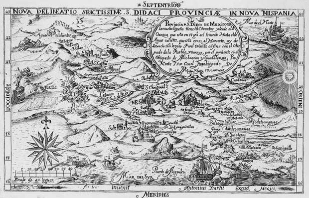 One of the earliest maps published in the New World was engraved on
copper by Antonio Ysarti in Mexico City and printed by Juan de
Ribero
in 1682. Showing the Province of San Diego in New Spain, the
engraving appeared in Balthassar de Medina's Chronica de la Santa
Provincia de San Diego de Mexico. The Geography and Map Division
holds both the original engraved copperplate and an impression taken
from the plate. (Printing Technology Collection)
One of the earliest maps published in the New World was engraved on
copper by Antonio Ysarti in Mexico City and printed by Juan de
Ribero
in 1682. Showing the Province of San Diego in New Spain, the
engraving appeared in Balthassar de Medina's Chronica de la Santa
Provincia de San Diego de Mexico. The Geography and Map Division
holds both the original engraved copperplate and an impression taken
from the plate. (Printing Technology Collection)
JOHN DISTURNELL COLLECTION (27 maps). Printed and photocopy maps of twenty-four editions of Disturnell's map of Mexico, 1826–1858.
EARTH OBSERVATION SATELLITE COMPANY (EOSAT) COLLECTION (120 items). Large format Landsat photographic images of selected features of the Earth, 1980s.
MELVILLE EASTHAM COLLECTION (444 items). Rare atlases and maps printed in Europe, 1571–circa 1850.
ENVIRONMENTAL SYSTEMS RESEARCH INSTITUTE, INCORPORATED (ESRI) COLLECTION (2,000 items). Innovative computer-generated maps exhibited at the annual esri Users' Conference from 1988–1993.
ENVIRONMENTAL SYSTEMS RESEARCH INSTITUTE, INCORPORATED (ESRI) MAP FILES (19 computer disks). Electronic files containing cartographic and statistical data for United States and world.
WILLIAM FADEN COLLECTION (101 items). Manuscript maps and plans of the French and Indian War and the American Revolution assembled by Faden, geographer to King George III, 1750s–1780s.
ETHEL M. FAIR COLLECTION (879 items). Pictorial maps from magazines, newspapers, and commercial printers, twentieth century.
MILLARD FILLMORE COLLECTION (247 items). Printed and manuscript maps of the United States and Europe collected by President Fillmore.
PETER FORCE COLLECTION (768 items). Manuscript and rare printed maps relating chiefly to the French and Indian War, the American Revolution, and the District of Columbia, 1685–1842.
THADDEUS M. FOWLER COLLECTION (224 items dispersed in the collections). Panoramic maps of American cities prepared by Fowler, 1881–1922.
GAMES AND PUZZLES (110 items). Representative examples of maps designed to serve as games and educational aids, 1822–1980s.
JEREMY FRANCIS GILMAN COLLECTION (75 items dispersed in collection). Photostatic copies of Confederate Civil War maps from originals at the U.S. Military Academy at West Point, Virginia Historical Society, and College of William and Mary.
GLOBE COLLECTION (450 items dispersed in collection). Original and facsimile terrestrial and celestial globes and globe gores, 1543–1990s.
CHARLES E. GOAD COMPANY COLLECTION (3,900 items). Fire insurance maps for 1,300 towns and cities in Canada, 1891–1973.
THE H. M. GOUSHA COMPANY COLLECTION (30 items). Painted zinc map plates created by Hal Shelton for the Jeppesen Company, 1950s–1960s.
JANET GREEN COLLECTION (636 items). Atlases, atlas title pages, globes, reference books.
GENERAL PETER H. HAGNER COLLECTION (40 items dispersed in the collections). Maps and sketches relating to Mexico, 1771–1840s.
RICHARD EDES HARRISON DRAWINGS (243 items). Manuscript sketch maps and final drawings prepared by Harrison for Fortune, Time, Life, and major map publishers, 1930s–1970s.
HENRY HARRISSE COLLECTION (615 items). Manuscript charts of the exploration of North America, 1606–1650, and Harrisse's study collection of facsimiles relating to the exploration of America.
KARL M. HAUSHOFER COLLECTION (21 maps). Printed topographic maps of Germany and Austria collected by Haushofer, a leading exponent of German geopolitics, 1930s.
HAUSLAB-LIECHTENSTEIN COLLECTION (10,000 items). Manuscript and printed military, topographic, and thematic maps assembled by the Austrian cartographer Franz Ritter von Hauslab and later acquired by Prince Johann II of Liechtenstein, nineteenth century.
EDWARD EVERETT HAYDEN AND FAMILY PAPERS (85 items). Maps and charts relating to Hayden's naval service as a marine meteorologist, 1880s–1920.
SAMUEL P. HEINTZELMANN PAPERS (20 items). Manuscript and printed maps relating to the Civil War and American southwest, 1839–1865.
ERNEST HEXAMER COLLECTION (5,000 items). Fire insurance maps of Philadelphia, 1857–1916.
JOHN HILLS COLLECTION (20 maps). Manuscript maps prepared for Sir Henry Clinton by Hills relating to British military operations in New Jersey, 1778–1781.
GENERAL JOHN L. HINES COLLECTION (187 maps). Annotated maps of American military activities in France during World War I.
JEDEDIAH HOTCHKISS MAPS AND FIELD NOTES (600 items). Prepared by the Confederate surveyor during the Civil War.
RICHARD HOWE COLLECTION (72 items). Nautical charts used by Adm. Lord Richard Howe, Commander in Chief of British Fleet, 1750s–1770s.
ARTHUR W. HUMMEL COLLECTION (85 items). Scrolls, wall maps, and atlases of China donated by Andrew W. Mellon and Hummel, Ming period (1368–1644)–1912.
ANDREW JACKSON COLLECTION (11 items). Manuscript maps associated with General Jackson's campaigns during the War of 1812.
JAPANESE ARMY ROUTE MAPS (397 items). Manuscript route maps of Korea and China prepared by Japanese military engineers, 1878–1880s.
THOMAS JEFFERSON COLLECTION (30 items). Reproductions of maps, field notes, and plans from the Papers of Thomas Jefferson, 1746–1825.
JOHN JOHNSON MAPS AND NOTEBOOKS (4 items). U.S.-Canadian boundary survey, 1817.
GEORGE KENNAN PAPERS (13 items). Printed maps of Russia, 1750–1940s.
JOHANN GEORG KOHL DRAWINGS (575 items). Manuscript copies by Kohl during the 1850s of maps in European collections relating to the discovery and exploration of North America.
MOKUSSI KUWAHARA LIBRARY (163 items dispersed in the collections). Printed and manuscript maps of Suruga Province, Japan, collected by Kuwahara for history of province.
JONATHAN T. LANMAN slide collection (650 items). 35mm color slides of maps relating to European exploration and discovery and East Asia.
ROBERT LANSING COLLECTION (10 items). Atlases relating to the Alaska Boundary Tribune and North Atlantic Fishery Arbitration, 1895–1909.
WALDO G. LELAND collection. Inventory of maps of North America found in the Bibliotheque Nationale and the archives of the Service Hydrographique de la Marine, Paris.
LEWIS AND CLARK COLLECTION (20 items). Manuscript maps associated with William Clark, 1796–1832.
WOODBURY LOWERY COLLECTION (300 items). Study collection of original and facsimile maps relating to early Spanish exploration and settlement in North America.
MAGELLAN GEOGRAPHIX DATABASE (56 computer disks). Electronic map files providing worldwide coverage of selected places.
MAGGS CHART COLLECTION (369 items dispersed in the collection). Manuscript nautical charts, chiefly of South America, prepared by students at the Naval Academy in Cadiz, Spain, 1729–1824.
MATTHEW FONTAINE MAURY COLLECTION (160 items). Published wind and current charts by Maury, 1848–1850s.
GEORGE B. MCCLELLAN COLLECTION (27 maps). Sketch maps and fortification plans drawn or collected by McClellan as a cadet at West Point, 1842–1846, and maps of the Virginia Military District in Ohio.
SHANNON MCCUNE COLLECTION (22 items). Scrolls, atlases, woodblocks, and fan maps of Korea and Japan, fifteenth–nineteenth centuries.
WILLIAM MCKINLEY PAPERS (11 items). Printed maps of China and the United States.
JOHN MELISH COLLECTION (35 items). Series of engraved wall maps of the United States compiled and printed by Melish, 1816–1823.
MYLON MERRIAM COLLECTION (1,150 items). Topographic maps, city plans, oblique images and panoramic views, chiefly of Switzerland, 1850–1950s.
MICROFILM COLLECTION (101 microfilm reels). Rare maps from archives, libraries, and mapping organizations in France, Great Britain, Italy, The Netherlands, Panama, Spain, and the United States, 1410–1924.
IRIS MILLER COLLECTION (600 items). Manuscript and printed maps, architectural drawings, and "charrettes" of Washington, D.C.
THEODORE MILLER DRAWINGS (4,786 items). Manuscript maps and atlases prepared by Miller for his Graphic History of the Americas and works in progress.
MINNESOTA AND DAKOTA FIRE UNDERWRITERS MAP COLLECTION (1,528 items). Fire insurance maps for small towns in Minnesota, North Dakota, and South Dakota, 1894–1970s.
MINTO COLLECTION (14 items dispersed in the collection). Manuscript maps of the Indonesian archipelago formerly in the possession of Gilbert Elliot, 1st Earl of Minto and Governor General of India, 1807–1814.
JOHN MITCHELL COLLECTION (32 maps). Various editions of Mitchell's Map of North America, 1755–1779.
NASA PRINT COLLECTION (630 items). Color photo images (8- by 10-inch) of the Earth generated from satellite sensing devices, 1972–1978.
NIERENSTEIN NATIONAL REALITY COMPANY (354 folders). Atlases, maps, and aerial photographs of American and Canadian cities and shopping centers, 1920s–1950s.
PIERRE OZANNE DRAWINGS (23 items). Maps of views of French naval engagements in the West Indies and North America by Ozanne, a marine artist with French naval forces, 1770s.
PANAMA CANAL ZONE LIBRARY-MUSEUM MAP COLLECTION (505 items). Manuscript and printed maps relating to the Panama Canal Zone, circa 1700–1967.
MURIEL H. PARRY COLLECTION (800 items). Pictorial maps, including a set of English shire maps by the noted illustrator, Ernest Clegg.
JOSEPH R. PASSONNEAU COLLECTION (26 items). Manuscript historic maps of Georgetown and Washington, D.C., by Passonneau and associates.
CHARLES OSCAR PAULLIN COLLECTION (62 portfolios). Maps relating to congressional voting patterns, 1791–1883, used in the preparation of his Historical Atlas of the United States.
ORLANDO M. POE COLLECTION (16 items). Civil War maps from the papers of General Poe.
PORTUGUESE-SPANISH BOUNDARY COMMISSION MAPS (29 items dispersed in the collections). Manuscript and photocopy surveys of the Brazil-Uruguay frontier, 1780s.
POWDER HORN COLLECTION (8 items). Powder horns with maps and views inscribed by soldiers, 1750s to 1812.
PRINTING TECHNOLOGY COLLECTION (15 items, dispersed in division's collections). Woodblocks, copperplates, lithographic stones, glass plates, and plastic separation sheets used for printing maps, 1682–1980s.
ERWIN RAISZ COLLECTION (96 items). Printed landform maps prepared by Raisz, 1939–1963.
CHARLES RASCHER COLLECTION (5,000 items). Fire insurance maps of Chicago, nineteenth century.
CHARLES RAU collection (20 items). Drawings by Rau showing cartographic techniques, 1841–1854.
REMOTE SENSING IMAGERY AND AERIAL PHOTOGRAPHY BROWSE FILE (25,000 items). Film cassettes and microfiche indexes of images of the Earth taken from satellites and aircraft, 1960s–1990s.
WALTER W. RISTOW CHRISTMAS CARD COLLECTION (500 items). Christmas cards illustrated with maps, globes, and cartographic instruments, 1940s–1980s.
ROCHAMBEAU COLLECTION (122 items). Maps and plans of military fortifications and troop positions in North America prepared for Jean Baptiste Donatien de Vimeur, compte de Rochambeau, commander of French forces, 1777–1783.
ADMIRAL JOHN RODGERS COLLECTION (92 items dispersed in the collections). Printed portolan charts of North America issued by the Spanish Dirección de Hidrografía, 1818.
 "Map of the United States with the contiguous British and Spanish
Possessions" (Philadelphia, 1816). is the first wall map of the
United States published by John Melish, the leading American map
publisher of his day. The Geography and Map Division holds twenty-one
of the twenty-five known states of this map. (John Melish Collection)
"Map of the United States with the contiguous British and Spanish
Possessions" (Philadelphia, 1816). is the first wall map of the
United States published by John Melish, the leading American map
publisher of his day. The Geography and Map Division holds twenty-one
of the twenty-five known states of this map. (John Melish Collection)
THEODORE ROOSEVELT PAPERS (9 items). Manuscript and annotated maps pertaining principally to Russo-Japanese War, 1905.
LESSING J. ROSENWALD GIFT (11 items dispersed in the collection). Rare printed maps and atlases, 1562–eighteenth century.
MARCIAN F. ROSSI COLLECTION (279 items). Vellum maps of the known world attributed to the era of Marco Polo and supporting materials.
ALBERT RUGER COLLECTION (198 items). Panoramic views of midwestern cities published by Ruger, 1860s–1870s.
RUSSIAN PALACES LIBRARY COLLECTION (170 items). Printed maps, principally of Russia, from four palace libraries in Czarist Russia, 1827–1858.
SANBORN FIRE INSURANCE COMPANY COLLECTION (700,000 items). Detailed maps of 12,000 American cities and towns, 1867–1980s.
WILLIAM TECUMSEH SHERMAN COLLECTION (205 items). Maps and atlases relating to Sherman's military campaigns during the Civil War.
GUY-HAROLD SMITH DRAWINGS (15 items dispersed in the collections). Manuscript drawings of physiographic diagrams of South America and western states, 1930s.
ALBERT SPEER MATERIALS (28 items). Maps and plans of the redevelopment of Berlin prepared for Adolf Hitler, 1933–1942.
EPHRAIM GEORGE SQUIER COLLECTION (38 maps). Manuscript and printed maps of Central America relating to canals and railroads, 1850s–1880s.
CHARLES PELOT SUMMERALL PAPERS (363 items dispersed in the collections). Personal collection of manuscript, annotated, and printed World War I battle maps of General Summerall.
HERBERT THATCHER BEQUEST (76 items dispersed in the collections). Ptolemaic atlases and manuscript tracings of maps of North America, nineteenth century.
GILBERT THOMPSON COLLECTION (134 items). Maps, photographs, and topographic views relating to western exploration, 1850s–1896.
THREE-DIMENSIONAL RAISED RELIEF MAPS (2,300 items). Three-dimensional raised relief maps and terrain models printed or painted on plaster, papier-mâché, vinyl plastic, or sponge rubber, 1879–1990s.
EDGAR TOBIN AERIAL SURVEYS COLLECTION. (240 items). Aerial photographic mosaic prints of southern states, 1953–1954.
JOSEPH MEREDITH TONER COLLECTION (32 items). Manuscript maps and tracings relating to Washington, D.C., 1790s–1880s.
TWENTY-SEVENTH INTERNATIONAL GEOGRAPHICAL CONGRESS MAP EXHIBITION (1,962 items dispersed in the collections). Atlases, maps, aerial photographs, remote sensing images, and cartography and geography books from thirty-seven countries, 1992.
UNITED KINGDOM INTER-SERVICE TOPOGRAPHICAL DEPARTMENT COLLECTION (200 volumes). Topographic intelligence reports containing maps, terrain descriptions, and aerial photographs of military sites in Europe and Southeast Asia during World War II.
U.S. CENSUS BUREAU MAPS (803 folders). Block statistics maps for standard metropolitan areas, 1980 and 1990.
U.S. CENSUS BUREAU TIGER/LINE FILES (47 computer discs). Electronic data base for 1990 decennial map of the United States.
U.S. COAST AND GEODETIC SURVEY LIBRARY (207 items). Manuscript and printed nautical charts of the Great Lakes and coastal regions of the United States, 1830–1968.
U.S. CONGRESSIONAL SERIAL SET (17,000 items). Maps published by Congress as enclosures in Congressional publications, 1817–1909.
U.S. DEFENSE MAPPING AGENCY DATA FILES (6 computer disks). Digital chart of the world.
U.S. GEOLOGICAL SURVEY DATA FILES (20 computer disks). Electronic spatial data relating to a variety of scientific programs.
U.S. GEOLOGICAL SURVEY REPORTS (13,600 folders). Geologic and hydrologic maps from scientific reports.
U.S. NATIONAL CANCER INSTITUTE MAPPING PROGRAM (16 computer disks). Electronic maps of cancer mortality by county.
U.S. OFFICE OF STRATEGIC SERVICES (OSS) MAP COLLECTION (1,300 items dispersed in the collections). General and thematic maps produced by OSS during World War II.
U.S. OFFICE OF STRATEGIC SERVICES (OSS) MICROFILM COLLECTION (101 microfilm reels). Maps from various libraries in the United States filmed during World War II.
VAULT MAP COLLECTION (3,000 items). Manuscript and printed maps maintained separately for their unique, artistic, or historical significance, sixteenth–twentieth centuries.
VELLUM CHART COLLECTION (33 items). Rare nautical atlases and charts on vellum, 1484–seventeenth century.
LANGDON WARNER COLLECTION (30 items). Manuscript maps, atlases, and fan maps of Korea and China collected by Warner, director of the first and second China expeditions of the Fogg Museum, Harvard University, Ming Dynasty–nineteenth century.
GEORGE WASHINGTON ATLAS SOURCE MATERIALS COLLECTIONS (1,308 items). Chiefly photocopies of maps and text used by Lawrence Martin in the production of the George Washington Atlas (1932).
GEORGE WASHINGTON MAPS (12 items dispersed in collection). Manuscript and published plans and plats drawn by George Washington and his associates, 1749–1793.
WASHINGTON METROPOLITAN AREA TRANSIT AUTHORITY (METRO) MAPS (33 items). Translucent maps of the Washington, D.C., metro system.
MARY J. WEBB COLLECTION (39 items). Tracings of nineteenth-century maps of Texas relating to early land grants.
HOWARD WELSH COLLECTION (29 items). Globes and maps published in the United States during the nineteenth century.
ALPHONSO WHIPPLE COLLECTION (2,000 items). Fire insurance maps of St. Louis, nineteenth century.
CAPTAIN JAMES M. WILLIS COLLECTION (15 items). Manuscript nautical charts, drawing and writing instruments, and chart case belonging to Willis, 1852–1875.
WOODROW WILSON PAPERS (8 maps). Manuscript and printed political boundary maps prepared primarily for the Paris Peace Conference, 1918–1919.
YUDIN COLLECTION (6 items). Archaeological maps and maps of gold-mining concessions in Yiniseysk District, Russia, 1858–1900.
Geography and Map Reading Room
Library of Congress Help Desk (05/06/98)