- Identification_Information:
-
- Citation:
-
- Citation_Information:
-
- Originator: U.S. Geological Survey (USGS), Coastal and Marine Geology (CMG)
- Publication_Date: 20090107
- Title:
-
Geophysical data of field activity F-6-86-HW in Hawaii from
11/05/1986 to 11/26/1986
- Publication_Information:
-
- Publisher: U.S. Geological Survey (USGS), Coastal and Marine Geology (CMG)
- Online_Linkage: <http://walrus.wr.usgs.gov/infobank/gos/f-6-86-hw.fmeta.xml>
- Online_Linkage:
-
<http://walrus.wr.usgs.gov/infobank/f/f686hw/html/f-6-86-hw.meta.html>
- Description:
-
- Abstract:
-
Chief Scientists: Bill Normark, Peter Lipman. Geophysical
data (10khz, gravity, 2channelairgun, tempsalinometer,
3dot5khz, Gloriasidescan, gradiometer,
expendablebatthermograph) of field activity F-6-86-HW in
Hawaii from 11/05/1986 to 11/26/1986,
<http://walrus.wr.usgs.gov/infobank/f/f686hw/html/f-6-86-hw.meta.html>.
- Purpose:
-
These data and information are intended for science
researchers, students from elementary through
college, policy makers, and general public.
- Supplemental_Information:
-
Equipment Used -
10khz 10 khz bathymetry
gravity
2channelairgun two-channel airgun
tempsalinometer temperature/salinity/conductance gauges
3dot5khz 3.5 khz bathymetry
Gloriasidescan
gradiometer
expendablebatthermograph
Notes -
Associated cruises:
<br>
<A HREF="<http://walrus.wr.usgs.gov/infobank/f/f586hw/html/f-5-86-hw.meta.html>">F-5-86-HW</A>
<A HREF="<http://walrus.wr.usgs.gov/infobank/f/f686hw/html/f-6-86-hw.meta.html>">F-6-86-HW</A>
<BR>
<A HREF="<http://walrus.wr.usgs.gov/infobank/f/f388hw/html/f-3-88-hw.meta.html>">F-3-88-HW</A>
<A HREF="<http://walrus.wr.usgs.gov/infobank/f/f488hw/html/f-4-88-hw.meta.html>">F-4-88-HW</A>
<A HREF="<http://walrus.wr.usgs.gov/infobank/f/f588hw/html/f-5-88-hw.meta.html>">F-5-88-HW</A>
<A HREF="<http://walrus.wr.usgs.gov/infobank/f/f688hw/html/f-6-88-hw.meta.html>">F-6-88-HW</A>
<A HREF="<http://walrus.wr.usgs.gov/infobank/f/f1088hw/html/f-10-88-hw.meta.html>">F-10-88-HW</A>
<BR>
<A HREF="<http://walrus.wr.usgs.gov/infobank/f/f1289hw/html/f-12-89-hw.meta.html>">F-12-89-HW</A>
<A HREF="<http://walrus.wr.usgs.gov/infobank/f/f1389hw/html/f-13-89-hw.meta.html>">F-13-89-HW</A>
<BR>
<A HREF="<http://walrus.wr.usgs.gov/infobank/f/f190hw/html/f-1-90-hw.meta.html>">F-1-90-HW</A>
<A HREF="<http://walrus.wr.usgs.gov/infobank/f/f290hw/html/f-2-90-hw.meta.html>">F-2-90-HW</A>
<BR>
<A HREF="<http://walrus.wr.usgs.gov/infobank/f/f691cp/html/f-6-91-cp.meta.html>">F-6-91-CP</A>
<A HREF="<http://walrus.wr.usgs.gov/infobank/f/f1091hw/html/f-10-91-hw.meta.html>">F-10-91-HW</A>
<HR>
Geological LOng-Range Inclined Asdic (GLORIA)
<A HREF="<http://kai.er.usgs.gov/gloria>" target="gl">GLORIA</A>
Publications -
Normark, William R., Lipman, Peter W., Wilson, John B., Jacobs, Colin L., Johnson, David P.,
and Gutmacher, Christina, 1987, Preliminary cruise report, Hawaiian GLORIA Leg 2, F6-86-HW,
November 1986: U.S. Geological Survey Open-File Report 87-0298, 42 p.<BR>
<HR>
Lipman, Peter W., Normark, William R., Moore, James G., Wilson, John B., and Gutmacher,
Christina E., 1988, The giant submarine Alika debris slide, Mauna Loa, Hawaii, in Tilling,
Robert I., ed., Special section on How volcanoes work; Part 2: Journal of Geophysical
Research, B, Solid Earth and Planets, v. 93, no. 5, p. 4279-4299. <BR>
<HR>
Normark, W.R., Moore, J.G., Holcomb, R.T., Denlinger, R.P., Searle, R.C.,
Wilson, J.B., and Lipman, P.W., 1988, Humongous submarine slides off the Hawaiian Ridge:
Geological Society of America Abstracts with Programs, v. 20, no. 7, p. 127-128.<BR>
<HR>
Holcomb, R.T., Holmes, Mark L., Lipman, P.W., Torresan, M.A., Normark, W.R., Clague,
David A., Moore, J.G., and Searle, R.C., 1988, Cenozoic submarine volcanism surrounding
the Hawaiian Islands: Geological Society of America Abstracts with Programs, v. 20,
no. 7, p. 128.<BR>
<HR>
Torresan, M.E., Normark, W.R., Shor, A.N., and Moore, J.G., 1998, Classification of submarine
failures surrounding the Hawaiian Islands: American Geophysical Union Eos, Transactions, v. 69,
no. 44, p. 1508.<BR>
<HR>
Moore, J.G., Clague, D.A., Holcomb, R.T., Lipman, P.W., Normark, W.R., and Torresan, M.E.,
1989, Prodigious submarine landslides on the Hawaiian Ridge: Journal of Geophysical Research,
B, Solid Earth and Planets, v. 94, no. 12, p. 17,465-17,484.<BR>
<HR>
Moore, J.G., Normark, William R., and Szabo, B.J., 1990, Reef growth and volcanism on the
submarine southwest rift zone of Mauna Loa, Hawaii: Bulletin of Volcanology, v. 52, no. 5,
p. 375-380.<BR>
<HR>
Moore, James G., and Normark, W.R., 1990, Significance of major landslides on the Hawaiian
Ridge: American Association of Petroleum Geologists Bulletin, v. 74, no. 6, p. 991-992.<BR>
<HR>
Moore, J.G., Normark, W.R., and Gutmacher, C.E., 1990, Morphology of giant submarine
debris-avalanche deposits, Mauna Loa, Hawaii: American Geophysical Union Eos, Transactions,
v. 71, no. 43, p. 1577.<BR>
<HR>
Moore, J.G., Normark, W.R., and Gutmacher, C.E., 1992, Major landslides on the
submarine flanks of Mauna Loa Volcano, Hawaii: Landslide News, v. 6, p. 13-16.<BR>
<HR>
Moore, James G., Bryan, Wilfred B., Beeson, Melvin H., and Normark, William R., 1995,
Giant blocks in the South Kona Landslide, Hawaii: Boulder, CO, Geology, v. 23, no. 2,
p. 125-128.<BR>
Similar information is available for thousands
of other USGS/CMG-related Activities.
If known, available are Activity-specific
navigation, gravity, magnetics, bathymetry,
seismic, and sampling data; track maps; and
equipment information; as well as summary
overviews, crew lists, and information
about analog materials.
If available, access to physical samples is
described in the "WR CMG Sample Distribution
Policy" at:
<http://walrus.wr.usgs.gov/infobank/programs/html/main/sample-dist-policy.html>
Primary access to the USGS/CMG Information
Bank's digital data, analog data, and
metadata is provided through...
<http://walrus.wr.usgs.gov/infobank/>
This page accomodates a variety of search
approaches (e.g., by platform, by region,
by scientist, by equipment type, etc.).
- Time_Period_of_Content:
-
- Time_Period_Information:
-
- Range_of_Dates/Times:
-
- Beginning_Date: 19861105
- Ending_Date: 19861126
- Currentness_Reference: ground condition
- Status:
-
- Progress: Complete
- Maintenance_and_Update_Frequency: As needed
- Spatial_Domain:
-
- Bounding_Coordinates:
-
- West_Bounding_Coordinate: -158.56560
- East_Bounding_Coordinate: -152.43350
- North_Bounding_Coordinate: 20.77380
- South_Bounding_Coordinate: 15.93530
- Keywords:
-
- Theme:
-
- Theme_Keyword_Thesaurus: ISO 19115 Topic Category
- Theme_Keyword: geoscientificinformation
- Theme_Keyword: oceans
- Theme:
-
- Theme_Keyword_Thesaurus: USGS CMG InfoBank
- Theme_Keyword: Marine Geology
- Theme_Keyword: Marine Geophysics
- Theme_Keyword: Marine Gravity Field
- Theme_Keyword: Marine Magnetic Field
- Theme_Keyword: Magnetic Anomalies
- Theme_Keyword: Bathymetry
- Theme_Keyword: Water Depth
- Theme_Keyword: Seafloor Topography
- Theme_Keyword: Marine Seismic
- Theme_Keyword: Marine Metering
- Theme_Keyword: Temperature / Salinity / Conductance Gauges
- Theme_Keyword: Experimental Bathymetry Thermograph
- Place:
-
- Place_Keyword_Thesaurus: USGS CMG InfoBank
- Place_Keyword: Central Pacific Ocean
- Place_Keyword: HW
- Place_Keyword: Hawaii
- Place_Keyword: Hawaii I EEZ
- Place_Keyword: North Pacific Ocean
- Place_Keyword: Northern Pacific Ocean
- Place_Keyword: USA
- Access_Constraints:
-
Physical materials are under controlled on-site access.
If available, access to physical samples is described
in the "WR CMG Sample Distribution Policy" at:
<http://walrus.wr.usgs.gov/infobank/programs/html/main/sample-dist-policy.html>
- Use_Constraints:
-
Please recognize the U.S. Geological Survey (USGS) as
the source of this information.
Physical materials are under controlled on-site access.
Some USGS information accessed through this means
may be preliminary in nature and presented without
the approval of the Director of the USGS. This
information is provided with the understanding
that it is not guaranteed to be correct or complete
and conclusions drawn from such information are
the responsibility of the user.
This information is not intended for navigational
purposes.
Any use of trade, firm, or product names is for
descriptive purposes only and does not imply
endorsement by the U.S. Government.
- Point_of_Contact:
-
- Contact_Information:
-
- Contact_Organization_Primary:
-
- Contact_Organization: U.S. Geological Survey (USGS), Coastal and Marine Geology (CMG)
- Contact_Person: Clint Steele
- Contact_Position: Data Acquisition, Processing, and Storage (DAPS) Group Leader
- Contact_Address:
-
- Address_Type: mailing and physical address
- Address: USGS, MailStop 999, 345 Middlefield Road
- City: Menlo Park
- State_or_Province: CA
- Postal_Code: 94025-3561
- Country: USA
- Contact_Voice_Telephone: (650) 329-5055
- Contact_Facsimile_Telephone: (650) 329-5190
- Contact_Electronic_Mail_Address: csteele@usgs.gov
- Browse_Graphic:
-
- Browse_Graphic_File_Name:
-
<http://walrus.wr.usgs.gov/infobank/f/f686hw/html/f-6-86-hw.nav.gif>
- Browse_Graphic_File_Description: Trackline map of F-6-86-HW
- Browse_Graphic_File_Type: GIF
- Browse_Graphic:
-
- Browse_Graphic_File_Name:
-
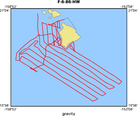
<http://walrus.wr.usgs.gov/infobank/f/f686hw/html/f-6-86-hw.grav.gif>
- Browse_Graphic_File_Description: Gravity data trackline map of F-6-86-HW
- Browse_Graphic_File_Type: GIF
- Browse_Graphic:
-
- Browse_Graphic_File_Name:
-
<http://walrus.wr.usgs.gov/infobank/f/f686hw/html/f-6-86-hw.mag.gif>
- Browse_Graphic_File_Description: Magnetics data trackline map of F-6-86-HW
- Browse_Graphic_File_Type: GIF
- Browse_Graphic:
-
- Browse_Graphic_File_Name:
-
<http://walrus.wr.usgs.gov/infobank/f/f686hw/html/f-6-86-hw.bath.gif>
- Browse_Graphic_File_Description: Bathymetry data trackline map of F-6-86-HW
- Browse_Graphic_File_Type: GIF
- Data_Set_Credit:
-
Bill Normark (Chief Scientist, USGS Western Region);
Peter Lipman (Chief Scientist, USGS Western Region);
John Cherriman (IOS);
Jim Clarke (IOS)
- Native_Data_Set_Environment: Digital, ASCII
- Cross_Reference:
-
- Citation_Information:
-
- Originator: U.S. Geological Survey (USGS), Coastal and Marine Geology (CMG)
- Publication_Date: Unknown
- Title: USGS/CMG Information Bank
- Publication_Information:
-
- Publisher: U.S. Geological Survey (USGS), Coastal and Marine Geology (CMG)
- Other_Citation_Details: Updated daily
- Online_Linkage: <http://walrus.wr.usgs.gov/infobank/>
- Other_Citation_Details:
-
Normark, William R., Lipman, Peter W., Wilson, John B., Jacobs, Colin L., Johnson, David P.,
and Gutmacher, Christina, 1987, Preliminary cruise report, Hawaiian GLORIA Leg 2, F6-86-HW,
November 1986: U.S. Geological Survey Open-File Report 87-0298, 42 p.
- Other_Citation_Details:
-
Lipman, Peter W., Normark, William R., Moore, James G., Wilson, John B., and Gutmacher,
Christina E., 1988, The giant submarine Alika debris slide, Mauna Loa, Hawaii, in Tilling,
Robert I., ed., Special section on How volcanoes work; Part 2: Journal of Geophysical
Research, B, Solid Earth and Planets, v. 93, no. 5, p. 4279-4299.
- Other_Citation_Details:
-
Normark, W.R., Moore, J.G., Holcomb, R.T., Denlinger, R.P., Searle, R.C.,
Wilson, J.B., and Lipman, P.W., 1988, Humongous submarine slides off the Hawaiian Ridge:
Geological Society of America Abstracts with Programs, v. 20, no. 7, p. 127-128.
- Other_Citation_Details:
-
Holcomb, R.T., Holmes, Mark L., Lipman, P.W., Torresan, M.A., Normark, W.R., Clague,
David A., Moore, J.G., and Searle, R.C., 1988, Cenozoic submarine volcanism surrounding
the Hawaiian Islands: Geological Society of America Abstracts with Programs, v. 20,
no. 7, p. 128.
- Other_Citation_Details:
-
Torresan, M.E., Normark, W.R., Shor, A.N., and Moore, J.G., 1998, Classification of submarine
failures surrounding the Hawaiian Islands: American Geophysical Union Eos, Transactions, v. 69,
no. 44, p. 1508.
- Other_Citation_Details:
-
Moore, J.G., Clague, D.A., Holcomb, R.T., Lipman, P.W., Normark, W.R., and Torresan, M.E.,
1989, Prodigious submarine landslides on the Hawaiian Ridge: Journal of Geophysical Research,
B, Solid Earth and Planets, v. 94, no. 12, p. 17,465-17,484.
- Other_Citation_Details:
-
Moore, J.G., Normark, William R., and Szabo, B.J., 1990, Reef growth and volcanism on the
submarine southwest rift zone of Mauna Loa, Hawaii: Bulletin of Volcanology, v. 52, no. 5,
p. 375-380.
- Other_Citation_Details:
-
Moore, James G., and Normark, W.R., 1990, Significance of major landslides on the Hawaiian
Ridge: American Association of Petroleum Geologists Bulletin, v. 74, no. 6, p. 991-992.
- Other_Citation_Details:
-
Moore, J.G., Normark, W.R., and Gutmacher, C.E., 1990, Morphology of giant submarine
debris-avalanche deposits, Mauna Loa, Hawaii: American Geophysical Union Eos, Transactions,
v. 71, no. 43, p. 1577.
- Other_Citation_Details:
-
Moore, J.G., Normark, W.R., and Gutmacher, C.E., 1992, Major landslides on the
submarine flanks of Mauna Loa Volcano, Hawaii: Landslide News, v. 6, p. 13-16.
- Other_Citation_Details:
-
Moore, James G., Bryan, Wilfred B., Beeson, Melvin H., and Normark, William R., 1995,
Giant blocks in the South Kona Landslide, Hawaii: Boulder, CO, Geology, v. 23, no. 2,
p. 125-128.
- Data_Quality_Information:
-
- Attribute_Accuracy:
-
- Attribute_Accuracy_Report: Identified as best available version.
- Logical_Consistency_Report: Unspecified
- Completeness_Report:
-
Start and end date/times of data
Navigation Data (f-6-86-hw.070)
YYYYMMDDHHMMSST    YYYYMMDDHHMMSST
198611052016000    198611260210000
YYYYMMDDHHMMSST    YYYYMMDDHHMMSST
Gravity Data (f-6-86-hw.160_070)
YYYYMMDDHHMMSST    YYYYMMDDHHMMSST
198611060343200    198611072334000
198611072340000    198611080738000
198611080755000    198611081632200
198611081641200    198611082058400
198611082126400    198611091148200
198611091154000    198611091331400
198611091341200    198611091827000
198611091834200    198611100142000
198611100149000    198611121653200
198611121710000    198611121715200
198611121729400    198611131033000
198611131039400    198611131840200
198611131852400    198611150834000
198611150839400    198611160131400
198611160149400    198611160747400
198611160814400    198611161022400
198611161050000    198611161509400
198611161517200    198611161905200
198611161918000    198611170606000
198611170612400    198611181104000
198611181111000    198611200217200
198611200236400    198611202338000
198611202343200    198611212126400
198611212135200    198611222224000
198611222229200    198611231033200
198611231040400    198611240218000
198611240232200    198611242231000
198611242236200    198611242259200
198611242310400    198611260210000
YYYYMMDDHHMMSST    YYYYMMDDHHMMSST
Magnetics Data (f-6-86-hw.241_070)
YYYYMMDDHHMMSST    YYYYMMDDHHMMSST
198611060310140    198611060310140
198611060316040    198611180023170
198611190218190    198611260148060
YYYYMMDDHHMMSST    YYYYMMDDHHMMSST
Bathymetry Data (f-6-86-hw.332_070)
YYYYMMDDHHMMSST    YYYYMMDDHHMMSST
198611052016000    198611162342000
198611162350000    198611260206000
YYYYMMDDHHMMSST    YYYYMMDDHHMMSST
Seismic Shots Data (f-6-86-hw.400_070)
YYYYMMDDHHMMSST    YYYYMMDDHHMMSST
198611060511000    198611060937500
198611061056000    198611061514500
198611061550000    198611061824500
198611061921000    198611070501000
198611070600000    198611071426500
198611071443000    198611071556500
198611071610000    198611072328500
198611072350000    198611080742200
198611080755000    198611081214100
198611081235000    198611081625500
198611081657000    198611081942200
198611082100000    198611100126100
198611100142000    198611100301500
198611100313000    198611111052500
198611111104000    198611111857000
198611111932000    198611112110500
198611112121000    198611120510500
198611120519000    198611131821300
198611131924000    198611132029500
198611132035000    198611150442500
198611150449000    198611150901500
198611150910000    198611152216500
198611152223000    198611160120500
198611160129000    198611160314500
198611160324000    198611161500500
198611161511000    198611161600000
198611161614000    198611161849000
198611161904000    198611181044500
198611181059000    198611181228500
198611181237000    198611192151500
198611192157000    198611200202500
198611200225000    198611200503500
198611200509000    198611212111500
198611212122000    198611212314500
198611212322000    198611230805500
198611230815000    198611231019500
198611231029000    198611231854200
198611240801000    198611241344000
198611241414000    198611242247500
198611242253000    198611250527500
198611250535000    198611250650500
198611250658000    198611251630500
198611251649000    198611260137500
YYYYMMDDHHMMSST    YYYYMMDDHHMMSST
- Positional_Accuracy:
-
- Horizontal_Positional_Accuracy:
-
- Horizontal_Positional_Accuracy_Report: Unspecified
- Vertical_Positional_Accuracy:
-
- Vertical_Positional_Accuracy_Report: Unspecified
- Lineage:
-
- Process_Step:
-
- Process_Description:
-
Navigation Data
Converted to time format with year at start.

02/02/87 CAROLYN DRS$DATA:[F686HW.N]F686HW.070;
DUA0:[DRS.NAV]EOTCSSP.EXE;

Input was...
02/02/87 EDM DUA0:[DATA.F686HW.N]F686HW.050;
DUA0:[DRS.EDIT]REFARN.EXE;
- Process_Date: 19960205
- Process_Contact:
-
- Contact_Information:
-
- Contact_Organization_Primary:
-
- Contact_Organization: U.S. Geological Survey (USGS), Coastal and Marine Geology (CMG)
- Contact_Person: Clint Steele
- Contact_Position: Data Acquisition, Processing, and Storage (DAPS) Group Leader
- Contact_Address:
-
- Address_Type: mailing and physical address
- Address: USGS, MailStop 999, 345 Middlefield Road
- City: Menlo Park
- State_or_Province: CA
- Postal_Code: 94025-3561
- Country: USA
- Contact_Voice_Telephone: (650) 329-5055
- Contact_Facsimile_Telephone: (650) 329-5190
- Contact_Electronic_Mail_Address: csteele@usgs.gov
- Process_Step:
-
- Process_Description:
-
Gravity Data
10/31/1998  /lion/f/f686hw/grav/f-6-86-hw.160_070
/bear/programs/edit/automerge/automerge

Input was...
Converted to time format with year at start.

04/06/87 CAROLYN DRS$DATA:[F686HW.G]F686HW.160;
DUA0:[DRS.GRV]GRAVRED.EXE;2

04/03/87 CAROLYN DRS$DATA:[F686HW.G]F686HW.140;
DUA0:[DRS.REFMT]REFORMAT.EXE;6
using last tie of F586HW for both ties
308/1920  968816.6  Meter S-53  Hilo, Hawaii
Byron Ruppel notes, "330/0000 Broken tie at Honolulu"

01/27/87 EDM DRS$DATA:[F686HW.G]F686HW.111;
DUA0:[DRS.GRV]VALIDGRAV.EXE;

02/02/87 CAROLYN DRS$DATA:[F686HW.N]F686HW.070;
DUA0:[DRS.NAV]EOTCSSP.EXE;

02/02/87 EDM DUA0:[DATA.F686HW.N]F686HW.050;
DUA0:[DRS.EDIT]REFARN.EXE;

Input was...
Converted to time format with year at start.

02/02/87 CAROLYN DRS$DATA:[F686HW.N]F686HW.070;
DUA0:[DRS.NAV]EOTCSSP.EXE;

02/02/87 EDM DUA0:[DATA.F686HW.N]F686HW.050;
DUA0:[DRS.EDIT]REFARN.EXE;

time, lat, long, time(sec) to nearest nav fix, data values
- Process_Date: 19981031
- Process_Contact:
-
- Contact_Information:
-
- Contact_Organization_Primary:
-
- Contact_Organization: U.S. Geological Survey (USGS), Coastal and Marine Geology (CMG)
- Contact_Person: Clint Steele
- Contact_Position: Data Acquisition, Processing, and Storage (DAPS) Group Leader
- Contact_Address:
-
- Address_Type: mailing and physical address
- Address: USGS, MailStop 999, 345 Middlefield Road
- City: Menlo Park
- State_or_Province: CA
- Postal_Code: 94025-3561
- Country: USA
- Contact_Voice_Telephone: (650) 329-5055
- Contact_Facsimile_Telephone: (650) 329-5190
- Contact_Electronic_Mail_Address: csteele@usgs.gov
- Process_Step:
-
- Process_Description:
-
Magnetics Data
10/31/1998  /lion/f/f686hw/mag/f-6-86-hw.241_070
/bear/programs/edit/automerge/automerge

Input was...
Converted to time format with year at start.

02/02/87 CAROLYN DRS$DATA:[F686HW.M]F686HW.241;
DUA0:[DRS.NGDC]DESPIKE.EXE;

Input was...
Converted to time format with year at start.

02/02/87 CAROLYN DRS$DATA:[F686HW.N]F686HW.070;
DUA0:[DRS.NAV]EOTCSSP.EXE;

02/02/87 EDM DUA0:[DATA.F686HW.N]F686HW.050;
DUA0:[DRS.EDIT]REFARN.EXE;

time, lat, long, time(sec) to nearest nav fix, data values
- Process_Date: 19981031
- Process_Contact:
-
- Contact_Information:
-
- Contact_Organization_Primary:
-
- Contact_Organization: U.S. Geological Survey (USGS), Coastal and Marine Geology (CMG)
- Contact_Person: Clint Steele
- Contact_Position: Data Acquisition, Processing, and Storage (DAPS) Group Leader
- Contact_Address:
-
- Address_Type: mailing and physical address
- Address: USGS, MailStop 999, 345 Middlefield Road
- City: Menlo Park
- State_or_Province: CA
- Postal_Code: 94025-3561
- Country: USA
- Contact_Voice_Telephone: (650) 329-5055
- Contact_Facsimile_Telephone: (650) 329-5190
- Contact_Electronic_Mail_Address: csteele@usgs.gov
- Process_Step:
-
- Process_Description:
-
Bathymetry Data
10/31/1998  /lion/f/f686hw/bath/f-6-86-hw.332_070
/bear/programs/edit/automerge/automerge

Input was...
Converted to time format with year at start.

05/19/87 CAROLYN DRS$DATA:[F686HW.B]F686HW.332;
DUA0:[DRS.BAT]BATRED.EXE;1
back calculating travel times from edited depth field

05/11/87 CAROLYN DRS$DATA:[F686HW.B]F686HW.331;
DUA0:[DRS.EDIT]MERGEIT.EXE;1

05/11/87 CAROLYN DRS$DATA:[F686HW.B]F686HW.330;
DUA0:[DRS.BAT]BATRED.EXE;1
back calculating travel times from depths

05/05/87 EDM DRS$DATA:[F686HW]F686HW.330;
DUA0:[DRS.EDIT]REFARN.EXE;

05/05/87 EDM DRS$DATA:[F686HW]F686HW.330;
DUA0:[DRS.EDIT]REFARN.EXE;

Input was...
Converted to time format with year at start.

02/02/87 CAROLYN DRS$DATA:[F686HW.N]F686HW.070;
DUA0:[DRS.NAV]EOTCSSP.EXE;

02/02/87 EDM DUA0:[DATA.F686HW.N]F686HW.050;
DUA0:[DRS.EDIT]REFARN.EXE;

time, lat, long, time(sec) to nearest nav fix, data values
- Process_Date: 19981031
- Process_Contact:
-
- Contact_Information:
-
- Contact_Organization_Primary:
-
- Contact_Organization: U.S. Geological Survey (USGS), Coastal and Marine Geology (CMG)
- Contact_Person: Clint Steele
- Contact_Position: Data Acquisition, Processing, and Storage (DAPS) Group Leader
- Contact_Address:
-
- Address_Type: mailing and physical address
- Address: USGS, MailStop 999, 345 Middlefield Road
- City: Menlo Park
- State_or_Province: CA
- Postal_Code: 94025-3561
- Country: USA
- Contact_Voice_Telephone: (650) 329-5055
- Contact_Facsimile_Telephone: (650) 329-5190
- Contact_Electronic_Mail_Address: csteele@usgs.gov
- Spatial_Data_Organization_Information:
-
- Indirect_Spatial_Reference: Hawaii
- Direct_Spatial_Reference_Method: Point
- Point_and_Vector_Object_Information:
-
- SDTS_Terms_Description:
-
- SDTS_Point_and_Vector_Object_Type: Point
- Spatial_Reference_Information:
-
- Horizontal_Coordinate_System_Definition:
-
- Geographic:
-
- Latitude_Resolution: 0.00001
- Longitude_Resolution: 0.00001
- Geographic_Coordinate_Units: Decimal degrees
- Vertical_Coordinate_System_Definition:
-
- Depth_System_Definition:
-
- Depth_Datum_Name: Local surface
- Depth_Resolution: 0.1
- Depth_Distance_Units: meters
- Depth_Encoding_Method: Attribute values
- Entity_and_Attribute_Information:
-
- Overview_Description:
-
- Entity_and_Attribute_Overview: Bathymetry with Time Stamp
- Entity_and_Attribute_Detail_Citation:
-
Edited bathymetry data
Mnemonic:       (Year, Day, Hour, Min, Sec, Tenths, 2WayTravelTime, UncorrDepth)
FORTRAN format: (i4.4, i3.3, 3i2.2, i1.1, t16, f7.4, t23, f7.1)
C format:       (%4.4i%3.3i3%2.2i%1.1i %7.4f %7.1f\\n)
Naming:         .330
- Overview_Description:
-
- Entity_and_Attribute_Overview: Gravity with Time Stamp
- Entity_and_Attribute_Detail_Citation:
-
Free Air Anomaly data
Mnemonic:       (Year, Day, Hour, Min, Sec, Tenths, Eotvos, ObsGrv, TheoGrv, FAA)
FORTRAN format: (i4.4, i3.3, 3i2.2, i1.1, t16, f6.1, t23, f9.1, t33, f9.1, t43, f8.1)
C format:       (%4.4i%3.3i3%2.2i%1.1i %6.1f %9.1f %9.1f %8.1f\\n)
Naming:         .160
- Overview_Description:
-
- Entity_and_Attribute_Overview: Magnetics with Time Stamp
- Entity_and_Attribute_Detail_Citation:
-
Raw gradiometer data
Mnemonic:       (Year, Day, Hour, Min, Sec, Tenths, MstObs, SlvObs)
FORTRAN format: (i4.4, i3.3, 3i2.2, i1.1, t16, f7.1, t24, f7.1)
C format:       (%4.4i%3.3i3%2.2i%1.1i %7.1f %7.1f\\n)
Naming:         .240
- Overview_Description:
-
- Entity_and_Attribute_Overview: Navigation with Time Stamp
- Entity_and_Attribute_Detail_Citation:
-
Eotvos/course/speed/distance data
Mnemonic:       (Year, Day, Hour, Min, Sec, Tenths, Lat, Long, Eotvos, Course, Speed, Distance)
FORTRAN format: (i4.4, i3.3, 3i2.2, i1.1, t16, f9.5, t26, f10.5, t37, f8.2, t46, f6.2, t53, f6.2, t60, f7.2)
C format:       (%4.4i%3.3i3%2.2i%1.1i %9.5f %10.5f %8.2f %6.2f %6.2f %7.2f\\n)
Naming:         .070
- Overview_Description:
-
- Entity_and_Attribute_Overview: Seismic Shots with Time Stamp
- Entity_and_Attribute_Detail_Citation:
-
Raw seismic shot point data
Mnemonic:       (Year, Day, Hour, Min, Sec, Tenths, Line, Shot)
FORTRAN format: (i4.4, i3.3, 3i2.2, i1.1, t16, a5, t22, i5)
C format:       (%4.4i%3.3i3%2.2i%1.1i %5s %5i\\n)
Naming:         .400
- Distribution_Information:
-
- Distributor:
-
- Contact_Information:
-
- Contact_Organization_Primary:
-
- Contact_Organization: U.S. Geological Survey (USGS), Coastal and Marine Geology (CMG)
- Contact_Person: Clint Steele
- Contact_Position: Data Acquisition, Processing, and Storage (DAPS) Group Leader
- Contact_Address:
-
- Address_Type: mailing and physical address
- Address: USGS, MailStop 999, 345 Middlefield Road
- City: Menlo Park
- State_or_Province: CA
- Postal_Code: 94025-3561
- Country: USA
- Contact_Voice_Telephone: (650) 329-5055
- Contact_Facsimile_Telephone: (650) 329-5190
- Contact_Electronic_Mail_Address: csteele@usgs.gov
- Resource_Description: Downloadable Data F-6-86-HW data set
- Distribution_Liability:
-
Please recognize the U.S. Geological Survey (USGS) as
the source of this information.
Physical materials are under controlled on-site access.
Some USGS information accessed through this means
may be preliminary in nature and presented without
the approval of the Director of the USGS. This
information is provided with the understanding
that it is not guaranteed to be correct or complete
and conclusions drawn from such information are
the responsibility of the user.
This information is not intended for navigational
purposes.
Any use of trade, firm, or product names is for
descriptive purposes only and does not imply
endorsement by the U.S. Government.
- Standard_Order_Process:
-
- Digital_Form:
-
- Digital_Transfer_Information:
-
- Format_Name: ASCII
- File_Decompression_Technique: No compression applied
- Transfer_Size: 1.0
- Digital_Transfer_Option:
-
- Online_Option:
-
- Computer_Contact_Information:
-
- Network_Address:
-
- Network_Resource_Name:
-
<http://walrus.wr.usgs.gov/infobank/f/f686hw/html/f-6-86-hw.nav.html>
- Digital_Form:
-
- Digital_Transfer_Information:
-
- Format_Name: ASCII
- File_Decompression_Technique: No compression applied
- Transfer_Size: 7.1
- Digital_Transfer_Option:
-
- Online_Option:
-
- Computer_Contact_Information:
-
- Network_Address:
-
- Network_Resource_Name:
-
<http://walrus.wr.usgs.gov/infobank/f/f686hw/html/f-6-86-hw.grav.html>
- Digital_Form:
-
- Digital_Transfer_Information:
-
- Format_Name: ASCII
- File_Decompression_Technique: No compression applied
- Transfer_Size: 4.5
- Digital_Transfer_Option:
-
- Online_Option:
-
- Computer_Contact_Information:
-
- Network_Address:
-
- Network_Resource_Name:
-
<http://walrus.wr.usgs.gov/infobank/f/f686hw/html/f-6-86-hw.mag.html>
- Digital_Form:
-
- Digital_Transfer_Information:
-
- Format_Name: ASCII
- File_Decompression_Technique: No compression applied
- Transfer_Size: 0.9
- Digital_Transfer_Option:
-
- Online_Option:
-
- Computer_Contact_Information:
-
- Network_Address:
-
- Network_Resource_Name:
-
<http://walrus.wr.usgs.gov/infobank/f/f686hw/html/f-6-86-hw.bath.html>
- Digital_Form:
-
- Digital_Transfer_Information:
-
- Format_Name: ASCII
- File_Decompression_Technique: No compression applied
- Transfer_Size: 7.8
- Digital_Transfer_Option:
-
- Online_Option:
-
- Computer_Contact_Information:
-
- Network_Address:
-
- Network_Resource_Name:
-
<http://walrus.wr.usgs.gov/infobank/f/f686hw/html/f-6-86-hw.seis.html>
- Fees: None
- Metadata_Reference_Information:
-
- Metadata_Date: 20090107
- Metadata_Contact:
-
- Contact_Information:
-
- Contact_Organization_Primary:
-
- Contact_Organization: U.S. Geological Survey (USGS), Coastal and Marine Geology (CMG)
- Contact_Person: Clint Steele
- Contact_Position: Data Acquisition, Processing, and Storage (DAPS) Group Leader
- Contact_Address:
-
- Address_Type: mailing and physical address
- Address: USGS, MailStop 999, 345 Middlefield Road
- City: Menlo Park
- State_or_Province: CA
- Postal_Code: 94025-3561
- Country: USA
- Contact_Voice_Telephone: (650) 329-5055
- Contact_Facsimile_Telephone: (650) 329-5190
- Contact_Electronic_Mail_Address: csteele@usgs.gov
- Metadata_Standard_Name: FGDC Content Standards for Digital Geospatial Metadata
- Metadata_Standard_Version: FGDC-STD-001-1998
- Metadata_Time_Convention: universal time
- Metadata_Access_Constraints: none
- Metadata_Use_Constraints: none
|


